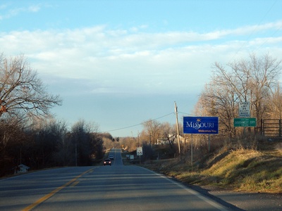
The Missouri–Oklahoma border cuts through a patchwork of farmland, rivers and small communities where state lines affect school districts, postal routes and local services. Whether you’re planning a drive, researching family history or just curious about border geography, these towns show how communities sit right at the meeting point of two states.
There are 9 Missouri – Oklahoma Bordering Towns, ranging from Hocker to Wyandotte. For each town, you’ll find below the data organized as: Country,State (county),Distance to MO-OK border (km) — presented so you can compare locations and distances at a glance; you’ll find below.
How were the towns chosen for this border list?
Towns were selected based on their municipal limits or recognized settlements lying on or immediately adjacent to the Missouri–Oklahoma state line, verified with maps and public geographic data; if a place straddles the line or sits within a few kilometers of it, it was included to reflect the local border community network.
Are the listed distances precise enough for travel planning?
Distances are measured to the nearest practical border point and given in kilometers as a helpful guide; they’re suitable for general planning, but use a navigation app or local signage for turn-by-turn directions and exact mileage when timing a trip.
Missouri – Oklahoma Bordering Towns
| Town | Country | State (county) | Distance to MO-OK border (km) |
|---|---|---|---|
| Quapaw | USA | OK (Ottawa) | 8 |
| Hornet | USA | MO (Newton) | 2 |
| Seneca | USA | MO (Newton) | 0 |
| Narcissa | USA | OK (Ottawa) | 5 |
| Wyandotte | USA | OK (Ottawa) | 9 |
| Tiff City | USA | MO (McDonald) | 0 |
| Noel | USA | MO (McDonald) | 6 |
| Hocker | USA | OK (Delaware) | 0 |
| Southwest City | USA | MO (McDonald) | 0 |
Images and Descriptions
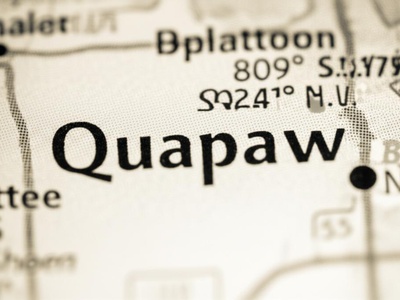
Quapaw
Population 809 (2020), at 36.95° N, 94.78° W. This small city is the headquarters of the federally recognized Quapaw Nation and is located near both the Kansas and Missouri borders in the far northeast corner of Oklahoma.

Hornet
Population ~50 (est.), at 36.93° N, 94.61° W. This unincorporated community is famous for the mysterious “Hornet Spook Light” or “Ozark Spook Light,” an unexplained ghostly light that has been appearing on a local road for over a century.
Seneca
Population 2,249 (2020), at 36.84° N, 94.61° W. Seneca’s western city limit is the state line itself, with one of its main thoroughfares aptly named State Line Road. It is located just across the border from a large territory of the Seneca-Cayuga Nation.
Narcissa
Population ~100 (est.), at 36.85° N, 94.67° W. A small, unincorporated agricultural community located west of the state line. It was named for Narcissa Chisholm Owen, a prominent member of the Cherokee Nation and a painter, musician, and writer.
Wyandotte
Population 488 (2020), at 36.79° N, 94.72° W. This town is home to the Wyandotte Nation of Oklahoma. It is situated near the confluence of the Neosho and Spring rivers, a historically significant area for numerous Native American tribes.
Tiff City
Population ~25 (est.), at 36.63° N, 94.61° W. A tiny unincorporated hamlet situated directly on the Missouri-Oklahoma state line along the scenic Elk River. It was once a mining community for “tiff,” a local name for the mineral barite.
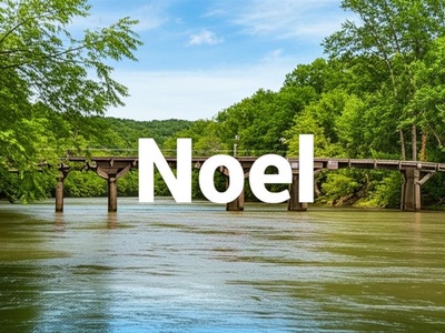
Noel
Population 2,124 (2020), at 36.54° N, 94.48° W. Nestled in the Ozark hills along the Elk River, Noel is known as the “Canoe Capital of the Ozarks.” It is a popular destination for floating, camping, and outdoor recreation.
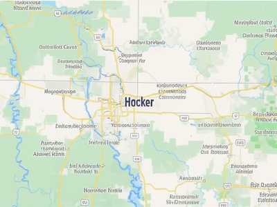
Hocker
Population ~10 (est.), at 36.52° N, 94.62° W. A tiny, unincorporated crossroads community located in Oklahoma’s northeast corner. It sits directly across the state line from the much larger town of Southwest City, Missouri, sharing a distinct border culture.
Southwest City
Population 921 (2020), at 36.52° N, 94.61° W. Uniquely located, the town’s southern and western limits touch the Arkansas and Oklahoma state lines, respectively. It is situated at one of the few points where three states meet.