North Dakota has more ghost towns than it has towns with a stoplight. The state once stitched itself together with railroad spurs, and when a spur got rerouted or pulled up, the town it fed usually died within a decade. Add the Depression, the slow drain of farm kids to the cities, and the rising waters of Lake Sakakawea in the 1950s, and you get a prairie dotted with grain elevators standing over nothing.
Most lists of these places give you a name, a sentence, and a single photo. That’s fine if you just want to scroll. But a lot of people searching for these towns want to actually drive out and stand in one — and that’s where the existing guides go quiet. No coordinates, no road conditions, no word on whose land you’re about to walk onto.
This is the visit-ready version. Fifteen towns, organized by region so you can string a few together in a day, each with its history, its condition right now, and the directions to find it. There’s a section at the end on visiting without making enemies of the locals, because almost every one of these sits on or next to private land.
Table of Contents
- Why North Dakota Emptied Out
- Central North Dakota (Near Minot & Bismarck)
- Western North Dakota (Badlands Country)
- Eastern & Southern North Dakota
- How to Visit a Ghost Town Without Getting Yelled At
- Best Season to Go
Why North Dakota Emptied Out
The short version: the railroad giveth, and the railroad taketh away.
When the Great Northern and Northern Pacific lines pushed across the territory in the 1880s, towns sprouted at roughly seven-to-ten-mile intervals — the distance a farmer could haul a wagon of grain to an elevator and get home the same day. Speculators platted hundreds of these townsites, each betting it would become the next Fargo. Most never cleared a few hundred people.
Then the math changed. Trucks and better roads meant grain didn’t need an elevator every ten miles. The railroads consolidated and abandoned branch lines through the 1920s and ’30s, and a town cut off from the rails had no reason to exist. The Dust Bowl and Great Depression gutted the farm economy on top of it. Families that left in the 1930s never came back.
The last big eraser was water. When the Garrison Dam was completed in 1953, the reservoir behind it — Lake Sakakawea — drowned entire communities and most of the Fort Berthold Reservation’s best bottomland, displacing the Mandan, Hidatsa, and Arikara. Whole towns were relocated or simply submerged.
What’s left is a state where the population peaked around 1930 and didn’t return to that number for seventy years. The ghost towns are the receipts.
Central North Dakota (Near Minot & Bismarck)
This is the densest cluster for day-trippers, and the easiest to reach if you’re flying into Minot or Bismarck. You can hit three or four of these in an afternoon loop.
1. Sims
Sims is the oldest German settlement in the state, founded in 1883 around a clay deposit that fed a short-lived brick and pottery works. The brick plant failed, the railroad bypassed the boom, and the people left — but the 1884 Sims Scandinavian Lutheran Church is still standing and still holds occasional services, which makes it one of the more dignified ruins in the state.
The parsonage next door is famously said to be haunted by “the lady in white,” and locals will tell you the story if you ask. Condition: church well-maintained, most townsite gone. Location: about 35 miles west of Bismarck, off I-94 near Almont (roughly 46.7167° N, 101.6° W).
2. Arena
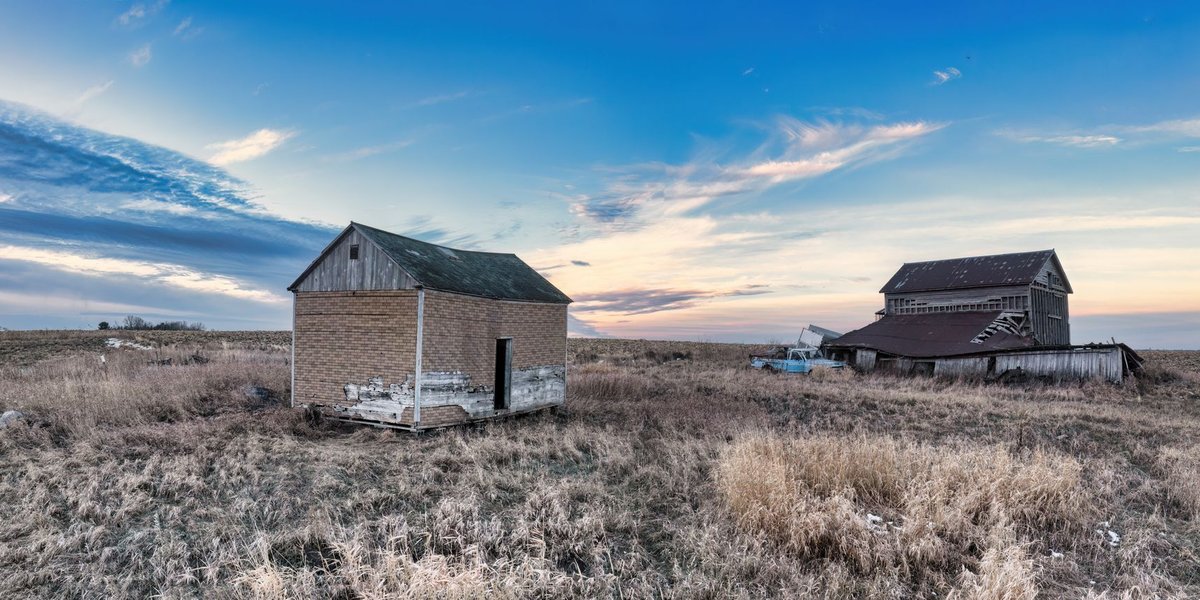
Arena had a bank, a school, a couple of churches, and a few hundred people in its prime. Today the most photographed structure is the abandoned schoolhouse and a leaning church, both visible from the gravel road. It’s one of the better-preserved “looks like everyone left yesterday” sites.
Condition: several intact buildings, deteriorating. Location: Burleigh County, roughly 40 miles northeast of Bismarck near Wing (47.05° N, 100.07° W). Roads are gravel and turn to gumbo when wet — don’t attempt after rain.
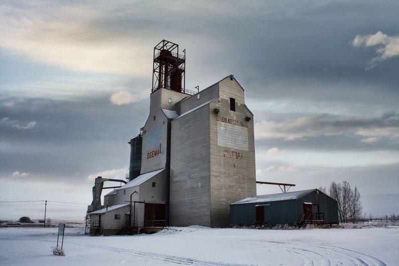
3. Balfour
Balfour isn’t fully dead — a handful of residents remain — but the downtown is a row of empty storefronts and a grand old brick bank building that looks transplanted from a bigger city. It’s a favorite of photographers for exactly that contrast: small-town scale, big-city ambition, all of it stalled.
Condition: partially occupied, commercial core abandoned. Location: McHenry County, on US-52 between Minot and Velva (47.95° N, 100.53° W). Easy paved access, which is rare.
4. Balta
Balta is a slow fade rather than a clean death — a near-empty town with a striking, oversized Catholic church (St. Peter and Paul) that towers over the surrounding fields. The church is the draw. The town around it is mostly memory.
Condition: a few residents, dominant church intact. Location: Pierce County, about 25 miles south of Rugby (48.17° N, 100.03° W).
5. Coleharbor area / Old Sanger
Sanger sat on the Missouri River and was a steamboat-era town that the highway and the river both passed by. Little remains above ground, but the old Sanger cemetery and a few foundations mark the spot, and the river setting makes it worth the short detour if you’re already near Lake Sakakawea.
Condition: mostly site-only, cemetery intact. Location: Oliver County, on the west bank of the Missouri near Hensler (47.27° N, 101.25° W).
Western North Dakota (Badlands Country)
Out here the ghost towns come with scenery — the broken buttes of the Badlands and the Little Missouri country. Pair these with a stop at Theodore Roosevelt National Park.
6. Tagus

Tagus is the postcard ghost town of North Dakota, the one that shows up on every list — and for once the hype is earned. The standout is a sturdy concrete bank vault and bank building standing alone in the grass, plus a few wood-frame structures slowly collapsing around it. Founded as a Great Northern stop, it peaked early and emptied by mid-century.
Condition: several photogenic standing structures. Location: Mountrail County, about 30 miles west of Minot off US-2 (48.32° N, 101.93° W).
7. Temple
Just down the line from Tagus, Temple offers a near-identical setup with fewer visitors: a stout bank building, an old store, and a scatter of houses. If Tagus has a tour bus, Temple won’t. The two make a natural pair on the same drive.
Condition: a handful of standing buildings. Location: Williams County, west of Tagus along the old Great Northern route near Wildrose (48.4° N, 102.2° W).
8. Epping
Epping is technically still alive — small population, but home to the Buffalo Trails Museum, which occupies several original early-1900s buildings and is one of the best places in the state to understand what these towns actually looked like when they were full. Treat it as the “living history” stop on a ghost-town circuit.
Condition: occupied with preserved historic core. Location: Williams County, off US-2 northeast of Williston (48.29° N, 103.36° W).
9. Charbonneau
Named for Toussaint Charbonneau, the interpreter on the Lewis and Clark expedition, this McKenzie County town faded with its railroad spur. A few buildings and the surrounding badlands terrain make it a quiet, scenic stop for those willing to drive gravel.
Condition: minimal structures, scenic site. Location: McKenzie County, north of Watford City (47.95° N, 103.5° W). This is oil country now, so expect truck traffic on the section roads.
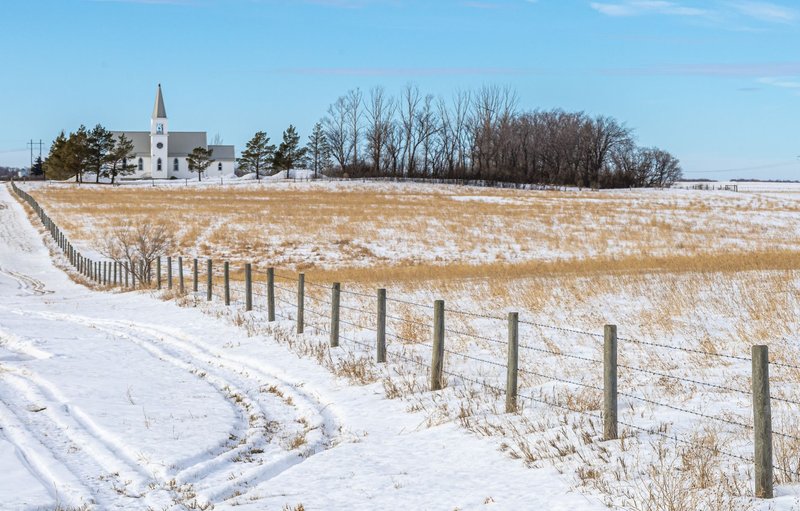
10. Lefor
Lefor’s signature is its hilltop Catholic church, St. Elizabeth, visible for miles across the rolling country southwest of Dickinson. The town below it has dwindled to almost nothing, but the church and its setting are genuinely worth the drive.
Condition: church intact, town nearly gone. Location: Stark County, about 15 miles southwest of Dickinson (46.68° N, 102.85° W).
Eastern & Southern North Dakota
The eastern half of the state is flatter and more farmed, so the ghost towns hide better. These reward people who like the hunt.
11. Bluegrass
Bluegrass is a Kidder County favorite — a small cluster of weathered buildings including an old store and elevator standing in classic prairie isolation. It photographs beautifully in low light, which is why it shows up in so many North Dakota galleries.
Condition: several standing structures. Location: Kidder County, north-central ND near Tappen (47.05° N, 99.6° W). Gravel access.
12. Griffin
Griffin sits in Sargent County in the southeast and is one of those towns that left behind a surprisingly complete-looking main street fragment — enough that you can read the shape of the old commercial block. It’s a longer drive from anywhere, which keeps it empty. If you’re already this close to the line, it’s an easy excuse to keep going south into the neighboring state’s ghost towns in South Dakota, which carry the same railroad-and-Depression story across the border.
Condition: partial main street standing. Location: Sargent County, southeastern ND near Forman (46.1° N, 97.6° W).
13. Omemee
Omemee, in Bottineau County near the Canadian border, is best known for its school ruins and the eerie completeness of its street grid with almost nothing left on it. It was once a substantial town with multiple churches and a busy depot.
Condition: site and scattered ruins. Location: Bottineau County, north-central ND (48.85° N, 100.7° W).
14. Wheelock
Wheelock predates its county seat and once expected to be the regional power before the railroad chose elsewhere. A few sturdy buildings, including an old church, remain. It’s an easy add-on if you’re already running the Tagus–Temple western loop.
Condition: a few intact buildings. Location: Williams County, off US-2 east of Williston (48.4° N, 103.0° W).
15. Manning
Manning is the ghost town that’s still the county seat — Dunn County’s courthouse sits in a town of barely a dozen people, which gives it a uniquely surreal feel. There’s a small museum and the courthouse, and not much else, in a town that legally still runs a county.
Condition: tiny population, courthouse and museum active. Location: Dunn County, north-central west ND near Killdeer (47.23° N, 102.77° W).
How to Visit a Ghost Town Without Getting Yelled At
Here’s the part the photo listicles skip. Almost none of these towns are public parks. The land is owned — usually by a rancher or farmer whose family has been there for generations — and the buildings, however abandoned they look, belong to someone.
A few ground rules that keep this hobby alive:
- Assume it’s private property. If there’s a fence, a gate, or a “No Trespassing” sign, that’s the answer. Many great shots are gettable from the public road or road right-of-way without setting foot on private land.
- Ask when you can. If you see a farmhouse nearby, knock. North Dakotans are, as a rule, friendly to a polite stranger who asks first. A yes turns a sketchy trespass into a welcome.
- Don’t go inside collapsing buildings. These structures are a century old with rotted floors and hidden wells. People have been hurt and worse. Photograph the exterior.
- Take nothing. No bricks, no bottles, no door hinges. Removing artifacts is both illegal in many cases and the fastest way to get a site posted and gated.
- Watch the roads. Most of these sit at the end of gravel or “minimum maintenance” roads. North Dakota gumbo turns to greased clay when wet — a dry road can become impassable in twenty minutes of rain. Carry water, a full tank, and a paper map, because cell coverage drops out fast. The state’s official road conditions map is worth checking before you head out.
Respect the place and it stays open to the next person. The reason a lot of these towns are now gated is the carload that came before you.
Best Season to Go
Late spring through early fall — roughly May to September — is the practical window. The roads are dry, the light is long, and you won’t get caught in a blizzard on a section road thirty miles from pavement.
September and early October are the sweet spot: harvest is finishing, the prairie goes gold, the air is clear, and the low-angle light makes a leaning grain elevator look like a cathedral. Winter is brutal and the back roads are often unplowed. Summer works but afternoon thunderstorms can strand you on gumbo, so go in the morning and watch the sky.
Bring more water than you think you need, gas up before you leave the last real town, and tell someone where you’re headed. These places have been waiting a hundred years. They’ll keep until the road dries out.