Ask the internet which bays Senegal has, and you get a mess. A Wikipedia category page lists two. A pollution report covers one. A travel guide raves about the Sine-Saloum without ever calling its inlets “bays.” Nobody puts the whole picture in one place.
So here it is. Senegal’s Atlantic coastline runs roughly 530 kilometers, from the Mauritanian border down to Guinea-Bissau, and it bends into a handful of named bays plus the maze of tidal inlets in the Saloum Delta. Some are working fishing harbors. One is the most infamous polluted bay in West Africa. A couple are quietly the reason eco-tourists fly to Dakar in the first place.
This is the list — what each bay is, where it sits, and whether it’s worth your time.
Table of Contents
- Senegal’s coastline in brief
- Yof Bay, Dakar
- Hann Bay, Dakar
- The Sine-Saloum Delta inlets
- Soumbédioune and the Cap-Vert coves
- How to visit
Senegal’s coastline in brief
Senegal sits at the westernmost point of mainland Africa. The Cap-Vert peninsula — the bulb of land Dakar is built on — juts into the Atlantic and creates the country’s only real dramatic coastal geography. Almonst everything north of Dakar is straight, open beach pounded by surf. Everything south, past the Petite Côte, dissolves into the mangrove channels of the Saloum Delta.
That shape matters for one reason: a true sheltered bay needs a headland or a river mouth to form. Senegal has both, but only in specific places. The Cap-Vert peninsula gives you Yof and Hann. The Saloum and Sine rivers, emptying into the Atlantic through a UNESCO-listed delta, give you dozens of branching inlets that function as bays even if no map labels them that way.
The Lebou people — the fishing community indigenous to the peninsula — settled these protected waters centuries before Dakar existed as a city. Most of the bay-side villages you’ll see today trace back to them, and the pirogues (the long painted wooden canoes) launching off the sand are doing the same job they’ve done for generations. Senegal’s inlets are also a small slice of a much bigger map — they sit alongside the wider catalog of bays across the African continent, from the Cape coves of South Africa to the harbors of the Mediterranean north.
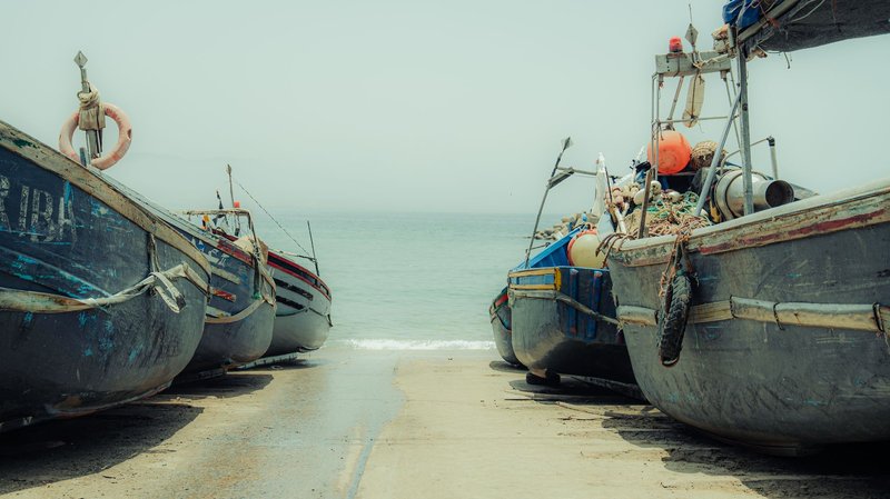
Yof Bay, Dakar
Yof Bay sits on the northern edge of the Cap-Vert peninsula, just south of Dakar’s airport. It’s named for Yoff, the large Lebou fishing village that lines it — one of the oldest continuously inhabited settlements in the Dakar area and still governed in part by traditional Lebou structures rather than purely municipal ones.
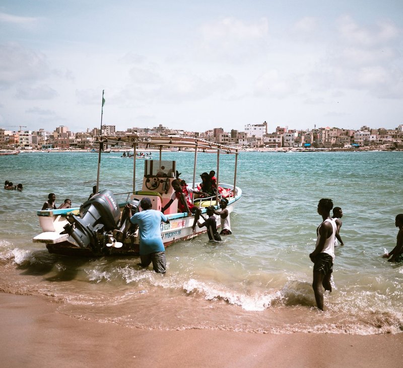
The bay is a working harbor first and a beach second. Mornings, the sand fills with pirogues coming in heavy with thiof, sardinella, and whatever else the night’s nets caught. The fish market that follows is loud, fast, and not built for tourists, which is exactly why it’s worth seeing. This is where a real share of Dakar’s seafood actually changes hands.
Yoff is also the spiritual home of the Layene Brotherhood, a Sufi order founded here in the late 19th century. Their mosque sits near the water, and during the annual Layene pilgrimage the bay’s shoreline fills with white-robed worshippers. If you want the cultural texture the guidebooks skip, this is it: a bay that’s simultaneously a fish depot and a holy site.
Swimming here is decent on calm days, though the water quality swings with the fishing activity. Go for the village and the morning catch, not for a beach day.
Hann Bay, Dakar
Hann Bay is the one you’ve probably read about, and not for good reasons. Geographically, it’s a gift — a wide, naturally sheltered crescent on the eastern side of the Cap-Vert peninsula, the kind of calm, protected water that should be Dakar’s prime beach. Specialists have called it one of the most beautiful bays in the world by raw shape.
Then industry arrived. From the mid-20th century, factories, the port, and unmanaged sewage from a growing city all drained into Hann. The result was a bay so fouled with waste that locals nicknamed it “Trash Bay.” Raw sewage, industrial effluent, and solid garbage turned a swimming beach into a public-health problem, and the fishing community that depended on it watched the catch collapse.
The cleanup is real and ongoing. A long-planned sanitation program — backed by international development financing — is building wastewater treatment and intercepting the sewage lines that empty into the bay. The African Development Bank has been among the institutions financing the Hann Bay depollution effort, which targets the treatment of wastewater from the surrounding industrial and residential zones before it reaches the water.
Progress is slow and the bay is not yet a place you’d swim. But Hann matters to this list precisely because it’s the cautionary tale: the best-shaped bay in Senegal, nearly destroyed, now the subject of one of West Africa’s biggest coastal rehabilitation projects. Worth understanding before you judge it by old photos.
The Sine-Saloum Delta inlets
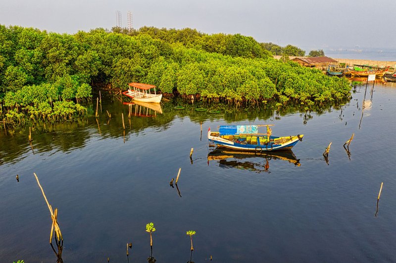
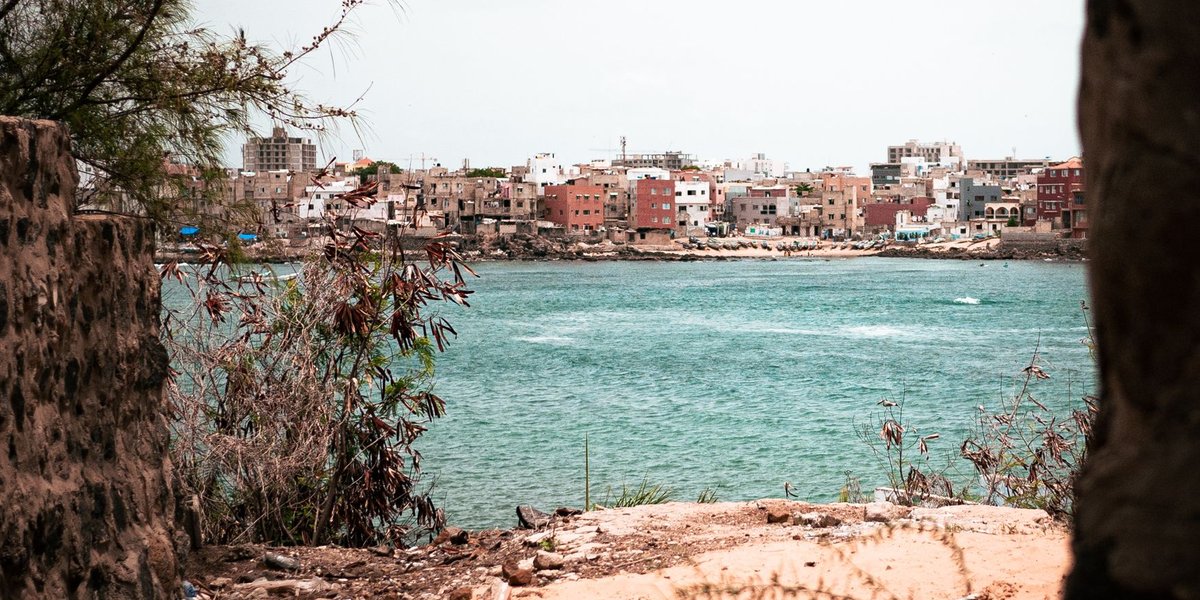
Drive about three hours south of Dakar and the coastline stops being a line and becomes a puzzle. The Sine-Saloum Delta is where the Saloum and Sine rivers meet the Atlantic, spreading into roughly 180,000 hectares of mangrove channels, tidal flats, islands, and brackish inlets. UNESCO inscribed it as a World Heritage Site in 2011, citing both its biodiversity and the hundreds of shell mounds — some over 2,000 years old — left by the people who’ve fished these waters since antiquity.
The delta doesn’t have “bays” in the postcard sense. What it has are bolongs — the local term for the tidal channels that branch and rejoin between the mangroves. Functionally they’re sheltered inlets, and they’re the real draw of Senegal’s coast for anyone who cares about wildlife.
This is birding country. The delta hosts pelicans, flamingos, royal terns, and herons in serious numbers, and the Parc National du Delta du Saloum protects the densest stretches. Pink flamingos wade the shallows; ospreys hunt the channels. Take a pirogue out at dawn and you’ll pass oyster beds clinging to mangrove roots, harvested by women from the surrounding villages.
Bases for exploring are villages like Toubacouta, Ndangane, and the island of Mar Lodj. From any of them you can hire a boat to thread the bolongs, visit a shell-mound island, or reach the sandbar beaches where the delta finally meets open ocean. If you came to Senegal for one piece of coast, the Saloum inlets are the answer.
Soumbédioune and the Cap-Vert coves
Back in Dakar proper, the western edge of the peninsula curls into a series of small coves rather than true bays — and the best known is Soumbédioune. It’s a tight horseshoe of sand on the Atlantic side of the city, famous for two things: its evening fish market and its craft village.
Each afternoon the pirogues land here, and the market that follows is more accessible than Yoff’s — closer to central Dakar, more used to visitors, and set against a sunset that hits the water dead-on. The adjacent artisan village sells the wood carvings, leather, and silver you’ll see hawked everywhere else in the city, minus a few layers of markup.
The water itself is exposed Atlantic — currents are strong and it’s not a swimming cove. Come for the catch landing and the sunset, the way locals do, and stay for grilled fish at one of the stalls.
These western coves, including the stretch below the Mamelles lighthouse and the larger Soumbédioune curve, are what give Dakar its sea-facing character. None are sheltered bays in the Hann or Yof sense, but they’re part of the same coastline story.
How to visit
A few practical notes if you’re building these into a Senegal trip:
- Yof and Hann are inside greater Dakar. Yof is a short ride from the city or the airport; go early for the fish market. Hann is east of downtown and currently more of a “see the cleanup, understand the history” stop than a beach day.
- Soumbédioune is central Dakar and easiest to fold into a city day. Aim for late afternoon to catch the boats and the sunset market together.
- The Sine-Saloum Delta is the overnight trip. Plan two to three days, base in Toubacouta or Ndangane, and book a pirogue tour through your lodge — the channels are confusing and a local boatman is non-negotiable. The dry season, roughly November to May, gives you the best birding and the calmest water.
Senegal’s bays don’t compete with the Mediterranean for turquoise-water glamour, and that’s not the point. They’re working coast — fishing harbors, sacred shorelines, a delta that’s half ecosystem and half archive. Yof for the catch, the Saloum for the wildlife, Hann as a lesson in what a coastline can lose and try to win back. That’s the real map of bays in Senegal, finally in one place.