Explore a definitive list of the 15 bays in Cape Cod, organized by town with precise coordinates (lat, lon) and area in km² to help boaters, beachgoers, and researchers locate and compare each bay. Use the map-ready data to plan coastal outings, discover harbors, and pick the best spots for swimming, fishing, or sightseeing along Cape Cod’s shore.
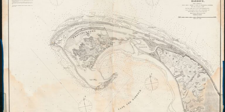
Ethnic Groups in North America: The Complete List
This comprehensive post lists 46 Ethnic Groups in North America, providing estimated populations, primary regions or countries, and main languages for each group. Whether you’re researching demographics, genealogy, or cultural diversity, this complete list offers clear, sourced data and quick-reference tables to explore North America’s multicultural makeup.
List of Indigenous Languages in Saint Lucia
Explore a concise list of Indigenous Languages in Saint Lucia, detailing three languages, their status, language families, and historical regions. This post provides historical context and current status to help readers understand the island’s linguistic heritage—learn more about these distinct languages and their cultural importance.
Bays in Martha’s Vineyard: The Complete List
This guide lists all five bays in Martha’s Vineyard with town names, precise coordinates, and practical access & activities information. Whether you’re planning to kayak, fish, swim, or chase sunsets, find maps, parking tips, and activity suggestions to help you make the most of each bay.
The Complete List of Panama Passport Visa-Free Countries
This post lists all 94 Panama Passport Visa-free Countries, showing visa type and allowed stay (days) for each destination. Use this up-to-date guide to plan visa-free travel, identify visa-on-arrival options, and compare allowed stays—perfect for Panamanian travelers, travel planners, and visa researchers. Click to explore the full list and practical tips.
List of Bays in Newfoundland
This comprehensive list catalogs 40 Bays in Newfoundland, providing coordinates, region designations, and nearby towns to help travelers, researchers, and locals explore the province’s coastal geography. Use the map-ready coordinates and regional grouping to plan visits, study marine habitats, or trace fishing and settlement patterns along Newfoundland’s rugged Atlantic shore.
Poorest Areas in Grenada: The Complete List
This post lists the 7 Poorest Cities in Grenada, providing poverty rates and median household income (XCD/year) for each area to give clear, comparable insight. Read concise profiles, hard data, and local context to understand where economic hardship is concentrated and what factors contribute — useful for researchers, NGOs, policymakers, and anyone interested in Grenada’s socioeconomic landscape.
The Complete List of Idaho – Utah Bordering Towns
This post provides a complete list of Idaho – Utah Bordering Towns, showing each town’s state, country, and distance to the border in kilometers. Ideal for travelers, researchers, and anyone checking proximity to the Idaho–Utah state line, this concise reference makes it easy to find nearby border communities at a glance.
List of Haiti Ethnic Groups
This post lists the 12 Haiti ethnic groups and provides quick facts for each: population share (%), primary region(s), and origin/ancestry. Explore concise profiles that illuminate Haiti’s demographic composition, historical roots, and cultural diversity with clear, sourced entries and regional context.
List of Airports In Grenada
This concise list covers all Airports in Grenada, providing IATA/ICAO codes, island and town locations with coordinates, main runway lengths, and practical notes for each facility. Ideal for travelers, pilots, and aviation enthusiasts planning flights to Grenada and Carriacou.
