The safest neighborhoods in Houston sit mostly on the edges of the city: Kingwood and Lake Houston in the far northeast, Clear Lake near NASA in the southeast and the Memorial and Spring Branch areas west of Loop 610. Inside the Loop, River Oaks and the Heights also make the list. Between June 2025 and May 2026, 10 of the 84 super neighborhoods with at least 3,000 residents recorded fewer than 4.4 violent crimes per 1,000 people, half the city rate of 8.9. Together they house 14% of Houstonians and account for 4.4% of the city’s violent crime.
Safest neighborhoods in Houston: Kingwood Area, Lake Houston and Hunterwood in the northeast. Westbranch and Spring Branch North in the northwest. Memorial on the west side. Afton Oaks / River Oaks and Greater Heights inside the Loop. Braeswood in the southwest. Clear Lake in the southeast.
By part of town, Southwest & West Houston has the lowest combined rate, 7.3 violent crimes per 1,000 residents. Citywide, violent crime dropped 19% from the previous 12 months. University Place, home to Rice University, is left out of the ranking: Rice’s own police department handles crime on campus, so its low count does not measure the neighborhood.
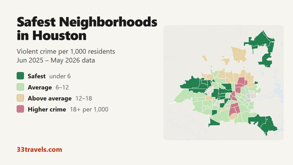
Map of the safest neighborhoods in Houston
Dark green marks super neighborhoods with fewer than 6 violent crimes per 1,000 residents, and pale green marks those from 6 to 12, around the city rate. The safest list in this article uses a stricter line, half the city rate. Tan and rose shapes have rates above 12. Grey shapes are super neighborhoods with fewer than 3,000 residents, along with Bellaire, West University Place and the Memorial Villages, which have their own police departments. The view buttons zoom to the Inner Loop, the north, the southwest and west or the east and southeast. Switch the layer to Theft & robbery to compare theft and robbery, and tap any shape to see its counts.
Violent crime per 1,000 residents
Thefts & robberies per area
Tap or hover a neighborhood to see its crime numbers.
Table of Contents
- Safest neighborhoods in Houston
- Best neighborhoods in Houston
- Safe areas in Houston for tourists
- Is Kingwood safe?
- Is Clear Lake safe?
- Low numbers that mislead
- Where crime is higher
- Safest suburbs of Houston
- Tips for choosing a neighborhood
- How this map was made
- FAQ
Safest neighborhoods in Houston
These are the 15 super neighborhoods of 3,000 or more residents with the lowest violent crime rates. In an area of 3,000 people a single crime adds about 0.3 to the rate, so read the top of the table as a group rather than a strict order. The ten rows above Fort Bend Houston are under the safe line of half the city rate. Hunterwood and Westbranch are the two smallest in the group and recorded 10 and 7 violent crimes.
| Neighborhood | Council district | Violent crimes per 1,000 | vs. city avg | Homicides | Aggravated assaults | Thefts + robberies |
|---|---|---|---|---|---|---|
| Lake HoustonDistrict E | District E | 1.0 | 0.1x | 0 | 23 | 85 |
| WestbranchDistrict A | District A | 1.6 | 0.2x | 0 | 6 | 60 |
| Kingwood AreaDistrict E | District E | 2.1 | 0.2x | 0 | 99 | 685 |
| Clear LakeDistrict E | District E | 2.2 | 0.3x | 1 | 103 | 862 |
| MemorialDistrict G | District G | 3.0 | 0.3x | 1 | 109 | 1,195 |
| HunterwoodDistrict I | District I | 3.2 | 0.4x | 0 | 5 | 27 |
| Afton Oaks / River Oaks AreaDistrict G | District G | 3.5 | 0.4x | 3 | 28 | 418 |
| BraeswoodDistrict C | District C | 3.8 | 0.4x | 0 | 63 | 567 |
| Greater HeightsDistrict C | District C | 3.9 | 0.4x | 1 | 123 | 1,664 |
| Spring Branch NorthDistrict A | District A | 4.2 | 0.5x | 0 | 66 | 222 |
| Fort Bend HoustonDistrict K | District K | 4.4 | 0.5x | 2 | 117 | 421 |
| South Belt / EllingtonDistrict E | District E | 4.7 | 0.5x | 3 | 221 | 885 |
| Greater UptownDistrict G | District G | 4.7 | 0.5x | 1 | 179 | 2,762 |
| LangwoodDistrict A | District A | 4.7 | 0.5x | 1 | 26 | 141 |
| Greenway / Upper Kirby AreaDistrict C | District C | 5.0 | 0.6x | 1 | 77 | 1,652 |
Kingwood, Lake Houston and the northeast
Lake Houston has the lowest rate in the city at 1.0. The super neighborhood lies along the east shore of the reservoir it is named for and takes in the Lakewood Heights subdivision. Kingwood Area, on the other side of the lake, is the largest neighborhood in the top 15 with 65,014 residents and a rate of 2.1. The lake bounds it on the east and south, Sorters Road on the west and the Harris County line on the north. Hunterwood, a subdivision east of Greens Bayou, rates 3.2.
Memorial and Spring Branch
Memorial runs from Interstate 10 south to Buffalo Bayou, between the Memorial Villages and roughly State Highway 6, with Memorial Drive as its main road. Its 53,459 residents recorded a rate of 3.0. The Energy Corridor, City Center and Memorial City sit along its I-10 edge. North of the freeway, Spring Branch North lies between Clay Road, Campbell Road and the Sam Houston Parkway and rates 4.2. Westbranch, north of Clay Road at the Beltway, rates 1.6, and Langwood, east of Spring Branch North around Langwood Park, rates 4.7.
River Oaks, the Heights and the Inner Loop
Afton Oaks / River Oaks has the lowest rate of the ranked Inner Loop neighborhoods, 3.5. The city calls River Oaks Houston’s first master-planned community, and the area holds the River Oaks Shopping Center, Highland Village and the Hogg Bird Sanctuary. Greater Heights, north of I-10 between I-45 and White Oak Bayou, rates 3.9 with 47,659 residents. Greenway / Upper Kirby, between Westheimer Road, Kirby Drive and Bissonnet Street, rates 5.0 and holds the Greenway Plaza office towers.
Braeswood and Fort Bend Houston
Braeswood is a cluster of subdivisions built after World War II along Brays Bayou, with Linkwood, Bonham and Karl Young parks and a community center on Stella Link Road. It rates 3.8. Farther out, Fort Bend Houston lies between Beltway 8 and McHard Road in the part of the city that crosses into Fort Bend County. Its rate of 4.4 sits right at half the city rate, the cutoff for the safest list.
Clear Lake and the southeast
Clear Lake rates 2.2, the lowest in East & Southeast Houston, with 60,756 residents. It borders NASA’s Johnson Space Center and holds Space Center Houston and the University of Houston-Clear Lake. South Belt / Ellington, at the crossing of Beltway 8 and the Gulf Freeway around Ellington Field and Almeda Mall, rates 4.7.
Best neighborhoods in Houston
Low crime is only one test. The best neighborhoods in Houston for a short visit, a family or a first apartment also depend on distance to work and sights, parks and price. The four groups below use the same crime data.
Best neighborhoods for visitors
Visitors who drive can base in Greater Uptown, around the Galleria. It rates 4.7, about half the city rate, but recorded the most thefts of any Houston neighborhood, so park in a staffed garage. The Westin Galleria and The Westin Oaks are inside the mall, and the JW Marriott is across the street. The mall staffs close to 40 officers at peak times and has two police substations, according to KPRC in July 2025. The METRORail Red Line links Downtown, the Museum District and the Texas Medical Center for $1.25 a ride or $3 for a day pass.
Best neighborhoods for families
Kingwood, Clear Lake and Memorial combine low crime with parks and libraries. Kingwood borders the 5,000-acre Lake Houston Park for 2.5 miles on its northeast side and has Kingwood Park on Bens Branch. Clear Lake has Rodriguez and Williams parks. Memorial is served by the Kendall Neighborhood Library on North Eldridge Parkway. Closer in, Braeswood has the McGovern-Stella Link Regional Library, and Greater Heights has Stude Park, Milroy Park and the Heights Neighborhood Library on Heights Boulevard.
Best neighborhoods for young professionals
Greater Heights pairs a low violent crime rate with a historic center on Heights Boulevard, but it also has the most stolen vehicles in Houston. Heights Boulevard was laid out in 1892 with a wide esplanade and Victorian houses, and the historic district joined the National Register in 1983. Washington Avenue Coalition / Memorial Park, between the Heights and Buffalo Bayou, rates 5.5 and has the Washington Avenue bars and the 1,500-acre Memorial Park with its 3-mile running loop, with more than one and a half times the city’s thefts per resident. Montrose has more nightlife and six city historic districts but rates 7.6, close to the city average.
Best affordable safe neighborhoods
Among areas rated well below the city rate, Westbury and Spring Branch Central have the lowest housing costs. They rate 5.1 and 5.8. Census Bureau estimates for 2020 to 2024 put median home values there near $262,000 and $334,000, and median rent near $1,660 and $1,370 a month. Clear Lake and Lake Houston, two of the lowest-crime areas, have home values near $305,000. Greater Heights and Memorial run $590,000 to $650,000, and much of River Oaks is at $2 million or more. All values are tract-based estimates.
Safe areas in Houston for tourists
The safe areas in Houston for tourists, measured by violent crime among residents, are around the Galleria, in Museum Park and at Space Center Houston in Clear Lake. Theft runs high in the first two. Hermann Park, the Houston Zoo and the Museum of Natural Science sit in the Medical Center Area, which has too few residents for a rating. Museum Park, the neighborhood north of Hermann Park with the Children’s Museum, rates 5.1 but recorded 398 thefts for 6,514 residents, more than twice the city’s theft rate per resident. Greater Uptown recorded 2,703 thefts, the most of any Houston neighborhood. Both counts reflect crowds of shoppers and museum visitors measured against residents only. Downtown and Midtown, with the convention center, the stadiums and the bars, rate 19.2 and 21.9, more than twice the city rate.
Is Kingwood safe?
Yes. Kingwood Area recorded 135 violent crimes in 12 months among 65,014 residents, a rate of 2.1, under a quarter of the city’s. It also recorded 670 thefts, well under the city rate per resident. HPD runs a 24-hour station on Rustic Woods Drive. Harris County Constable Precinct 4 also patrols parts of Kingwood, and the reports its deputies take do not appear in HPD’s file. Lone Star College Kingwood, with about 7,000 students, has its own police as well.
Is Clear Lake safe?
Yes. Clear Lake recorded 131 violent crimes for a rate of 2.2, the fourth lowest in the ranking. Theft is also low: 847 thefts, about half the city rate per resident. HPD has a 24-hour station on Bay Area Boulevard, and UH-Clear Lake has its own police force. Webster, a separate city next to Clear Lake, reported 61 violent crimes in 2025 for 12,574 residents in FBI data, a higher rate than Clear Lake.
Low numbers that mislead
University Place rates 1.9, third lowest in the city, but the Rice University campus tract holds about 2,900 of its residents while Rice University Police handle crime on campus. That gap pulls its rate down, so it is not in the ranking. The Medical Center Area, with the Texas Medical Center, Hermann Park and the zoo, has 2,615 residents and no rating. Texas Medical Center Police patrol it.
Bush Intercontinental is different: the IAH / Airport Area has 11,629 residents and rates 14.1, above the city average, because its count includes the terminals, hotels and parking lots. Greenway / Upper Kirby and Washington Avenue / Memorial Park are both in the lower-rate group but record more than one and a half times the city’s thefts per resident. Both draw office, bar and park crowds that the resident count leaves out.
Where crime is higher
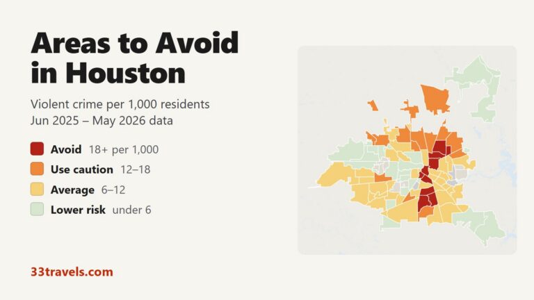
North Houston and East & Southeast Houston have the highest combined rates, 10.3 and 10.2 per 1,000. The highest-rate neighborhoods are in the northeast, around Kashmere Gardens and Fifth Ward, and south of Downtown, in Third Ward, OST / South Union and Sunnyside. Our areas to avoid in Houston guide covers those 10 neighborhoods.
Safest suburbs of Houston
The suburban departments in the table together reported 2.15 violent crimes per 1,000 residents in 2025, against 8.88 for Houston in the same FBI data. League City and Sugar Land report the lowest rates of the larger suburbs. Three smaller cities are not in the table: West University Place reported 5 violent crimes in 2025, Bellaire 24 and Katy 36. West University Place and Bellaire are enclaves surrounded by Houston, and West University Place borders University Place.
| City | Population | Violent crimes | Per 1,000 | Year |
|---|---|---|---|---|
| Houston | 2,413,559 | 21,423 | 8.9 | 2025 |
| Galveston | 53,510 | 271 | 5.1 | 2025 |
| Pasadena | 149,168 | 652 | 4.4 | 2025 |
| Baytown | 86,149 | 344 | 4.0 | 2025 |
| Conroe | 121,302 | 319 | 2.6 | 2025 |
| Rosenberg | 43,657 | 86 | 2.0 | 2025 |
| Missouri City | 79,654 | 120 | 1.5 | 2025 |
| La Porte | 38,764 | 52 | 1.3 | 2025 |
| Deer Park | 34,532 | 34 | 1.0 | 2025 |
| Friendswood | 41,358 | 34 | 0.8 | 2025 |
| Pearland | 130,539 | 107 | 0.8 | 2025 |
| Sugar Land | 109,606 | 80 | 0.7 | 2025 |
| League City | 119,427 | 72 | 0.6 | 2025 |
Murder, rape, robbery and aggravated assault reported to the FBI by each agency, per 1,000 residents of the population the agency reports. Source: FBI Crime Data Explorer. Agencies that report no complete year are left out.
Tips for choosing a neighborhood
- Look at the block as well as the super neighborhood. Areas such as Memorial and Kingwood cover dozens of subdivisions each.
- Check the Theft & robbery layer before choosing a hotel you will drive to. Car break-ins follow parking, not violent crime.
- Count the commute. Kingwood and Clear Lake sit at the city’s far edges, and the safest Inner Loop areas cost the most.
- For a visit without a car, stay near a Red Line station so Downtown, the museums and the Medical Center are a train ride away.
- Call 9-1-1 for emergencies and (713) 884-3131 for non-emergency police service within the city limits.
How this map was made
The ranking uses the Houston Police Department’s public NIBRS offense files for June 2025 through May 2026 and the city’s 88 super neighborhoods. Violent crime counts murder, rape and other forcible sex offenses, robbery and aggravated assault, summed by victim. Each rate divides that count by the 2020 Census population. Only super neighborhoods with 3,000 or more residents are ranked, and University Place is left out for the campus reason above. Crimes handled by campus police, METRO Police, constables and the Harris County Sheriff are not in HPD’s file. The suburban figures come from the FBI’s Crime Data Explorer and the housing costs from the Census Bureau’s 2020-2024 American Community Survey.
We ranked the safest neighborhoods in Milwaukee.
FAQ
What is the safest neighborhood in Houston?
Lake Houston, on the east shore of the reservoir in far northeast Houston, has the lowest violent crime rate at 1.0 per 1,000 residents. Westbranch (1.6) and Kingwood Area (2.1) follow. Westbranch is small enough that a few crimes change its place, while Kingwood, with 65,014 residents, is the largest of the three.
What part of Houston is the safest?
Southwest & West Houston has the lowest combined rate of the four parts of town, 7.3 violent crimes per 1,000 residents against 8.9 citywide. The single safest neighborhoods are on the edges: Lake Houston and Kingwood in the northeast and Clear Lake in the southeast.
What are the best neighborhoods to live in Houston?
For low crime and space, Kingwood, Clear Lake and Memorial. For the lowest Inner Loop rates, River Oaks and Greater Heights, at a higher price. For lower housing costs with crime rates well below the city rate, Westbury and Spring Branch Central.
Where is the safest place to stay in Houston as a tourist?
Visitors who drive can stay in the Galleria area, which rates 4.7 per 1,000 residents and has hotels inside and beside the mall. Visitors without a car can stay near a METRORail Red Line stop. Greater Uptown recorded the most thefts of any Houston neighborhood, so park in a staffed garage.
Is the Museum District in Houston safe?
Museum Park rates 5.1 per 1,000 residents, below the city rate but above the safe line, and its visitors are not counted. Hermann Park, the zoo and the Museum of Natural Science lie in an area too small to rate. Theft is the main risk: Museum Park recorded 398 thefts in 12 months.
Is Sugar Land safer than Houston?
Yes. In 2025 FBI data Sugar Land reported 0.73 violent crimes per 1,000 residents, against 8.88 for Houston. League City, Friendswood and Pearland report similar low rates.
Why do some Houston neighborhoods show little or no crime?
Three reasons. Bellaire, West University Place and the Memorial Villages have their own police departments, so they show grey on the map. Campus police at Rice, the University of Houston and the Texas Medical Center keep their own records, which pulls University Place's rate down. And the Medical Center Area has too few residents for a rate.