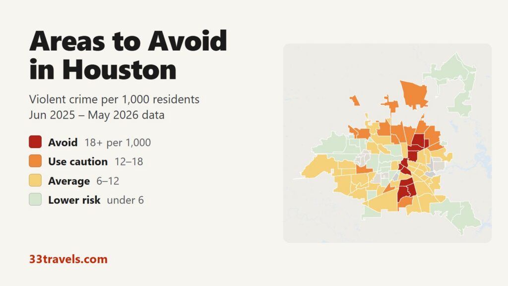
The areas to avoid in Houston sit in three groups: Fifth Ward and the neighborhoods north of it along Loop 610 on the northeast side, Downtown and Midtown, and the neighborhoods east of State Highway 288 from Third Ward south to Sunnyside and South Park. Between June 2025 and May 2026, 10 of Houston’s 88 super neighborhoods recorded 18 or more violent crimes per 1,000 residents, about twice the city rate of 8.9. They hold 7% of Houston’s residents and 19% of its violent crime, and 41 of its 223 homicides.
Neighborhoods to avoid in Houston: Downtown and Midtown in the center. Greater Fifth Ward, Kashmere Gardens, Trinity / Houston Gardens and Settegast on the northeast side. Greater Third Ward, Greater OST / South Union, Sunnyside and South Park south of Downtown, between State Highway 288 and Mykawa Road.
Houston’s violent crime rate is about twice Austin’s and sits between Philadelphia’s and St. Louis’s. The neighborhoods with the most violent crime are not on the avoid list: Alief and Sharpstown in southwest Houston recorded more violent crimes and more homicides than any avoid area, but they are home to 104,822 and 79,149 people, so their rates are below the city average. Downtown and Midtown rate high partly because their crime is divided among residents only, while many more people come there to work, watch games and go out. Citywide, violent crime fell 19% and homicides fell 32% compared with the 12 months before.
Houston safety map
Red areas are the places to avoid in Houston and orange areas call for caution. Grey shapes inside the city limit are separate cities with their own police, such as Bellaire, West University Place and the Memorial Villages. The three grey neighborhoods without a rating have fewer than 3,000 residents. Use the buttons to zoom to Downtown & Inner Loop, North, Southwest & West or East & Southeast, and switch to Theft & robbery to see where car break-ins and shoplifting happen. Tap or hover over a neighborhood for its numbers.
Violent crimes per 1,000 residents
Thefts & robberies per area
Tap or hover a neighborhood to see its numbers.
Table of Contents
- Areas to avoid in Houston
- Areas to be careful in
- Is downtown Houston safe?
- Is Midtown Houston safe at night?
- Is Montrose safe?
- Is the Galleria area safe?
- Is the Heights safe?
- Houston crime rate
- Car break-ins and car theft in Houston
- Safest neighborhoods to stay in Houston
- Pasadena, Sugar Land and the suburbs
- Houston safety tips for visitors
- How this map was made
- FAQ
Areas to avoid in Houston
These are the 10 super neighborhoods with 18 or more violent crimes per 1,000 residents. Nine of them are in City Council District B or District D, the two districts with the highest rates.
| Neighborhood | Council district | Violent crimes per 1,000 | vs. city avg | Homicides | Aggravated assaults | Thefts + robberies |
|---|---|---|---|---|---|---|
| Kashmere GardensDistrict B | District B | 29.6 | 3.3x | 3 | 231 | 292 |
| Greater OST / South UnionDistrict D | District D | 26.4 | 3.0x | 3 | 442 | 733 |
| Trinity / Houston GardensDistrict B | District B | 24.1 | 2.7x | 4 | 356 | 495 |
| SunnysideDistrict D | District D | 23.4 | 2.6x | 8 | 440 | 662 |
| Greater Fifth WardDistrict B | District B | 22.8 | 2.6x | 6 | 359 | 610 |
| MidtownDistrict D | District D | 21.9 | 2.5x | 3 | 150 | 1,822 |
| South ParkDistrict D | District D | 19.5 | 2.2x | 4 | 322 | 342 |
| DowntownDistrict I | District I | 19.2 | 2.2x | 5 | 256 | 1,850 |
| Greater Third WardDistrict D | District D | 18.8 | 2.1x | 4 | 231 | 743 |
| SettegastDistrict B | District B | 18.4 | 2.1x | 1 | 63 | 125 |
Fifth Ward, Kashmere Gardens, Trinity / Houston Gardens and Settegast
Kashmere Gardens has the highest rate in Houston, 29.6 violent crimes per 1,000 residents. It lies along Loop 610 on the northeast side, north of Fifth Ward, with small houses on large lots, a rail yard on its west side and warehouses on its east side. LBJ Hospital is on the Loop east of Lockwood Drive. With 9,668 residents it recorded 286 violent crimes, most of them aggravated assaults.
Greater Fifth Ward (22.8) is directly south, between Buffalo Bayou, Jensen Drive, Liberty Road and Lockwood Drive, and is the closest of the four to Downtown. Its main street is Lyons Avenue. Trinity / Houston Gardens (24.1) is north of Kashmere Gardens and has the highest rate in North Houston. Settegast (18.4) is the smallest avoid area, 4,195 residents east of a large rail switching yard, so a few crimes move its rate. Hotels and major attractions are not in these areas.
Downtown and Midtown
Downtown (19.2) is the area inside the freeway ring, including East Downtown (EaDo). It holds City Hall, the George R. Brown Convention Center, Discovery Green, Daikin Park and the Toyota Center. Only 20,562 people live there, against the office workers, fans and hotel guests who fill it by day. Theft is the most common crime: 1,750 thefts against 395 violent crimes.
Midtown (21.9) is the grid of apartments, bars and restaurants between Downtown and the Museum District, crossed by Main, Fannin, San Jacinto and Milam Streets. It has 12,623 residents and the most car break-ins of any Houston neighborhood. Its bar district has its own section.
Third Ward, OST / South Union, Sunnyside and South Park
Four avoid areas lie south of Downtown on the east side of State Highway 288. Greater Third Ward (18.8) runs from I-45 to SH 288 and holds Texas Southern University and Emancipation Park. Greater OST / South Union (26.4) is south of it, between Old Spanish Trail, SH 288, Loop 610 and Mykawa Road, around the former Palm Center mall.
South of Loop 610, Sunnyside (23.4) runs from SH 288 east toward Martin Luther King Boulevard, down to Sims Bayou. South Park (19.5) lies east of it, out to Mykawa Road. Sunnyside recorded 577 violent crimes and 8 homicides, the most of any avoid area, and Greater OST / South Union recorded 565. Hotels and major attractions are not in these four either.
Areas to be careful in
These 15 neighborhoods have 12 to 18 violent crimes per 1,000 residents. Together with the avoid areas they hold 22% of residents and 42% of violent crime. Eleven of the 15 are in North Houston, from Independence Heights and Acres Home out to Greater Greenspoint and the area around Bush Intercontinental Airport. Northside/Northline, the largest of them with 56,960 residents, recorded 546 aggravated assaults, the most in the city. South Main (17.7), on both sides of Loop 610 along South Main Street near the old Astroworld site, has the highest rate in southwest Houston.
| Neighborhood | Council district | Violent crimes per 1,000 | vs. city avg | Homicides | Aggravated assaults | Thefts + robberies |
|---|---|---|---|---|---|---|
| South MainDistrict K | District K | 17.7 | 2.0x | 1 | 143 | 576 |
| Eastex - Jensen AreaDistrict H | District H | 17.2 | 1.9x | 5 | 344 | 713 |
| El Dorado / Oates PrairieDistrict I | District I | 17.1 | 1.9x | 0 | 36 | 207 |
| Independence HeightsDistrict H | District H | 16.3 | 1.8x | 2 | 161 | 516 |
| Fairbanks / Northwest CrossingDistrict A | District A | 15.1 | 1.7x | 2 | 160 | 1,259 |
| East HoustonDistrict B | District B | 14.9 | 1.7x | 2 | 243 | 589 |
| South Acres / Crestmont ParkDistrict D | District D | 14.9 | 1.7x | 1 | 233 | 412 |
| Acres HomeDistrict B | District B | 14.2 | 1.6x | 3 | 308 | 604 |
| IAH / Airport AreaDistrict B | District B | 14.1 | 1.6x | 0 | 126 | 1,144 |
| East Little York / HomesteadDistrict B | District B | 13.7 | 1.6x | 3 | 229 | 434 |
| Greater GreenspointDistrict B | District B | 13.7 | 1.6x | 9 | 424 | 1,473 |
| Northside/NorthlineDistrict H | District H | 13.3 | 1.5x | 7 | 546 | 2,006 |
| WillowbrookDistrict A | District A | 12.8 | 1.4x | 1 | 80 | 1,219 |
| CarverdaleDistrict A | District A | 12.2 | 1.4x | 1 | 27 | 77 |
| Mid WestDistrict F | District F | 12.0 | 1.4x | 7 | 413 | 2,737 |
IAH / Airport Area (14.1) counts the terminals, hotels and parking lots around Bush Intercontinental, with only 11,629 residents. Its numbers are mostly theft and 314 stolen vehicles. Greater Greenspoint, at the crossing of I-45 and Beltway 8, recorded 612 violent crimes and 9 homicides.
Is downtown Houston safe?
Yes in the day and around events, with care at night. Downtown fills with workers, conventions and crowds for Astros, Rockets and Dynamo games. In 12 months it recorded 1,750 thefts, 955 thefts from vehicles and 255 stolen vehicles in 12 months.
Across the Inner Loop, the three hours with the most violent crime are 11 p.m., 1 a.m. and 2 a.m. METRO Police opened a substation beside Discovery Green in June 2026. The streets around the convention center, Discovery Green and the ballpark are busiest on event nights.
Is Midtown Houston safe at night?
Midtown rates 21.9 violent crimes per 1,000 residents, higher than Downtown, Montrose or Washington Avenue, and recorded 1,129 thefts from vehicles, more than any other neighborhood. Two 2026 shootings happened at bars along the Main Street corridor: on January 9 outside Playground Bar near the McGowen METRORail station, and on April 27 outside the Diosa nightclub on Milam Street after 2 a.m. Mayor John Whitmire’s bar and nightclub task force is inspecting venues.
Is Montrose safe?
Montrose is about average for Houston. Neartown – Montrose, between Allen Parkway, US 59, Main Street and South Shepherd Drive, rates 7.6 per 1,000 and recorded no homicides in 12 months. Its problem is property crime: 2,296 thefts and the second-most car break-ins in Houston, 968.
Is the Galleria area safe?
Yes. Greater Uptown, which holds the Galleria, rates 4.7 violent crimes per 1,000 residents, about half the city rate. It also recorded 2,703 thefts, the most of any Houston neighborhood, because the mall, the shopping centers on Westheimer Road and the hotels draw shoplifters and car thieves. Greater Uptown recorded 1 homicide in 12 months.
Is the Heights safe?
Yes. Greater Heights, between I-10, Loop 610, I-45 and White Oak Bayou, rates 3.9 per 1,000, among the lowest inside the Loop. It does have the most stolen vehicles in Houston, 445 in 12 months.
Houston crime rate
Houston police recorded 20,379 violent crimes between June 2025 and May 2026, 8.9 per 1,000 residents, and 223 homicides. Compared with the 12 months before, violent crime fell 19%: robberies fell 26%, aggravated assaults 17% and homicides 32%. In calendar years, HPD’s own records count 320 murders in 2024 and 272 in 2025.
District D, which covers Midtown, Third Ward, OST / South Union, Sunnyside and South Park, has the highest violent crime rate of the 11 council districts, 17.1 per 1,000, followed by District B on the northeast side at 16.7. District E, which covers Kingwood and Clear Lake, has the lowest at 3.5, followed by District G in west Houston at 4.6. By part of town, North Houston rates 10.3 and Southwest & West 7.3.
Car break-ins and car theft in Houston
Police recorded 20,789 thefts from vehicles in 12 months, 32% of all thefts, plus 7,887 thefts of parts such as catalytic converters and 12,162 stolen vehicles. Break-ins cluster where people park to go out: Midtown had the most, then Montrose, Downtown and Greenway / Upper Kirby. Stolen vehicles follow a different pattern, led by Greater Heights and Sharpstown. Vehicle thefts fell 17% in a year. Leave nothing in sight in a parked car, including bags, laptops and charging cables.
Safest neighborhoods to stay in Houston
The low-rate neighborhoods near the main sights are west, southwest and north of Downtown. University Place holds Rice University, Rice Village and the Museum of Fine Arts and has the lowest rate inside the Loop. Museum Park holds the Houston Museum of Natural Science and most of the Museum District. Afton Oaks / River Oaks and Greenway / Upper Kirby sit between Montrose and the Galleria. Washington Avenue Coalition / Memorial Park covers Memorial Park and the Washington Avenue bars. Greater Uptown has the Galleria hotels, and Memorial is the residential west side along Buffalo Bayou.
| Neighborhood | Council district | Violent crimes per 1,000 | vs. city avg | Homicides | Aggravated assaults | Thefts + robberies |
|---|---|---|---|---|---|---|
| University PlaceDistrict C | District C | 1.9 | 0.2x | 0 | 19 | 498 |
| Museum ParkDistrict D | District D | 5.1 | 0.6x | 0 | 22 | 408 |
| Afton Oaks / River Oaks AreaDistrict G | District G | 3.5 | 0.4x | 3 | 28 | 418 |
| Greenway / Upper Kirby AreaDistrict C | District C | 5.0 | 0.6x | 1 | 77 | 1,652 |
| Greater HeightsDistrict C | District C | 3.9 | 0.4x | 1 | 123 | 1,664 |
| Washington Avenue Coalition / Memorial ParkDistrict C | District C | 5.5 | 0.6x | 1 | 144 | 1,899 |
| Greater UptownDistrict G | District G | 4.7 | 0.5x | 1 | 179 | 2,762 |
| MemorialDistrict G | District G | 3.0 | 0.3x | 1 | 109 | 1,195 |
The Texas Medical Center and Hermann Park, with the Houston Zoo, have no rating because the Medical Center Area has only 2,615 residents. NRG Stadium is in the Astrodome Area, which rates 7.1 per 1,000, below the city average.
Pasadena, Sugar Land and the suburbs
The suburbs around Houston have much lower violent crime rates than the city. The 12 suburban police departments in the table together reported 2.15 violent crimes per 1,000 residents in 2025, against 8.88 for Houston in the same FBI data. Galveston and Pasadena have the highest rates of the suburbs, both about half of Houston’s. League City and Sugar Land report the lowest. Unincorporated areas such as Spring, Cypress and Atascocita are policed by the Harris County Sheriff and constables and are not in the table.
| City | Population | Violent crimes | Per 1,000 | Year |
|---|---|---|---|---|
| Houston | 2,413,559 | 21,423 | 8.9 | 2025 |
| Galveston | 53,510 | 271 | 5.1 | 2025 |
| Pasadena | 149,168 | 652 | 4.4 | 2025 |
| Baytown | 86,149 | 344 | 4.0 | 2025 |
| Conroe | 121,302 | 319 | 2.6 | 2025 |
| Rosenberg | 43,657 | 86 | 2.0 | 2025 |
| Missouri City | 79,654 | 120 | 1.5 | 2025 |
| La Porte | 38,764 | 52 | 1.3 | 2025 |
| Deer Park | 34,532 | 34 | 1.0 | 2025 |
| Friendswood | 41,358 | 34 | 0.8 | 2025 |
| Pearland | 130,539 | 107 | 0.8 | 2025 |
| Sugar Land | 109,606 | 80 | 0.7 | 2025 |
| League City | 119,427 | 72 | 0.6 | 2025 |
Murder, rape, robbery and aggravated assault reported to the FBI by each agency, per 1,000 residents of the population the agency reports. Source: FBI Crime Data Explorer. Agencies that report no complete year are left out.
Houston safety tips for visitors
- Park in staffed garages or lots in Midtown, Montrose and Downtown.
- Take a rideshare after dark between Downtown, Midtown and Montrose rather than walking the gaps between them.
- Wait for your ride inside the bar or restaurant.
- Stay in the Galleria area, Upper Kirby, the Museum District, Rice Village or the Heights, or downtown near Discovery Green.
- METRORail runs from before 5 a.m. to after midnight. Plan another ride for later trips.
- Call 9-1-1 for emergencies and (713) 884-3131 for non-emergency police service within the city limits.
How this map was made
Crime counts come from the Houston Police Department’s public NIBRS files for June 2025 through May 2026. HPD stopped posting its file after June 2026 and June is incomplete, so the window ends in May. Violent crime means murder, rape and other forcible sex offenses, robbery and aggravated assault. HPD publishes one record per offense type with a count of victims, and the map sums those counts, the FBI rule. Each crime is placed in a neighborhood by its map coordinates. Reports filed at police stations and hospitals are left out of the neighborhood counts. Population is the 2020 Census count by block. Rates use the Census population, so they run slightly above the FBI’s rate for Houston, which uses a newer estimate. The suburban table uses each department’s reports to the FBI’s Crime Data Explorer.
The neighborhoods are the City of Houston’s 88 super neighborhoods. The tiers are Avoid (18 or more violent crimes per 1,000 residents), Use caution (12 to 18), Average (6 to 12) and Lower risk (under 6). Crimes handled by METRO Police on buses and trains, by the University of Houston, Texas Southern and Rice campus police, by Texas Medical Center Police and by the Harris County Sheriff outside the city limit are not in HPD’s records. From March 2026, HPD’s file holds fewer thefts and burglaries than its FBI reports, so this article gives no year-over-year change for theft or burglary. Vehicle theft counts match the FBI figures. The hour of day is left out for crimes logged at midnight or noon, the default times. The theft layer counts thefts and robberies, not rates.
We built the same map for the areas to avoid in Chicago, the areas to avoid in New York City, the areas to avoid in San Francisco, the areas to avoid in Los Angeles, the areas to avoid in Miami, the areas to avoid in Atlanta, the areas to avoid in Baltimore, the areas to avoid in Detroit, the areas to avoid in Austin, the areas to avoid in Philadelphia, the areas to avoid in St. Louis, the areas to avoid in Boston and the areas to avoid in Denver.
FAQ
What are the most dangerous neighborhoods in Houston?
By violent crime per resident, the highest-rate neighborhoods are Kashmere Gardens (29.6 per 1,000), Greater OST / South Union (26.4), Trinity / Houston Gardens (24.1) and Sunnyside (23.4). By count, Alief recorded the most violent crimes, 791, but it is Houston's largest neighborhood and its rate is below the city average.
Is Houston safe for tourists?
Yes, in the areas tourists use. The Galleria, the Museum District, Rice Village, the Heights and Memorial Park all have below-average violent crime rates. The risk visitors are most likely to meet is a car break-in: police recorded 20,789 in 12 months.
Where should I not stay in Houston?
Avoid booking in the northeast neighborhoods around Fifth Ward and Kashmere Gardens and in the neighborhoods south of Third Ward toward Sunnyside. If you stay Downtown, pick a hotel near Discovery Green or the convention center and take a rideshare at night.
Is the Houston Museum District safe?
Yes. Museum Park rates 5.1 violent crimes per 1,000 residents and University Place, which holds the Museum of Fine Arts, rates 1.9. Hermann Park and the Zoo sit in the Medical Center Area, which has too few residents for a rating.
Is NRG Stadium in a safe area?
NRG Stadium is in the Astrodome Area, which rates 7.1 violent crimes per 1,000 residents, below the city rate of 8.9.
Which crimes are missing from the Houston map?
Crimes handled by other police: METRO Police on buses and trains, the University of Houston, Texas Southern and Rice campus police, Texas Medical Center Police, the Harris County Sheriff and constables outside the city limit, and the police of Bellaire, West University Place and the other small cities inside Houston.
Which Houston neighborhoods are safest?
Lake Houston, Westbranch, University Place, Kingwood and Clear Lake have the lowest violent crime rates, all at 2.2 per 1,000 residents or lower. Inside the Loop, University Place, Afton Oaks / River Oaks and Greater Heights rate lowest.