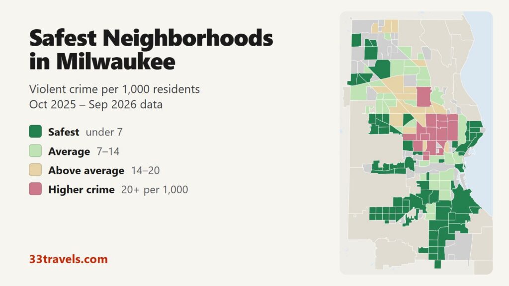
The safest neighborhoods in Milwaukee are on the far South Side, from Bay View and Tippecanoe along the lake west to Jackson Park, on the East Side around Murray Hill and Northpoint, and in a pocket of the far west side between North 76th Street and the Wauwatosa line. Between October 2025 and September 2026, 24 of the 82 neighborhoods with at least 2,500 residents recorded fewer than 5.1 violent crimes per 1,000 residents, half the city rate of 10.2. They are home to 22% of Milwaukee’s residents and recorded 5.6% of its violent crime.
Safest neighborhoods in Milwaukee: Fernwood, Tippecanoe, Town of Lake and Bay View on the southeast side near the lake. Jackson Park, Honey Creek Manor, Layton Park, Burnham Park and Fairview on the southwest side. Wilson Park, Morgandale, Castle Manor and Mitchell West around South 27th Street. Murray Hill, Northpoint, the Upper East Side, Yankee Hill and Brewer’s Hill on the East Side. Kops Park, Cooper Park, Golden Valley, Bluemound Heights, Johnson’s Woods and Washington Heights on the west side.
The South Side as a whole rates 4.9 violent crimes per 1,000 residents, the lowest of Milwaukee’s five parts of town. Citywide, violent crime fell 9% compared with the 12 months before. Two campus neighborhoods, Downer Woods at UW-Milwaukee and Marquette, show zero violent crimes because university police handle them, so they are left out of the ranking.
Map of the safest neighborhoods in Milwaukee
Dark green neighborhoods are the safest in Milwaukee and light green ones are close to the city average. Beige areas sit above the average, and rose areas have the highest violent crime rates. Grey areas are parks, the airport, industrial land or neighborhoods with fewer than 1,000 residents. The towns around the edge, including Shorewood, Wauwatosa and West Allis, have their own police. Use the buttons to zoom to a part of town, switch to Theft & robbery to see where property crime is highest, and tap or hover over a neighborhood for its numbers.
Violent crime per 1,000 residents
Thefts & robberies per area
Tap or hover a neighborhood to see its crime numbers.
Table of Contents
- Safest neighborhoods in Milwaukee
- Best neighborhoods in Milwaukee
- Safe areas in Milwaukee for tourists
- Is Bay View safe?
- Is the East Side safe?
- Low numbers that mislead
- Where crime is higher
- Safest suburbs of Milwaukee
- Tips for choosing a neighborhood
- How this map was made
- FAQ
Safest neighborhoods in Milwaukee
The table ranks the 15 neighborhoods of 2,500 or more residents with the lowest violent crime rates. Rates in neighborhoods of 3,000 people move by about 0.3 with each crime, so the top of the list is a group of safe places, not a strict order.
| Neighborhood | Alder district | Violent crimes per 1,000 | vs. city avg | Homicides | Aggravated assaults | Thefts + robberies |
|---|---|---|---|---|---|---|
| FernwoodDistrict 14 | District 14 | 0.7 | 0.1x | 0 | 2 | 9 |
| TippecanoeDistrict 14 | District 14 | 1.2 | 0.1x | 0 | 7 | 18 |
| Jackson ParkDistrict 11 | District 11 | 1.6 | 0.2x | 0 | 12 | 40 |
| Kops ParkDistrict 5 | District 5 | 1.7 | 0.2x | 0 | 3 | 20 |
| Wilson ParkDistrict 13 | District 13 | 1.8 | 0.2x | 0 | 5 | 22 |
| Murray HillDistrict 3 | District 3 | 2.0 | 0.2x | 0 | 7 | 93 |
| Honey Creek ManorDistrict 11 | District 11 | 2.0 | 0.2x | 0 | 4 | 8 |
| NorthpointDistrict 3 | District 3 | 2.2 | 0.2x | 0 | 4 | 47 |
| Golden ValleyDistrict 5 | District 5 | 2.3 | 0.2x | 0 | 5 | 17 |
| Cooper ParkDistrict 5 | District 5 | 2.4 | 0.2x | 0 | 7 | 14 |
| Yankee HillDistrict 4 | District 4 | 2.5 | 0.3x | 1 | 7 | 42 |
| Bluemound HeightsDistrict 10 | District 10 | 2.5 | 0.3x | 0 | 7 | 13 |
| Johnson's WoodsDistrict 10 | District 10 | 2.6 | 0.3x | 0 | 7 | 6 |
| Town Of LakeDistrict 13 | District 13 | 2.8 | 0.3x | 0 | 9 | 40 |
| FairviewDistrict 11 | District 11 | 2.8 | 0.3x | 1 | 7 | 41 |
Fernwood, Tippecanoe and the southeast side
Fernwood sits on the lake south of Bay View, between Oklahoma Avenue and the St. Francis line, and recorded 2 violent crimes in 12 months for a rate of 0.7. Tippecanoe, west of it between Morgan and Norwich avenues, is larger at 5,869 residents and rates 1.2. Its houses date mostly from the 1940s and 1950s. Town of Lake, south of Norwich Avenue toward Layton Avenue, rates 2.8.
Jackson Park and the southwest side
Jackson Park is the largest neighborhood in the top 15, with 8,680 residents between Lincoln and Morgan avenues and South 35th and 50th streets, and it rates 1.6. Its county park has a WPA-era lagoon and the city’s first outdoor pool, opened in 1932. Honey Creek Manor, just south across Morgan Avenue, rates 2.0, and Fairview, west of 60th Street, rates 2.8. Layton Park and Burnham Park, the bungalow and duplex blocks north of Jackson Park, rate 3.5 and 3.2.
Wilson Park and the South 27th Street corridor
Wilson Park, between Howard and Layton avenues west of I-94, is built around a 77-acre county park with a lagoon and playground, and rates 1.8. Morgandale to its north rates 3.0 with 9,779 residents. Castle Manor and Mitchell West, south of Layton Avenue, rate 3.3 and 4.6.
Murray Hill, Northpoint and the East Side
Murray Hill, north of North Avenue between Oakland and Downer avenues, rates 2.0. Its early 20th-century bungalows and duplexes house many UW-Milwaukee students. Northpoint, the lakefront neighborhood around the 1874 North Point Water Tower, rates 2.2, and the Upper East Side between Riverside Park and Lake Park rates 3.6. Theft is the exception here: Murray Hill recorded 91 thefts against 12 violent crimes.
Kops Park and the far west side
Kops Park, Cooper Park and Golden Valley form a block of residential neighborhoods between North 76th and 100th streets, from Center Street north to Capitol Drive. They rate 1.7, 2.4 and 2.3. Farther south, Bluemound Heights and Johnson’s Woods sit on either side of I-94 at Hawley Road and rate 2.5 and 2.6.
Best neighborhoods in Milwaukee
The safest neighborhoods are mostly residential areas away from Downtown. The best neighborhoods in Milwaukee for a visit, a family or a first apartment combine a low crime rate with parks, transit or a main street.
Best neighborhoods for visitors
Visitors are best placed in the Historic Third Ward, Yankee Hill or the Lower East Side. The Third Ward rates 4.2 on 2,156 residents and holds the Milwaukee Public Market, the RiverWalk, the Broadway Theatre Center and the Summerfest grounds at Henry Maier Festival Park. Yankee Hill, between State Street and Ogden Avenue on the lake side of Downtown, rates 2.5 and is a short walk from the Milwaukee Art Museum. The Lower East Side, with Brady Street and Prospect Avenue, rates 5.8. The free Hop streetcar links all three with the Intermodal Station, City Hall and the lakefront. Its M-Line runs from the Intermodal Station to Burns Commons on the Lower East Side, and its L-Line runs from the Third Ward to the lakefront.
Best neighborhoods for families
Families looking for low crime and space get both on the southwest and far west sides. Jackson Park and Wilson Park are built around county parks with pools and lagoons. Washington Heights, between North Avenue and Vliet Street on the Wauwatosa line at 60th Street, rates 3.6 and is known for its 1920s Arts and Crafts houses. In Bay View, Humboldt Park has playgrounds, sports fields and the summer Chill on the Hill concerts, and South Shore Park has a beach on the Oak Leaf Trail.
Best neighborhoods for young professionals
Bay View and the East Side combine low violent crime with bars, restaurants and walkable streets. Kinnickinnic Avenue is Bay View’s main street, with galleries, breweries and the Centraal Grand Cafe. On the East Side, North Avenue has the Oriental Theatre, a 1927 movie palace that still shows films, and Black Cat Alley’s murals. Brewer’s Hill, on the river north of Downtown, rates 3.7 and has converted factory lofts among its 1850s to 1920s houses. Walker’s Point has restaurants and nightlife south of Downtown, but it rates 10.8, above the city average.
Best affordable safe neighborhoods
The lowest housing costs among the safe neighborhoods are on the southwest and far west sides. Census Bureau estimates for 2020 to 2024 put median rent near $930 to $1,010 a month in Honey Creek Manor, Kops Park and Johnson’s Woods, and the median home value in Burnham Park near $135,000. The East Side lakefront and the Third Ward cost the most, with median rents of about $1,300 to $1,960. These figures are for census tracts, which do not follow neighborhood lines exactly.
Safe areas in Milwaukee for tourists
The lakefront and the Third Ward are the safest areas in Milwaukee for tourists. The Art Museum, Discovery World and Bradford Beach are in Lake Park, which has no residents and no rating. The Third Ward and Yankee Hill rate well below average. Downtown’s two other neighborhoods rate higher: Juneau Town, with City Hall and the Water Street bars, rates 8.0, and Kilbourn Town, with Fiserv Forum and the Deer District, rates 13.2. Those rates count residents only, while visitors add to the crowds on a game or concert night. Theft is the risk visitors meet most: Kilbourn Town recorded 199 thefts in 12 months.
Is Bay View safe?
Yes. Bay View is the largest neighborhood in Milwaukee, with 16,478 residents, and it recorded 49 violent crimes in 12 months for a rate of 3.0, under a third of the city’s. It runs from Bay Street south to Morgan Avenue between the lake and I-94. Theft is close to the city average per resident, with 195 thefts, most of them along Kinnickinnic Avenue where people park to eat and drink.
Is the East Side safe?
The East Side is one of the safest parts of Milwaukee for violent crime, with Murray Hill, Northpoint and the Upper East Side all in the top 25. The Lower East Side, the busiest part with Brady Street, rates 5.8, just over half the city rate, but recorded 259 thefts, the most of any neighborhood in the city. Brady Street had two shootings in June 2026, and the city ran a six-week safety pilot there afterward. Riverwest, across the river to the west, rates 7.6.
Low numbers that mislead
Downer Woods, which holds the UW-Milwaukee campus, and Marquette both show zero violent crimes. UW-Milwaukee Police and Marquette University Police handle crimes on campus, and their reports are not in MPD’s file. Mount Mary and Alverno, also campus areas, are low for the same reason.
The Third Ward and Brewer’s Hill rate well on violent crime but record more than twice the city’s thefts per resident, since their restaurants, hotels and bars draw people who do not live there. Lake Park and the airport have no rating at all because almost nobody lives in them.
Where crime is higher
Violent crime in Milwaukee is concentrated on the North Side, in a band from Holton Street west to about 60th Street between the Near West Side and Capitol Drive. Our areas to avoid in Milwaukee guide maps those 17 neighborhoods in detail. The North Side rates 14.9 per 1,000 as a whole, about three times the South Side.
Safest suburbs of Milwaukee
The suburbs report far less violent crime per resident than the city. The 11 other departments in the table together reported 1.57 violent crimes per 1,000 residents in 2025, against 11.45 for Milwaukee in the same FBI data. New Berlin, Franklin and Brookfield are the lowest of the larger suburbs. The North Shore villages are smaller and not in the table: Whitefish Bay reported 2 violent crimes in 2025, Shorewood 6 and Mequon 8, according to FBI data.
| City | Population | Violent crimes | Per 1,000 | Year |
|---|---|---|---|---|
| Milwaukee | 559,717 | 6,409 | 11.5 | 2025 |
| Racine | 78,032 | 326 | 4.2 | 2025 |
| West Allis | 59,618 | 109 | 1.8 | 2025 |
| Wauwatosa | 48,869 | 87 | 1.8 | 2025 |
| West Bend | 32,251 | 55 | 1.7 | 2025 |
| Waukesha | 71,542 | 82 | 1.2 | 2025 |
| Greenfield | 37,076 | 39 | 1.1 | 2025 |
| Menomonee Falls | 41,236 | 37 | 0.9 | 2025 |
| Oak Creek | 38,780 | 28 | 0.7 | 2025 |
| Brookfield | 41,216 | 26 | 0.6 | 2025 |
| Franklin | 36,675 | 19 | 0.5 | 2025 |
| New Berlin | 40,264 | 19 | 0.5 | 2025 |
Murder, rape, robbery and aggravated assault reported to the FBI by each agency, per 1,000 residents of the population the agency reports. Source: FBI Crime Data Explorer. Agencies that report no complete year are left out.
Tips for choosing a neighborhood
- Check the street, not only the neighborhood. Large areas such as Bay View and the Lower East Side have quieter and busier blocks.
- Switch the map to Theft & robbery before booking a car-dependent stay. Low violent crime and low car break-ins do not always go together.
- For a short visit, stay on the Hop line in the Third Ward, Yankee Hill or the Lower East Side to walk or ride to most sights.
- For a longer stay or a move, compare the southwest and far west sides, which combine low crime with the lowest rents.
- Call 9-1-1 for emergencies and 414-933-4444 for non-emergency police service in the city.
How this map was made
Crime counts come from the Milwaukee Police Department’s public NIBRS file for October 2025 through September 2026. Violent crime means murder, rape and other forcible sex offenses, robbery and aggravated assault, counted once per incident. Each crime is placed in one of the City of Milwaukee’s 190 official neighborhoods by its map coordinates, and the rate divides it by the 2020 Census population. The ranking includes neighborhoods with at least 2,500 residents and leaves out the campus areas named above. Crimes handled by the Milwaukee County Sheriff, by university police and by suburban departments are not in MPD’s records. The suburban table uses each department’s reports to the FBI’s Crime Data Explorer, and the housing figures come from the Census Bureau’s 2020-2024 American Community Survey.
We ranked the safest neighborhoods in Houston.
FAQ
What is the safest neighborhood in Milwaukee?
Among neighborhoods with at least 2,500 residents, Fernwood on the southeast lakefront has the lowest violent crime rate at 0.7 per 1,000 residents, followed by Tippecanoe at 1.2 and Jackson Park at 1.6. Jackson Park is the largest of the three, with 8,680 residents.
What part of Milwaukee is the safest?
The South Side. Its neighborhoods together recorded 4.9 violent crimes per 1,000 residents, the lowest of Milwaukee's five parts of town and under half the city rate of 10.2.
What are the best neighborhoods in Milwaukee to live in?
For low crime and lower housing costs, the southwest and far west sides: Jackson Park, Wilson Park, Kops Park and Washington Heights. For walkable streets with bars and restaurants, Bay View and the East Side around Murray Hill. All of them rate well under the city average for violent crime.
Where is the safest place to stay in Milwaukee as a tourist?
The Historic Third Ward, Yankee Hill and the Lower East Side. All three rate below the city average for violent crime, sit on the free Hop streetcar line and are within walking distance of the lakefront, the Public Market or Brady Street.
Is the Third Ward in Milwaukee safe?
Yes for violent crime: the Historic Third Ward rates 4.2 per 1,000 residents, well under the city rate. It has few residents and many visitors, so thefts are common: police recorded 61 in 12 months. Leave nothing in a parked car.
Is Wauwatosa safer than Milwaukee?
Yes. Wauwatosa reported 87 violent crimes in 2025 for about 48,000 residents, under a fifth of Milwaukee's rate in the same FBI data. Whitefish Bay, Shorewood and Mequon reported even fewer.
Why do some Milwaukee neighborhoods show zero crime?
Downer Woods, home of UW-Milwaukee, and Marquette show zero violent crimes because university police handle crimes on campus, and their reports are not in the Milwaukee Police Department's file. They are left out of the safest neighborhoods ranking.