
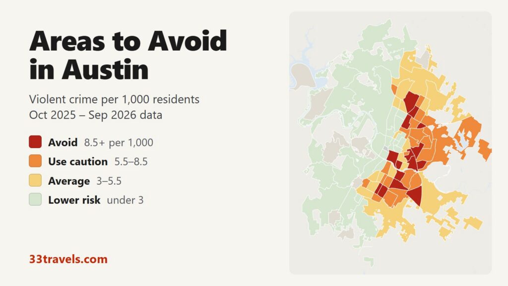
The areas to avoid in Austin run along I-35, from the Rundberg Lane area in North Austin through East Austin to Riverside, plus Downtown and the stretch of South Congress Avenue below Ben White Boulevard. Between October 2025 and September 2026, 15 neighborhoods recorded 8.5 or more violent crimes per 1,000 residents, about twice the city average of 4.1. Those neighborhoods are home to 12% of Austin’s residents and account for 31% of its violent crime, 39% of its robberies and 20 of its 50 homicides.
Neighborhoods to avoid in Austin: Downtown and East Cesar Chavez in the center. North Austin Civic Association, Georgian Acres, Highland and Coronado Hills in North Austin, around Rundberg Lane and US 183. Govalle, Johnston Terrace, MLK and Rosewood in East Austin. Riverside, Parker Lane and Southeast south of Lady Bird Lake. West Congress and East Congress along South Congress Avenue south of Ben White Boulevard.
Austin’s violent crime rate is about a third of Detroit’s or Baltimore’s, so “avoid” here means a neighborhood with roughly twice the Austin average. Most of the avoid areas are apartment districts with nothing that draws visitors. Downtown and East Cesar Chavez are the exceptions: few people live in them while many more work, drink and see shows there, which pushes up the rate per resident. Citywide, violent crime other than sexual assault fell 9% and homicides fell 19% compared with the 12 months before.
Austin safety map
Red areas are the places to avoid in Austin and orange areas call for caution. Grey areas outside the city are separate towns and suburbs with their own police, such as West Lake Hills, Rollingwood and Sunset Valley. Use the buttons to zoom to Downtown & Central, North, Northwest, East or South & West, and switch the map to Theft & robbery to see where car break-ins and shoplifting happen. Tap or hover over a neighborhood for its numbers.
Violent crimes per 1,000 residents
Thefts & robberies per area
Tap or hover a neighborhood to see its numbers.
Table of Contents
- Areas to avoid in Austin
- Areas to be careful in
- Is downtown Austin safe?
- Is 6th Street safe at night?
- Is East Austin safe?
- Is South Congress safe?
- Austin crime rate
- Car break-ins and car theft in Austin
- Safest neighborhoods to stay in Austin
- Round Rock, Cedar Park and the suburbs
- Austin safety tips for visitors
- How this map was made
- FAQ
Areas to avoid in Austin
These are the 15 neighborhoods with 8.5 or more violent crimes per 1,000 residents. Most are small, with 2,000 to 10,000 residents.
| Neighborhood | Council district | Violent crimes per 1,000 | vs. city avg | Homicides | Aggravated assaults | Thefts + robberies |
|---|---|---|---|---|---|---|
| DowntownDistrict 9 | District 9 | 20.8 | 5.1x | 5 | 127 | 1,611 |
| East Cesar ChavezDistrict 3 | District 3 | 13.9 | 3.4x | 1 | 35 | 420 |
| Georgian AcresDistrict 4 | District 4 | 11.3 | 2.7x | 2 | 62 | 189 |
| Coronado HillsDistrict 1 | District 1 | 11.0 | 2.7x | 0 | 20 | 54 |
| GovalleDistrict 3 | District 3 | 10.6 | 2.6x | 1 | 19 | 295 |
| Johnston TerraceDistrict 3 | District 3 | 10.3 | 2.5x | 1 | 12 | 143 |
| MLKDistrict 1 | District 1 | 10.0 | 2.4x | 1 | 26 | 133 |
| RosewoodDistrict 1 | District 1 | 9.7 | 2.4x | 0 | 35 | 156 |
| SoutheastDistrict 2 | District 2 | 9.4 | 2.3x | 0 | 23 | 117 |
| West CongressDistrict 3 | District 3 | 9.4 | 2.3x | 0 | 25 | 112 |
| HighlandDistrict 4 | District 4 | 9.0 | 2.2x | 1 | 24 | 297 |
| RiversideDistrict 3 | District 3 | 9.0 | 2.2x | 3 | 75 | 516 |
| East CongressDistrict 3 | District 3 | 8.9 | 2.2x | 0 | 20 | 197 |
| North Austin Civic AssociationDistrict 4 | District 4 | 8.7 | 2.1x | 4 | 153 | 520 |
| Parker LaneDistrict 3 | District 3 | 8.5 | 2.1x | 1 | 55 | 210 |
Downtown and East Cesar Chavez
Downtown has the highest rate in Austin, 20.8 violent crimes per 1,000 residents, and recorded 284 violent crimes and 1,517 thefts in 12 months, more of both than any other neighborhood. About 13,663 people live between Lady Bird Lake and Martin Luther King Jr. Boulevard, and the rate counts only them, not the office workers, hotel guests and bar crowds. A third of Downtown’s violent crime was recorded in the block group that holds the 6th Street bar strip, which has its own section.
East Cesar Chavez (13.9) lies across I-35 from Downtown, between Lady Bird Lake and East 7th Street. It holds the bars and restaurants of East 6th Street east of the interstate. The most common crime is theft (401 thefts against 68 violent crimes).
Rundberg: North Austin Civic Association, Georgian Acres, Highland and Coronado Hills
The area around Rundberg Lane, between North Lamar Boulevard and I-35, is the center of violent crime in North Austin. The North Austin Civic Association planning area, which covers most of it, recorded 236 violent crimes, the second-most in Austin after Downtown, and 153 aggravated assaults, the most of any area. With 27,088 residents, mostly in large apartment complexes, its rate is 8.7 per 1,000.
Georgian Acres (11.3) borders it to the south, between Rundberg Lane and US 183, and has the highest rate in North Austin. Highland (9.0), around the ACC Highland campus on the site of the old Highland Mall, and Coronado Hills (11.0), east of I-35 off Cameron Road, complete the cluster. Q2 Stadium and the Domain sit just past the area’s northwest corner, in North Burnet.
East Austin: Govalle, Johnston Terrace, MLK and Rosewood
Four neighborhoods east of the Downtown core rate avoid. Rosewood (9.7) runs along Rosewood Avenue and East 12th Street. MLK (10.0) follows Martin Luther King Jr. Boulevard east of Airport Boulevard. Govalle (10.6) and Johnston Terrace (10.3) sit further east along East 5th and East 7th Streets toward US 183. These are mixed neighborhoods of older houses, apartment complexes and new development.
Riverside, Parker Lane and Southeast
Riverside (9.0) is the long strip of apartment complexes along East Riverside Drive, south of Lady Bird Lake and east of I-35. With 13,321 residents it recorded 120 violent crimes and 3 homicides. Parker Lane (8.5) lies just south of it, around Parker Lane between Oltorf Street and Ben White Boulevard, and Southeast (9.4) covers the apartments and warehouses south of Ben White Boulevard east of I-35. The airport is further east and is not part of any of them.
West Congress and East Congress
West Congress (9.4) and East Congress (8.9) lie on either side of South Congress Avenue south of Ben White Boulevard, about 2 miles south of the shops and hotels that visitors know as SoCo. The two names cause confusion: the South Congress shopping strip is in Bouldin Creek and Travis Heights, which are covered in Is South Congress safe?
Areas to be careful in
These 21 neighborhoods have 5.5 to 8.5 violent crimes per 1,000 residents. Together with the avoid areas they hold 29% of residents and 58% of violent crime. Most are residential East and North Austin neighborhoods next to the avoid areas, such as Montopolis, Colony Park and St. John. Three are places visitors do go: Bouldin Creek, on the west side of South Congress; Mueller, built on the site of the old city airport; and Gateway, the shopping centers along Research Boulevard near the Domain, where only 1,542 people live and most crime is theft.
| Neighborhood | Council district | Violent crimes per 1,000 | vs. city avg | Homicides | Aggravated assaults | Thefts + robberies |
|---|---|---|---|---|---|---|
| GatewayDistrict 7 | District 7 | 8.4 | 2.0x | 0 | 7 | 310 |
| MontopolisDistrict 3 | District 3 | 8.1 | 2.0x | 0 | 72 | 336 |
| Bouldin CreekDistrict 9 | District 9 | 8.0 | 1.9x | 1 | 28 | 240 |
| McKinneyDistrict 2 | District 2 | 7.5 | 1.8x | 1 | 31 | 122 |
| North LamarDistrict 4 | District 4 | 7.5 | 1.8x | 2 | 33 | 111 |
| Colony Park / DeckerDistrict 1 | District 1 | 7.4 | 1.8x | 0 | 120 | 325 |
| MLK-183District 1 | District 1 | 7.3 | 1.8x | 1 | 40 | 116 |
| University HillsDistrict 1 | District 1 | 7.1 | 1.7x | 1 | 21 | 148 |
| Pecan Springs-SpringdaleDistrict 1 | District 1 | 7.0 | 1.7x | 0 | 29 | 94 |
| ChestnutDistrict 1 | District 1 | 6.8 | 1.7x | 0 | 14 | 58 |
| St. JohnDistrict 4 | District 4 | 6.6 | 1.6x | 0 | 39 | 238 |
| North LoopDistrict 9 | District 9 | 6.5 | 1.6x | 0 | 22 | 191 |
| St. EdwardsDistrict 3 | District 3 | 6.4 | 1.6x | 1 | 17 | 249 |
| SweetbriarDistrict 2 | District 2 | 6.4 | 1.6x | 0 | 27 | 250 |
| Franklin ParkDistrict 2 | District 2 | 6.2 | 1.5x | 1 | 71 | 242 |
| DawsonDistrict 3 | District 3 | 5.8 | 1.4x | 0 | 12 | 188 |
| WestgateDistrict 5 | District 5 | 5.8 | 1.4x | 1 | 13 | 78 |
| Pleasant ValleyDistrict 3 | District 3 | 5.7 | 1.4x | 0 | 44 | 259 |
| Windsor ParkDistrict 4 | District 4 | 5.7 | 1.4x | 0 | 42 | 406 |
| Heritage HillsDistrict 4 | District 4 | 5.5 | 1.3x | 1 | 26 | 212 |
| MuellerDistrict 9 | District 9 | 5.5 | 1.3x | 0 | 17 | 491 |
Is downtown Austin safe?
Yes. The crime visitors are most likely to meet downtown is theft. Downtown recorded 1,517 thefts and 115 stolen vehicles in 12 months, against 284 violent crimes. The Capitol grounds, Congress Avenue, the Convention Center area and the hotels along Lady Bird Lake are busy day and night.
Violent crime downtown happens late. 28% of the violent crimes in Downtown and the central neighborhoods around it happened between midnight and 4 a.m., with the peak at 2 a.m., when the bars close and crowds spill onto 6th Street and Rainey Street. Away from the bar blocks, take care at night on East 7th Street near I-35.
Is 6th Street safe at night?
Most of the risk on 6th Street comes after midnight, when the bar crowds peak. The census block group around East 6th Street and Trinity Street, the heart of the bar strip known as Dirty Sixth, recorded 94 violent crimes in 12 months, 33% of Downtown’s total and 2.4% of the whole city’s, along with 434 thefts. 40 of the violent crimes were aggravated assaults and 33 were robberies.
On March 1, 2026, a shooting outside a bar on West 6th Street left three people dead, including the gunman, and more than a dozen wounded. Since then the Austin Police Department has run weekend public safety zones on West 6th Street and on East 6th Street at Neches Street, from Friday to Sunday night.
To enjoy 6th Street safely, go earlier in the evening, keep your phone in a front pocket, stay out of arguments in the crowd and leave before 2 a.m. closing time. Rainey Street, a few blocks south, has the same closing-time crush.
Is East Austin safe?
Parts of it. Holly (4.9), Central East Austin (4.0) and Upper Boggy Creek (3.2) rate average. East Cesar Chavez, with the East 6th Street bars, rates avoid, as do Govalle, Johnston Terrace, MLK and Rosewood further east. District 1, which covers northeast Austin, has 6.7 violent crimes per 1,000 residents, against 0.9 in District 8 in the southwest.
Is South Congress safe?
Yes. The SoCo shopping and hotel strip, on South Congress Avenue between Lady Bird Lake and Oltorf Street, has more theft than violence. The west side of the avenue is Bouldin Creek, which rates caution at 8.0 per 1,000; its most common crime is theft, 229 thefts against 50 violent crimes. The east side is South River City, the Travis Heights area, at 3.2. Do not confuse SoCo with West Congress and East Congress, the avoid neighborhoods about 2 miles south along the same avenue.
Austin crime rate
Austin police recorded 3,992 violent crimes between October 2025 and September 2026, 4.1 per 1,000 residents, and 50 homicide victims. Violent crime other than sexual assault fell 9% compared with the 12 months before: aggravated assaults fell 10%, robberies 5% and homicides 19%. APD counted 55 homicides in calendar 2025, down from 66 in 2024.
Violence is concentrated along the I-35 corridor. District 3, which covers East Cesar Chavez, Riverside and Montopolis, has the highest violent crime rate of the 10 council districts, 7.9 per 1,000. Districts 8 and 10, which cover Southwest Austin, Westlake and Northwest Hills, have the lowest, 0.9 and 1.1. The northwest of the city, from Northwest Hills to Avery Ranch, has no area above the city average.
Car break-ins and car theft in Austin
Car break-ins are the crime visitors are most likely to face in Austin. Police recorded 6,209 thefts from vehicles in 12 months, 29% of all thefts, and 3,316 stolen vehicles. Break-ins happen all over the city, and the areas with the most are not avoid areas: the most were in Great Hills / Balcones, followed by Gracywoods / Parmer Lane. Dove Springs / Onion Creek had the most stolen vehicles. Both crimes are falling: thefts from vehicles dropped 19% and vehicle thefts 26% in a year. Leave nothing visible in the car, including bags and charging cables, and use staffed garages downtown.
Safest neighborhoods to stay in Austin
The lowest-rate neighborhoods near the places visitors go are Old West Austin, Zilker, Hyde Park and the neighborhoods around UT. Old West Austin and Zilker sit between Downtown and Zilker Park. Barton Hills holds Zilker Park and Barton Springs Pool. Hyde Park, North University and West University surround the UT campus, which is patrolled by UT Police. South River City (Travis Heights) is the residential side of South Congress.
| Neighborhood | Council district | Violent crimes per 1,000 | vs. city avg | Homicides | Aggravated assaults | Thefts + robberies |
|---|---|---|---|---|---|---|
| Old West AustinDistrict 9 | District 9 | 2.3 | 0.6x | 0 | 9 | 149 |
| ZilkerDistrict 5 | District 5 | 2.1 | 0.5x | 0 | 15 | 223 |
| Barton HillsDistrict 5 | District 5 | 2.8 | 0.7x | 0 | 13 | 311 |
| Hyde ParkDistrict 9 | District 9 | 1.6 | 0.4x | 1 | 6 | 136 |
| North UniversityDistrict 9 | District 9 | 1.9 | 0.5x | 0 | 5 | 110 |
| West UniversityDistrict 9 | District 9 | 1.5 | 0.4x | 0 | 13 | 524 |
| South River CityDistrict 9 | District 9 | 3.2 | 0.8x | 0 | 10 | 193 |
| South LamarDistrict 5 | District 5 | 3.3 | 0.8x | 1 | 20 | 288 |
| North BurnetDistrict 7 | District 7 | 3.5 | 0.9x | 0 | 21 | 588 |
Downtown hotels sit in the highest-rate neighborhood, where the risk is theft and late-night trouble near 6th Street. North Burnet, which holds the Domain and Q2 Stadium, rates 3.5 per 1,000, below the city average.
Round Rock, Cedar Park and the suburbs
The suburbs around Austin have lower violent crime rates than the city. The 8 suburban police departments in the table together reported 1.53 violent crimes per 1,000 residents in 2025, against 4.23 for Austin in the same FBI data. San Marcos, a college town 30 miles south, matches Austin’s rate. Leander, Hutto and Cedar Park rate lowest.
| City | Population | Violent crimes | Per 1,000 | Year |
|---|---|---|---|---|
| San Marcos | 75,924 | 322 | 4.2 | 2025 |
| Austin | 1,000,639 | 4,229 | 4.2 | 2025 |
| Pflugerville | 67,159 | 125 | 1.9 | 2025 |
| Georgetown | 111,743 | 167 | 1.5 | 2025 |
| Kyle | 71,858 | 98 | 1.4 | 2025 |
| Round Rock | 139,331 | 175 | 1.3 | 2025 |
| Cedar Park | 78,469 | 71 | 0.9 | 2025 |
| Hutto | 47,401 | 40 | 0.8 | 2025 |
| Leander | 95,840 | 56 | 0.6 | 2025 |
Murder, rape, robbery and aggravated assault reported to the FBI by each agency, per 1,000 residents of the population the agency reports. Source: FBI Crime Data Explorer. Agencies that report no complete year are left out.
Austin safety tips for visitors
- Leave 6th Street and Rainey Street before the 2 a.m. closing rush, and take a rideshare from a side street rather than the crowded corners.
- Lock your car and leave nothing in sight, especially at trailheads, shopping centers and hotel lots.
- Keep your phone and wallet in a front pocket in crowds at 6th Street, festivals and Longhorns games.
- Stay Downtown away from 6th Street, on South Congress, in Zilker or Hyde Park, or near the Domain.
- Call 9-1-1 for emergencies and 3-1-1 (or 512-974-2000) to report a crime that is not an emergency.
How this map was made
Crime counts come from the Austin Police Department’s public NIBRS offense records for October 2025 through September 2026. Violent crime means murder, rape and other forcible sex offenses, robbery and aggravated assault. Crimes against persons are counted once per victim, the FBI rule. APD publishes the census block group of each crime, not its address, so neighborhood counts are shared out among the blocks of each block group in proportion to their 2020 Census population. Population is the 2020 Census count by block. The suburban table uses each department’s reports to the FBI’s Crime Data Explorer.
The neighborhoods are the City of Austin’s neighborhood planning areas. They cover the central half of the city, so the rest is grouped into larger areas by council district, such as Circle C / Southwest Austin. The tiers are Avoid (8.5 or more violent crimes per 1,000 residents), Use caution (5.5 to 8.5), Average (3 to 5.5) and Lower risk (under 3). Crimes handled by UT Police on campus and by the Texas Department of Public Safety at the Capitol are not in APD’s records. The theft layer counts thefts and robberies, not rates.
We built the same map for the areas to avoid in Chicago, the areas to avoid in New York City, the areas to avoid in San Francisco, the areas to avoid in Los Angeles, the areas to avoid in Miami, the areas to avoid in Atlanta, the areas to avoid in Baltimore and the areas to avoid in Detroit.
FAQ
Is Austin safe to visit?
Yes. Austin had 4.1 violent crimes per 1,000 residents in the 12 months to September 2026, about a third of Detroit's rate. The neighborhoods with the most violence are apartment districts along I-35 and around Rundberg Lane that visitors have little reason to go to. The main risks for visitors are car break-ins and late-night trouble on 6th Street.
What areas of Austin should you avoid?
The 15 neighborhoods with 8.5 or more violent crimes per 1,000 residents are Downtown and East Cesar Chavez; North Austin Civic Association, Georgian Acres, Highland and Coronado Hills around Rundberg Lane; Govalle, Johnston Terrace, MLK and Rosewood in East Austin; Riverside, Parker Lane and Southeast south of Lady Bird Lake; and West Congress and East Congress south of Ben White Boulevard. Downtown rates high per resident because few people live there and many visit.
What is the most dangerous neighborhood in Austin?
Downtown has the highest violent crime rate, 20.8 per 1,000 residents, because of the 6th Street bar crowds and its small resident population. Outside Downtown, East Cesar Chavez (13.9) and Georgian Acres (11.3) rate highest, and the North Austin Civic Association area around Rundberg Lane recorded the most aggravated assaults.
Is Rundberg dangerous?
The Rundberg Lane area, between North Lamar Boulevard and I-35, has the highest concentration of violent crime in North Austin. The North Austin Civic Association area recorded 236 violent crimes in 12 months, a rate of 8.7 per 1,000, about twice the city average. Georgian Acres, just south of it, rates 11.3.
Is Riverside in Austin safe?
Riverside rates avoid at 9.0 violent crimes per 1,000 residents, with 120 violent crimes in 12 months. It is the apartment corridor along East Riverside Drive, south of Lady Bird Lake and east of I-35, between Downtown and the airport.
Where is the safest place to stay in Austin?
Old West Austin (2.3 violent crimes per 1,000 residents), Zilker (2.1) and Hyde Park (1.6) have the lowest rates of the neighborhoods close to Downtown.
Are Round Rock and the Austin suburbs safer than Austin?
Yes. Round Rock, Cedar Park, Leander and Georgetown all reported less than half of Austin's violent crime rate in 2025. San Marcos is the exception, at about the same rate as Austin.
