Oceania’s island arcs and volcanic chains are the product of active plate boundaries and hotspots, shaping everything from coastlines to local cultures. Many communities live close to vents that can shift between quiet, steaming, and eruptive phases with little warning.
There are 19 Active volcanoes in Oceania, ranging from Ambae (Manaro Voui) to Yasur. For each entry, information is organized as Country/Archipelago, Coordinates (lat, lon), Last eruption & status — you’ll find below.
How current is the eruption and status information?
Eruption status can change rapidly; the list compiles recent records from regional observatories and global monitoring agencies, but always check the local volcano observatory or the Global Volcanism Program for the latest bulletins and alerts before making plans.
Is it safe to visit these volcanoes and what precautions should I take?
Some sites are accessible with guides while others have exclusion zones; before visiting check official advisories, follow park or community rules, use experienced guides, keep distance from vents, and be prepared for ash, gas, or sudden access restrictions.
Active Volcanoes in Oceania
| Name | Country/Archipelago | Coordinates (lat, lon) | Last eruption & status |
|---|---|---|---|
| Hunga Tonga-Hunga Haʻapai | – Tonga (Tongatapu arc) | -20.54, -175.38 | 2022 – Catastrophic eruption and tsunami |
| Whakaari / White Island | New Zealand (Bay of Plenty) | -37.52, 177.18 | 2019 – Deadly phreatic eruption |
| Ambae (Manaro Voui) | Vanuatu (Aoba Island) | -15.38, 167.85 | 2018 – Large eruptions prompted evacuations |
| Yasur | Vanuatu (Tanna) | -19.53, 169.44 | ongoing – Persistent Strombolian activity |
| Ambrym (Benbow/Marum) | Vanuatu (Ambrym) | -15.36, 168.16 | ongoing – Persistent lava-lake activity at vents |
| Lopevi | Vanuatu (Lopevi) | -16.92, 168.55 | 2007 – Intermittent ash eruptions |
| Ulawun | Papua New Guinea (New Britain) | -5.05, 151.35 | 2019 – Major explosive eruption and ash plumes |
| Manam | Papua New Guinea (Manam Island) | -4.08, 145.03 | 2018 – Frequent explosive activity and evacuations |
| Tavurvur (Rabaul) | Papua New Guinea (New Britain) | -4.25, 152.18 | 1994 – Major eruption destroyed much of Rabaul town |
| Bagana | Papua New Guinea (Bougainville) | -6.11, 155.20 | ongoing – Frequent effusive eruptions producing lava flows |
| Langila | Papua New Guinea (New Britain) | -4.19, 151.95 | 2018 – Frequent ash-producing eruptions |
| Raoul Island | New Zealand (Kermadec Islands) | -29.26, -177.92 | 2006 – Phreatic eruptions and recurrent unrest |
| Ruapehu | New Zealand (North Island) | -39.28, 175.57 | 2007 – Crater‑lake eruptions and lahar hazard |
| Tongariro | New Zealand (North Island) | -39.11, 175.64 | 2012 – Small eruptions at Te Māri craters |
| Ngauruhoe | New Zealand (Mount Ngauruhoe) | -39.16, 175.63 | 1975 – Dormant since mid‑20th century but Holocene activity |
| Kavachi | Solomon Islands (New Georgia region) | -9.04, 157.97 | 2015 – Submarine eruptions forming ephemeral islands |
| Tinakula | Solomon Islands (Santa Cruz Islands) | -10.80, 165.45 | 2012 – Intermittent Strombolian activity |
| McDonald Island | Australia (Heard & McDonald Islands) | -53.06, 72.58 | 2014 – Subaerial eruptions changing island morphology |
| Big Ben (Mawson Peak) | Australia (Heard Island) | -53.10, 73.53 | ongoing – Recurrent eruptive episodes on Heard Island |
Images and Descriptions
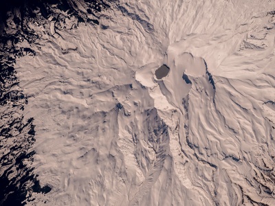
Hunga Tonga-Hunga Haʻapai
Late 2022’s colossal eruption produced a devastating tsunami and global atmospheric effects. Major hazard to Tonga; not a tourist site now, but central to studies of explosive magma‑water interactions and tsunami generation.
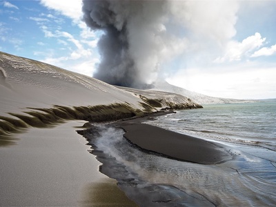
Whakaari / White Island
A small, frequently active island volcano popular with tourists until the fatal 2019 phreatic blast. Ongoing fumarolic activity makes it hazardous; guided visits now heavily regulated and research into gas hazard continues.
Ambae (Manaro Voui)
Ambae’s 2017–2018 eruptions blanketed the island with ash and forced evacuations. A broad caldera with explosive potential; ash and lahar risks make travel and settlement hazardous during unrest.
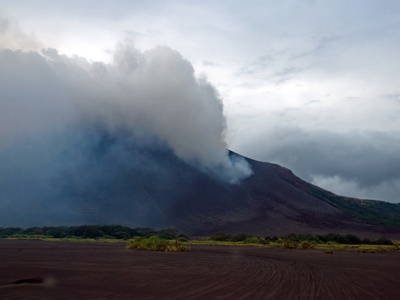
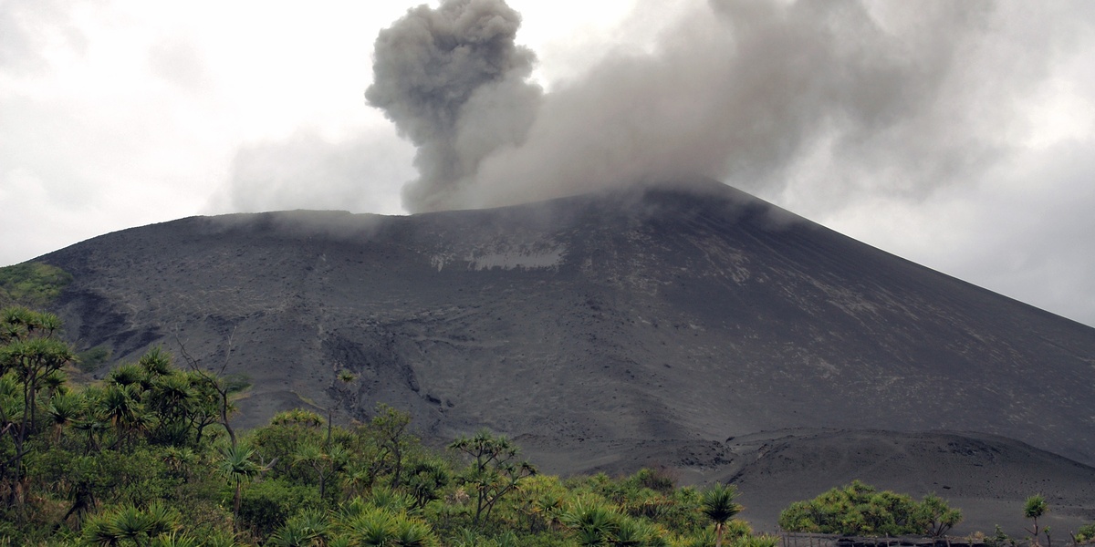
Yasur
One of the world’s most accessible continuously erupting volcanoes, Yasur offers reliable Strombolian displays. Popular for guided night visits, but sudden ballistic ejecta and ash make safety briefings and local guides essential.

Ambrym (Benbow/Marum)
Ambrym hosts long‑lived lava lakes at Marum and Benbow craters. Remote island risk: ash, lava flows, and gas. Fascinating for volcanologists but logistically challenging and hazardous for casual visitors.
Lopevi
Lopevi is an uninhabited volcanic cone with intermittent ash eruptions that forced evacuations in the past. Visible from nearby islands; ashfall and explosive bursts present hazards to nearby communities and boats.
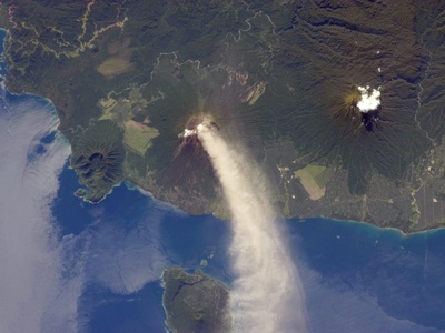
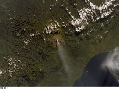
Ulawun
Ulawun is one of PNG’s most explosive volcanoes with large Plinian eruptions. Significant ashfall, pyroclastic flows and lahars threaten nearby villages; not tourist-friendly during unrest but intensively monitored.
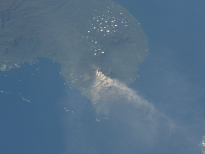
Manam
Manam produces regular explosive eruptions and ash plumes that have repeatedly displaced island communities. Close-up visits are unsafe; it’s a priority site for hazard response and volcanic island research.
Tavurvur (Rabaul)
Tavurvur’s 1994 eruption buried Rabaul in ash and forced relocation. The vent remains capable of explosive eruptions and occasional activity; Rabaul’s experience is a key case study in urban volcanic hazards.
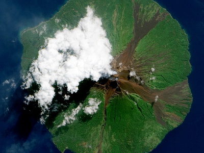
Bagana
Bagana is a very active, remote lava‑flowing volcano that frequently emits ash and lava. Limited access and persistent activity make it a notable hazard for local communities and a subject of effusive eruption studies.
Langila
Langila regularly produces ash plumes that affect nearby settlements and aviation. The volcano’s frequent smaller eruptions make it important for local monitoring and regional ash hazard planning.
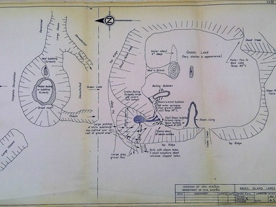
Raoul Island
Raoul experiences intermittent phreatic eruptions and geothermal unrest; remote location means eruptions threaten researchers and visitors rather than populated areas. Important for studying hydrothermal‑driven eruptions.
Ruapehu
Ruapehu is an active stratovolcano with crater‑lake activity that can trigger lahars affecting ski fields and valley communities. Monitored continuously; popular for recreation when quiet but risky during unrest.
Tongariro
Tongariro’s 2012 eruptions produced ash and ballistic blocks near popular hiking routes. Well‑known national park volcano with clear hazard management and popular trails—read advisories before visiting.
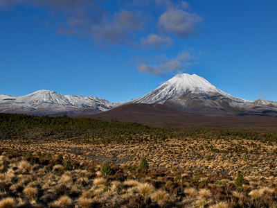
Ngauruhoe
Formerly very active and visually iconic (often mistaken for Mount Doom). Dormant since 1975 but still Holocene‑active; hikers should follow local guidance as eruptions remain possible.
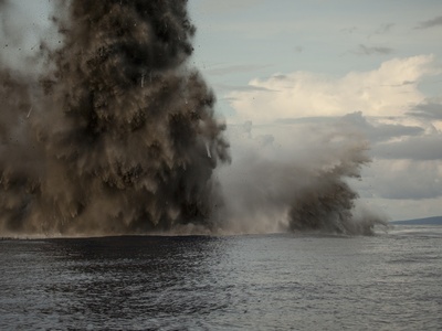
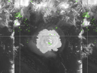
Kavachi
Kavachi is an active submarine volcano that occasionally builds temporary islands and produces large plumes. Dangerous for ships and research vessels; spectacular for remote monitoring but not safe for travel.
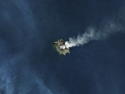
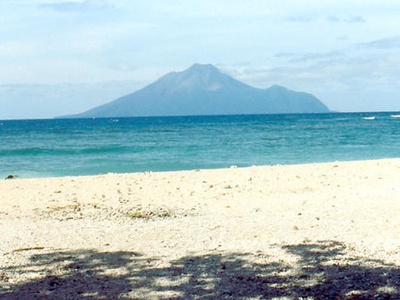
Tinakula
Tinakula is a small volcanic island with intermittent explosive activity; typically uninhabited. Ash and ejecta hazards limit visits, but it’s an interesting feature for regional volcanic monitoring.
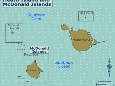
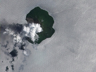
McDonald Island
McDonald Island’s recent eruptions produced new lava flows and changed shoreline extent. Remote and protected, it’s important for subantarctic volcanology but inaccessible to tourists.
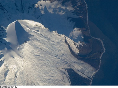
Big Ben (Mawson Peak)
Big Ben hosts Mawson Peak, with frequent eruptive episodes shaping Heard Island. Extreme remoteness means hazards affect scientific expeditions, not tourists; notable for polar volcanology research.