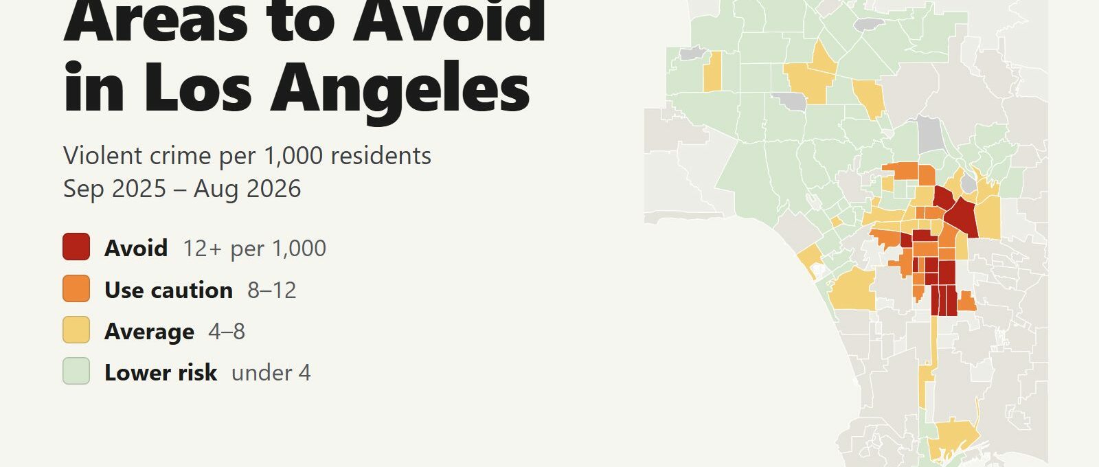
The areas to avoid in Los Angeles are Skid Row in Downtown, Westlake around MacArthur Park and a cluster of South LA neighborhoods along Vermont Avenue. Between September 2025 and August 2026, 11 of the city’s 109 residential neighborhoods recorded 12 or more violent crimes per 1,000 residents, about double the city average of 5.9. Those neighborhoods are home to 11% of Angelenos and account for 36% of the city’s homicides and 39% of its shooting victims.
Areas to avoid: Downtown (Skid Row) and Westlake in central Los Angeles. Vermont-Slauson, Vermont Knolls, Vermont Vista, Green Meadows, Broadway-Manchester, Florence, Chesterfield Square, Exposition Park and Leimert Park in South LA.
Hollywood falls just below the line at 11.4 per 1,000, and its violence peaks after midnight, when the clubs close. The Westside (2.5 per 1,000) and the San Fernando Valley (3.3) have the lowest rates in the city, and Santa Monica, Beverly Hills and Pasadena are separate cities with rates near or below LA’s. The most common crime visitors face is a car break-in: 18,136 in 12 months, a third of all thefts. From January to August 2026, violent crime fell 4% and homicides fell 7% compared with the same months of 2025.
Los Angeles safety map
Red areas are the ones to avoid and orange areas call for caution. Grey areas are parks, reservoirs and flood basins with few or no residents. The pale shapes are separate cities, such as Santa Monica, Beverly Hills, Inglewood and Compton, which have their own police and are compared in a table further down. Use the region buttons to zoom in, and switch the map to Theft & robbery to see where thefts and car break-ins happen. Tap or hover over a neighborhood for its numbers.
Violent crimes per 1,000 residents
Thefts & robberies per area
Tap or hover a neighborhood to see its numbers.
Table of Contents
- Areas to avoid in Los Angeles
- Where is Skid Row?
- Areas to be careful in
- Is Hollywood safe?
- Is Venice Beach safe?
- Car break-ins in Los Angeles
- Is the LA Metro safe?
- Compton, Inglewood and nearby cities
- Safest neighborhoods to stay in Los Angeles
- LA safety tips for visitors
- How this map was made
- FAQ
Areas to avoid in Los Angeles
These are the 11 neighborhoods with at least double the city’s violent crime rate. Each one is a large area with thousands of residents, and its violence is concentrated on particular blocks. Visitors go to Downtown, Exposition Park and Leimert Park, and pass through Westlake on the Metro. There is no visitor reason to walk through the others, especially at night.
| Neighborhood | Region | Violent crimes per 1,000 | vs. city avg | Homicides | Shooting victims | Thefts + robberies |
|---|---|---|---|---|---|---|
| Downtown | Central | 38.4 | 6.5x | 35 | 70 | 6,316 |
| Vermont-Slauson | South LA | 17.1 | 2.9x | 6 | 22 | 578 |
| Chesterfield Square | South LA | 15.7 | 2.7x | 1 | 2 | 113 |
| Vermont Knolls | South LA | 14.8 | 2.5x | 5 | 13 | 277 |
| Green Meadows | South LA | 14.3 | 2.4x | 4 | 42 | 588 |
| Vermont Vista | South LA | 13.7 | 2.3x | 6 | 22 | 357 |
| Florence | South LA | 13.4 | 2.3x | 2 | 24 | 675 |
| Westlake | Central | 13.3 | 2.3x | 10 | 31 | 2,004 |
| Exposition Park | South LA | 13.1 | 2.2x | 1 | 12 | 580 |
| Leimert Park | South LA | 12.4 | 2.1x | 0 | 2 | 436 |
| Broadway-Manchester | South LA | 12.0 | 2.0x | 6 | 21 | 359 |
Downtown
Downtown has the highest violent crime rate in Los Angeles, 38.4 per 1,000 residents, 6.5 times the city average. It recorded 2,555 violent crimes, 35 homicides and 70 shooting victims, more than any other neighborhood. Skid Row, a 50-block area east of Main Street, accounts for 38.7% of Downtown’s violent crime. Even without Skid Row, Downtown’s rate would be the highest in the city. Hundreds of thousands of office workers, fans and visitors pass through a neighborhood of 66,555 residents, so the per-resident rate overstates the risk for any one visitor.
Downtown also holds Union Station, Olvera Street, Little Tokyo, Grand Central Market, Walt Disney Concert Hall, The Broad, Crypto.com Arena and the hotels around L.A. Live. Those places are busy from morning to evening and safe to visit. Stay out of the blocks between Main and Alameda Streets from 3rd to 7th Street, use a rideshare between Downtown districts after dark, and keep your phone in a front pocket on crowded sidewalks. Downtown had 2,560 car break-ins in 12 months, the most in the city, so park in a staffed garage.
South LA: the Vermont Avenue corridor
Seven of the 11 are side by side in South LA, along Vermont Avenue and the Harbor Freeway between Exposition Park and the 105 Freeway. Vermont-Slauson has the highest rate outside Downtown, 17.1 per 1,000. Green Meadows recorded 42 shooting victims, the second-highest count in the city. Vermont Knolls (14.8), Vermont Vista (13.7), Broadway-Manchester (12.0), Florence (13.4) and Chesterfield Square (15.7) complete the cluster. None of them has anything that draws visitors. The 110 Freeway, which connects Downtown with the Harbor and the cruise port in San Pedro, runs through the middle of them. Stay on the freeway.
Westlake and MacArthur Park
Westlake (13.3 per 1,000) is the area around MacArthur Park, just west of Downtown, with 106,288 residents. It recorded 10 homicides, 31 shooting victims and 2,004 thefts and robberies, among the most in the city. Visitors meet it in two ways: Langer’s Deli, at 7th Street and Alvarado facing the park, and the Westlake/MacArthur Park station on the B and D Lines, which trains from Downtown to Hollywood and Koreatown pass through. Go to Langer’s at lunchtime. Stay on the train, and don’t cross the park after dark.
Exposition Park and Leimert Park
Exposition Park (13.1 per 1,000) is named for the park at its northern edge, home to the Natural History Museum, the California Science Center with the Space Shuttle Endeavour, the Lucas Museum of Narrative Art (opened in September 2026), the Los Angeles Memorial Coliseum and BMO Stadium. About three quarters of the neighborhood’s violent crime happens in the residential blocks south and west of the park. Go for the museums or a game, take the E Line to Expo Park/USC, which stops at the park’s edge, and leave with the crowd the same way.
Leimert Park (12.4) has Leimert Park Village, the center of Black arts, jazz and food in Los Angeles, and a K Line station on Crenshaw Boulevard. It has 12,396 residents, so a small number of crimes raises its rate. Visit the village by day or for an evening event, and park on the main streets.
Where is Skid Row?
Skid Row is the part of Downtown Los Angeles bounded by 3rd Street to the north, 7th Street to the south, Alameda Street to the east and Main Street to the west. It has the largest concentration of homeless people in the United States, living in shelters, single-room hotels and tents along the sidewalks. In the 12 months to August 2026, police recorded 988 violent crimes and 17 homicides inside those four streets: 38.7% of Downtown’s violent crime and 4.3% of the city’s, in an area of about 50 blocks.
Skid Row sits between the places visitors go. Little Tokyo is to the north, the Arts District to the east across Alameda Street, and the Fashion District and the Flower Market to the south. Walking between them on 4th, 5th or 6th Street takes you through it.
- Take a rideshare or the A and E Lines between Little Tokyo/Arts District station and the rest of Downtown instead of walking through Skid Row.
- If you drive through, keep the doors locked and the windows up.
- Hotels on Main Street between 4th and 7th Streets sit on Skid Row’s western edge. Check the address before you book.
Areas to be careful in
Another 13 neighborhoods have between 8 and 12 violent crimes per 1,000 residents. Most are in South LA, with Hollywood, East Hollywood and Pico-Union in central Los Angeles.
| Neighborhood | Region | Violent crimes per 1,000 | vs. city avg | Homicides | Shooting victims | Thefts + robberies |
|---|---|---|---|---|---|---|
| Hollywood | Central | 11.4 | 1.9x | 8 | 13 | 2,649 |
| Harvard Heights | Central | 11.2 | 1.9x | 1 | 3 | 376 |
| Harvard Park | South LA | 10.9 | 1.9x | 1 | 1 | 181 |
| Gramercy Park | South LA | 10.5 | 1.8x | 2 | 8 | 138 |
| Historic South-Central | South LA | 10.2 | 1.7x | 4 | 30 | 819 |
| Vermont Square | South LA | 10.2 | 1.7x | 3 | 8 | 565 |
| East Hollywood | Central | 9.4 | 1.6x | 2 | 7 | 1,023 |
| South Park | South LA | 9.4 | 1.6x | 2 | 19 | 355 |
| Manchester Square | South LA | 9.0 | 1.5x | 2 | 7 | 128 |
| Baldwin Hills/Crenshaw | South LA | 8.9 | 1.5x | 1 | 6 | 487 |
| Pico-Union | Central | 8.7 | 1.5x | 1 | 7 | 496 |
| Watts | South LA | 8.7 | 1.5x | 4 | 23 | 502 |
| Hyde Park | South LA | 8.6 | 1.5x | 6 | 16 | 412 |
Crenshaw, Hyde Park and Watts
Baldwin Hills/Crenshaw (8.9 per 1,000) has the Baldwin Hills Crenshaw Plaza mall and borders the Kenneth Hahn State Recreation Area, whose hilltop trails look out over the whole basin. Hyde Park (8.6) sits along the K Line south toward Inglewood. Watts (8.7) has the Watts Towers, Simon Rodia’s mosaic towers, a short walk from the A Line’s 103rd Street/Watts Towers station. Visit all three during the day.
Pico-Union and East Hollywood
Pico-Union (8.7) lies between Westlake and the 10 Freeway, south of Koreatown. East Hollywood (9.4) takes in Little Armenia, Thai Town and the hospitals on Sunset Boulevard, between Hollywood and Silver Lake. Both are busy in the daytime and have no reason to draw visitors at night.
Is Hollywood safe?
Hollywood is safe by day and early evening, when the Walk of Fame, the TCL Chinese Theatre and the Dolby Theatre are crowded. Its violent crime rate is 11.4 per 1,000, just below the avoid tier, and it recorded 2,649 thefts and robberies, the second-highest count in the city after Downtown. Hollywood Boulevard and Vine Street, the two streets of the Walk of Fame, account for about 30% of them.
Violence in Hollywood peaks late at night. The three hours from midnight to 3 a.m., when the clubs on Hollywood Boulevard and Cahuenga close, saw 22% of its violent crimes, and the peak hour is 2 a.m. Thefts and robberies peak at 11 p.m.
- Costumed characters on the Walk of Fame expect a tip for photos. Agree on the amount first or skip it.
- Don’t take a CD, bracelet or “free” gift that someone pushes into your hand. The seller will demand money for it.
- Book bus tours online from the company itself rather than from a street seller on Hollywood Boulevard.
- Leave by 11 p.m. or take a rideshare from the hotel door. The B Line’s Hollywood/Highland station connects Hollywood with Downtown and Universal City.
- Runyon Canyon (Hollywood Hills West, 2.2 per 1,000) and the Hollywood Bowl (Hollywood Hills, 2.3) are in the hills above Hollywood, with low rates. Their parking lots are a target for car break-ins.
Is Venice Beach safe?
Venice is safe during the day. Its violent crime rate is 7.3 per 1,000, a little above the city average of 5.9, and it recorded 4 homicides in 12 months. The boardwalk, Muscle Beach and the skate park are crowded from late morning to sunset. After dark the boardwalk empties, and that is the time to leave it. Only about 1 in 12 of Venice’s 823 thefts and robberies happened on the boardwalk itself. The rest were on the streets behind it, including Abbot Kinney Boulevard and the canals, many of them from parked cars.
Car break-ins in Los Angeles
Police recorded 18,136 thefts from vehicles in 12 months, 33.7% of all thefts in the city. Downtown had the most (2,560), followed by Koreatown (764), Hollywood (668), North Hollywood (488) and Westlake (466). Sherman Oaks and Silver Lake, which have low violent crime rates, are both in the top 10.
- Leave nothing visible in the car: no bags, jackets, charging cables or loose change.
- Put luggage in the trunk before you arrive, not after you park. Thieves watch parking lots at trailheads, beaches and the Walk of Fame.
- Use staffed or gated garages in Downtown and Hollywood.
- Take your passport, laptop and camera with you, even for a short stop.
Is the LA Metro safe?
Police recorded 549 violent crimes on Metro trains, buses and stations inside the city in 12 months, 2.4% of the city’s total, and 214 robberies. Most visitors use three lines: the B Line between Union Station, Hollywood and Universal City, the E Line between Downtown, Exposition Park and Santa Monica, and the A Line to Long Beach and Pasadena.
- Ride in the first car, next to the train operator.
- Move to another car if someone is smoking, fighting or harassing riders.
- Report problems with the LA Metro Transit Watch app or to Metro’s uniformed transit ambassadors on trains and platforms.
- Pay with a TAP card, either the plastic card or the one in your phone’s wallet. Don’t buy a fare from someone at the gates.
- After 10 p.m., take a rideshare instead.
Compton, Inglewood and nearby cities
Compton, Inglewood, Long Beach, Santa Monica, Beverly Hills and West Hollywood are separate cities with their own police or the Los Angeles County Sheriff, so they are not on the neighborhood map. The table uses the California Department of Justice’s 2025 crime figures for every city, including Los Angeles, so the rates compare directly with each other. The state counts crimes differently from the LAPD data on the map, which is why its rate for Los Angeles (6.7 per 1,000) differs from the map’s 5.9.
| City | Police | Population | Violent crimes per 1,000 | Homicides |
|---|---|---|---|---|
| Compton | LA County Sheriff (contract) | 94,182 | 11.9 | 18 |
| West Hollywood | LA County Sheriff (contract) | 35,418 | 7.4 | 1 |
| Lancaster | LA County Sheriff (contract) | 177,170 | 7.2 | 18 |
| Lynwood | LA County Sheriff (contract) | 66,675 | 7.0 | 4 |
| Los Angeles | LAPD | 3,839,536 | 6.7 | 225 |
| Inglewood | Inglewood PD | 106,645 | 6.5 | 5 |
| Culver City | Culver City PD | 40,640 | 6.4 | 0 |
| Long Beach | Long Beach PD | 462,968 | 6.0 | 29 |
| Santa Monica | Santa Monica PD | 93,876 | 6.0 | 4 |
| Hawthorne | Hawthorne PD | 85,865 | 5.5 | 10 |
| Palmdale | LA County Sheriff (contract) | 166,554 | 4.7 | 4 |
| South Gate | South Gate PD | 93,411 | 4.6 | 5 |
| Carson | LA County Sheriff (contract) | 92,206 | 4.3 | 2 |
| Pasadena | Pasadena PD | 141,466 | 4.1 | 1 |
| Beverly Hills | Beverly Hills PD | 32,209 | 3.9 | 0 |
| Burbank | Burbank PD | 105,713 | 3.3 | 0 |
| Glendale | Glendale PD | 193,810 | 2.2 | 1 |
Violent crime = homicide, rape, robbery and aggravated assault as each department reports it to the state, 2025. Population: January 1, 2025 estimates. Sheriff contract cities are reported by the LA County Sheriff's Department under the city name. Sources: California DOJ OpenJustice, California Department of Finance.
- Compton (11.9 per 1,000) has the highest rate of the cities in the table, 1.8 times the Los Angeles rate. It lies south of Watts and the South LA avoid areas, and it has nothing that draws visitors.
- Inglewood (6.5) is close to the Los Angeles average. SoFi Stadium, the Kia Forum and Intuit Dome stand next to each other in Inglewood. Arrive and leave with the event crowd.
- West Hollywood (7.4) has the Sunset Strip and the bars of Santa Monica Boulevard, busy until 2 a.m., in a city of 35,418 people.
- Santa Monica (6.0) and Long Beach (6.0) are slightly below Los Angeles. Beverly Hills (3.9), Pasadena (4.1), Burbank (3.3) and Glendale (2.2) are well below it.
Safest neighborhoods to stay in Los Angeles
These are the Los Angeles neighborhoods visitors stay in, with the same 12-month figures.
| Neighborhood | Region | Violent crimes per 1,000 | vs. city avg | Homicides | Shooting victims | Thefts + robberies |
|---|---|---|---|---|---|---|
| Westwood | Westside | 0.9 | 0.2x | 1 | 1 | 430 |
| Brentwood | Westside | 1.0 | 0.2x | 2 | 1 | 264 |
| Century City | Westside | 2.8 | 0.5x | 1 | 0 | 386 |
| Beverly Grove | Central | 3.7 | 0.6x | 1 | 6 | 768 |
| Fairfax | Central | 5.7 | 1.0x | 0 | 0 | 687 |
| Mid-Wilshire | Central | 2.9 | 0.5x | 0 | 1 | 665 |
| Los Feliz | Central | 1.8 | 0.3x | 1 | 0 | 422 |
| Silver Lake | Central | 2.8 | 0.5x | 2 | 1 | 712 |
| Studio City | San Fernando Valley | 3.0 | 0.5x | 1 | 2 | 909 |
| Sherman Oaks | San Fernando Valley | 2.5 | 0.4x | 0 | 1 | 1,143 |
| Westchester | Westside | 4.2 | 0.7x | 0 | 1 | 1,660 |
| San Pedro | Harbor | 3.0 | 0.5x | 0 | 7 | 670 |
| Venice | Westside | 7.3 | 1.2x | 4 | 8 | 823 |
| Hollywood | Central | 11.4 | 1.9x | 8 | 13 | 2,649 |
| Downtown | Central | 38.4 | 6.5x | 35 | 70 | 6,316 |
- Westwood (0.9 per 1,000) and Brentwood (1.0) have two of the lowest rates in the city. Westwood has UCLA and the restaurants of Westwood Village, and the Getty Center is above Brentwood.
- Century City (2.8) and Beverly Grove (3.7) sit on either side of Beverly Hills, with hotels between the Westside and Hollywood.
- Fairfax (5.7) and Mid-Wilshire (2.9) have the Original Farmers Market, The Grove, LACMA, the Academy Museum and the La Brea Tar Pits.
- Los Feliz (1.8) and Silver Lake (2.8) are east of Hollywood, 10 minutes away by car, with much lower rates. Los Feliz sits below Griffith Park and the trail to Griffith Observatory.
- Studio City (3.0) and Sherman Oaks (2.5) are in the San Fernando Valley, close to Universal Studios Hollywood and over the hill from Hollywood.
- Westchester (4.2) has the LAX airport hotels, and San Pedro (3.0) has the cruise terminal.
- Santa Monica (6.0 in the state’s figures), Beverly Hills (3.9) and Pasadena (4.1) are separate cities and popular bases for a first visit.
- Hollywood and Downtown are the most central places to stay. Choose a hotel on a busy street, and take a rideshare at night.
LA safety tips for visitors
- Check a rental’s exact address on the map before you book. A listing described as near USC, near Downtown or close to the Coliseum can be in an avoid area.
- Los Angeles is a city of long distances. Plan to drive, take a rideshare or use the Metro between neighborhoods, and walk within them.
- At LAX, take a taxi or rideshare only from the official pickup areas. Ignore drivers who approach you inside the terminal.
- City parks close at night. Leave beaches and trailheads by dark.
- Call 911 for emergencies and 311 for non-emergency city services.
How this map was made
Crime counts come from the LAPD NIBRS Offenses dataset on the City of Los Angeles open data portal, which lists every offense reported to the Los Angeles Police Department with the location of its hundred block, for September 2025 through August 2026, the most recent 12 months published. Violent crime means murder and non-negligent manslaughter, rape and other forcible sex offenses, robbery and aggravated assault, the FBI’s definition. Shooting victims come from the LAPD NIBRS Victims dataset. Population is the 2020 Census count by block, the most recent full count, added up for each neighborhood. The nearby cities table uses the California Department of Justice’s Crimes and Clearances data and the Department of Finance population estimates for 2025.
The neighborhoods are the Los Angeles Times Mapping L.A. boundaries: 114 inside the city, including five parks, reservoirs and flood basins with few or no residents, which are shown in grey and not ranked. The tiers are Avoid (12 or more violent crimes per 1,000 residents), Use caution (8 to 12), Average (4 to 8) and Lower risk (under 4). The theft layer counts larcenies, thefts from vehicles and robberies, not rates, because a per-resident rate means little where most of the people present live elsewhere.
Each neighborhood is large, and conditions change from block to block. Per-resident rates overstate risk where few people live and many visit, which applies to Downtown, Hollywood and Exposition Park. We built the same map for the areas to avoid in Chicago, the areas to avoid in New York City, the areas to avoid in San Francisco and the areas to avoid in Miami.
FAQ
Is Los Angeles safe to visit?
Yes. Los Angeles had 5.9 violent crimes per 1,000 residents between September 2025 and August 2026, and from January to August 2026 homicides fell 7% compared with the same months of 2025. The neighborhoods with the most violence are Skid Row, Westlake and South LA along Vermont Avenue. In Hollywood, Santa Monica, Venice and the other places visitors go, the most common crimes are theft and car break-ins.
What areas of Los Angeles should you avoid?
The 11 neighborhoods with at least double the city's violent crime rate are Downtown (because of Skid Row), Westlake around MacArthur Park, and Vermont-Slauson, Vermont Knolls, Vermont Vista, Green Meadows, Broadway-Manchester, Florence, Chesterfield Square, Exposition Park and Leimert Park in South LA. Hollywood is just below that line, and its violence peaks around 2 a.m.
Where is Skid Row in Los Angeles?
Skid Row is in Downtown Los Angeles, bounded by 3rd Street, 7th Street, Alameda Street and Main Street. It lies between Little Tokyo, the Arts District and the Fashion District. Police recorded 988 violent crimes inside those four streets in 12 months, 38.7% of Downtown's total. Take a rideshare or the Metro between those districts instead of walking through it.
Is Hollywood safe at night?
Hollywood is busy and safe in the evening. The three hours from midnight to 3 a.m., when the clubs close, saw 22% of its violent crimes, and thefts peak at 11 p.m. Leave the Walk of Fame by late evening or take a rideshare from your hotel door, and keep your phone in a front pocket.
Is Compton dangerous?
Compton had 11.9 violent crimes per 1,000 residents in 2025, the highest of the 17 Los Angeles County cities we compared and 1.8 times the Los Angeles rate. It is a separate city policed by the Los Angeles County Sheriff, and it has nothing that draws visitors.
What is the safest area to stay in Los Angeles?
Among the neighborhoods visitors stay in, Westwood (0.9 violent crimes per 1,000 residents) and Brentwood (1.0) have the lowest rates. Century City, Beverly Grove, Studio City and Sherman Oaks are also well below the city average of 5.9. Beverly Hills (3.9) and Pasadena (4.1) are separate cities with low rates.
Is the LA Metro safe?
The Metro accounted for 2.4% of the city's violent crime in 12 months, 549 incidents. Ride in the first car next to the operator, move to another car if someone is causing trouble and take a rideshare late at night.
Is Venice Beach safe?
Venice is safe during the day. Its violent crime rate was 7.3 per 1,000, a little above the city average. The boardwalk is crowded until sunset and empties after dark, so leave it by then. Don't leave anything visible in a parked car.