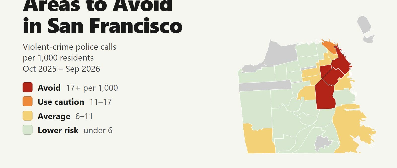
The areas to avoid in San Francisco are the Tenderloin, South of Market and the Mission, plus the Financial District around Union Square, which reaches the same tier for a different reason. Between October 2025 and September 2026, police were dispatched to 8.5 violent-crime calls per 1,000 residents citywide. These 4 neighborhoods ran at 17 or more, double the city rate. They are home to 17% of San Franciscans and produced 50% of the city’s violent-crime calls and 50% of its shootings and stabbings.
San Francisco keeps its worst blocks in the middle of the tourist district. The Tenderloin begins a few blocks west of Union Square, Moscone Center sits in South of Market, and the cable car turnaround at Powell and Market is on the Tenderloin’s edge. Visitors pass through these neighborhoods every day. The streets to skip are the Tenderloin blocks of Eddy, Ellis, Turk, Jones, Taylor and Leavenworth, Sixth Street south of Market, Market Street between Fifth and Eighth, and Mission Street around the 16th and 24th Street BART stations.
The rest of the city is calm. Russian Hill, Pacific Heights, the Marina, Noe Valley, the Sunset and the Richmond all run well below the city average. The crime visitors are most likely to meet anywhere in San Francisco is a car break-in. Citywide, violent-crime calls fell 4% and robbery calls fell 29% compared with the 12 months before.
San Francisco safety map
Red areas are the ones to avoid and orange areas call for caution. Grey areas are parks, the Presidio and small neighborhoods with too few residents for a reliable rate. Use the Downtown button to zoom in on Union Square, SoMa and the waterfront, and switch the map to Theft & robbery to see where pickpocketing and phone snatching happen. Tap or hover over a neighborhood for its numbers.
Violent-crime police calls per 1,000 residents
Theft & robbery calls per area
Tap or hover a neighborhood to see its numbers.
Table of Contents
- Areas to avoid in San Francisco
- Areas to be careful in
- Is downtown San Francisco safe?
- Car break-ins in San Francisco
- Is BART safe?
- Safest neighborhoods to stay in San Francisco
- San Francisco safety tips for visitors
- How this map was made
- FAQ
Areas to avoid in San Francisco
These are the 4 neighborhoods with at least double the city’s rate of violent-crime calls. In each one, the trouble is concentrated on a handful of streets.
| Neighborhood | Violent calls per 1,000 | vs. city avg | Robberies | Shootings & stabbings | Thefts + robberies | Car break-ins |
|---|---|---|---|---|---|---|
| South of Market | 39.3 | 4.6x | 127 | 66 | 847 | 104 |
| Tenderloin | 31.9 | 3.8x | 128 | 75 | 540 | 50 |
| Mission | 19.4 | 2.3x | 160 | 58 | 715 | 115 |
| Financial District/South Beach | 17.9 | 2.1x | 41 | 22 | 621 | 68 |
The Tenderloin
The Tenderloin is the center of San Francisco’s open-air drug market and recorded 1,151 violent-crime calls in 12 months, more than any other neighborhood. That works out to 31.9 per 1,000 residents, 3.8 times the city rate. The worst blocks run between Eddy, Ellis and Turk Streets and Jones, Taylor and Leavenworth Streets, a few minutes’ walk from Union Square.
Its edges hold places visitors go: City Hall, the Asian Art Museum and the Main Library at Civic Center, UN Plaza, the Orpheum and Golden Gate theaters, and the Powell Street cable car turnaround. Go to them directly along Market Street or by BART or Muni Metro, and don’t cut through the interior blocks to save a few minutes. Hotels listed as “Union Square” can be on the Tenderloin’s eastern blocks, west of Mason Street. Check the exact address before you book.
South of Market: Sixth Street and Mid-Market
South of Market, called SoMa, has the highest per-resident rate in the city, 39.3 per 1,000, and the most theft and robbery calls: 847 in 12 months. The violence clusters on Sixth Street between Market and Howard and on Market Street between Fifth and Eighth, the stretch called Mid-Market. Seventh and Eighth Streets near Mission are rough too.
The eastern half of SoMa is different. Moscone Center, Yerba Buena Gardens and the Westfield San Francisco Centre mall are busy and patrolled. Conference visitors can walk between Moscone and Union Square on Fourth Street or Third Street. Don’t walk west of Fifth Street at night.
The Mission
The Mission is the largest neighborhood on the list, with 57,824 residents and 1,122 violent-crime calls, 19.4 per 1,000. Most of them happen on Mission Street between 16th and 24th Streets, centered on the plazas outside the 16th Street and 24th Street BART stations. The blocks around the 16th Street station recorded more violent-crime calls than anywhere else in the Mission.
Visitors come for the taquerias, the Valencia Street restaurants and bars, the murals in Clarion Alley and Balmy Alley, Mission Dolores and Dolores Park. Valencia Street, one block west of Mission Street, is much calmer, and Dolores Park belongs to Castro/Upper Market, a neighborhood near the city average. Spend your time on Valencia and 24th Street, keep your phone out of sight at the BART plazas, and take a car home late at night.
Financial District, Union Square and South Beach
Financial District/South Beach reaches the avoid tier at 17.9 per 1,000, and that number overstates the risk. Only 25,732 people live there, while several hundred thousand office workers, shoppers and visitors pass through on a weekday, so a per-resident rate divides its calls by a small share of the people present. Its real problem is theft: 621 theft and robbery calls in 12 months, third in the city after SoMa and the Mission.
The neighborhood includes Union Square, the Ferry Building, the Embarcadero, the Salesforce Transit Center and Chinatown’s Dragon Gate on Grant Avenue. All of them are crowded by day. Watch your phone and bag around Union Square and on Powell Street, where snatch-and-run thefts happen, and on the Embarcadero after the office towers empty in the evening.
Areas to be careful in
One neighborhood falls between 11 and 17 violent-crime calls per 1,000 residents, and it is the one with Fisherman’s Wharf.
| Neighborhood | Violent calls per 1,000 | vs. city avg | Robberies | Shootings & stabbings | Thefts + robberies | Car break-ins |
|---|---|---|---|---|---|---|
| North Beach | 13.7 | 1.6x | 21 | 8 | 111 | 19 |
North Beach and Fisherman’s Wharf
North Beach (13.7 per 1,000) includes Fisherman’s Wharf, Pier 39, the Alcatraz ferry at Pier 33, Coit Tower and the Italian restaurants around Washington Square. Two things push its rate up: the Wharf’s crowds and the nightclubs on Broadway near Columbus Avenue, which close at 2 a.m. The Wharf is busy and safe by day. Leave nothing in a parked car, since the streets around Ghirardelli Square and the Wharf have had more car break-ins than almost anywhere else in the city in recent years.
Bayview Hunters Point
Bayview Hunters Point (10.6 per 1,000) sits just below the caution tier, but it recorded 38 shootings and stabbings, a total only the Tenderloin, SoMa and the Mission exceeded. It is mostly residential and industrial, in the city’s southeast corner, and nothing in it draws visitors. The T Third Street light rail runs through it on the way to Chase Center and Oracle Park from the south. Ride it from downtown instead.
Is downtown San Francisco safe?
Downtown San Francisco is safe for visitors who stay on the main streets and watch their belongings. Union Square, the Ferry Building, the Embarcadero, Chinatown, Nob Hill and the eastern half of SoMa are crowded and patrolled. The problem blocks are few and well known: the Tenderloin’s interior, Sixth Street and Mid-Market. Learn where they are and you can walk around them.
Violent-crime calls downtown follow the crowds. In the Tenderloin, SoMa and the Financial District, 42% of violent-crime calls came in between noon and 8 p.m., and the busiest hour was 4 p.m. Only 19% came between midnight and 6 a.m., but far fewer people are on the street then, so each person out late faces more risk than the totals suggest.
- Keep your phone in a front pocket around Union Square, on Powell Street and at the cable car turnaround. Snatch-and-run thefts happen in those spots.
- Walk on Market Street, not the side streets, between Union Square and Civic Center.
- Skip the Powell Street cable car line at the Market Street turnaround if the line is long. Board at a later stop on Powell, or ride the California Street line from the Financial District.
- After dark, take a taxi, Uber, Lyft or a Waymo robotaxi for any trip that crosses the Tenderloin or SoMa.
Car break-ins in San Francisco
Car break-ins are the crime most likely to hit a visitor in San Francisco, and rental cars are the favorite target. Break-ins have dropped sharply. A GrowSF analysis of SFPD data counted about 1,800 reported in the first half of 2026, around 10 a day, against roughly 30,000 in all of 2017, and the department reported a 43% drop in 2025 alone. Thieves still work the parking spots at viewpoints and landmarks, where they know visitors leave luggage, cameras and laptops.
The places with the most break-ins in recent years are the streets around Ghirardelli Square and Fisherman’s Wharf, the Painted Ladies at Alamo Square, the Palace of Fine Arts, the Twin Peaks summit lot, the crooked block of Lombard Street and the Lands End trailhead. Most break-ins are reported online and never produce a police dispatch, so the map’s theft layer undercounts them.
- Leave nothing visible in the car, including bags, charging cables, coats and empty shopping bags. A thief will break a window for a bag that turns out to be empty.
- Put luggage in the trunk before you arrive, not in the parking spot. Thieves watch for people loading trunks at viewpoints.
- At a hotel, use the garage or valet and take everything out of the car.
- Broken glass on the pavement marks a spot where break-ins happen. Park somewhere else.
- Skip the car downtown. Muni, BART, the cable cars and rideshares cover everything a visitor needs, and hotel parking costs more than most car rentals.
Is BART safe?
BART is safe and getting safer. The agency reports that crimes against riders per million trips fell 67% between December 2024 and June 2026, after it installed taller fare gates at all 50 stations. In 2025, violent crime on BART fell 31% and robberies fell 60%. BART is the fastest way from SFO to downtown, about 30 minutes to Powell Street.
Six of San Francisco’s eight BART stations are in avoid areas. Montgomery and Embarcadero are in the Financial District, where the rate reflects office crowds. The four to watch are Civic Center/UN Plaza and Powell Street in the Tenderloin and 16th Street Mission and 24th Street Mission. Inside the stations is calmer than the plazas outside them.
- Ride in the first car, where the operator is, late at night.
- Keep your phone in your pocket near the doors. Phone snatching just before the doors close is the most common BART theft.
- At Civic Center and 16th Street, leave the plaza promptly instead of waiting outside for a ride.
- Muni buses and light rail work the same way: sit near the driver late at night, and keep bags on your lap.
Safest neighborhoods to stay in San Francisco
These are the neighborhoods visitors stay in, with the same 12-month figures.
| Neighborhood | Violent calls per 1,000 | vs. city avg | Robberies | Shootings & stabbings | Thefts + robberies | Car break-ins |
|---|---|---|---|---|---|---|
| Russian Hill | 3.0 | 0.4x | 8 | 0 | 101 | 16 |
| Pacific Heights | 2.5 | 0.3x | 10 | 5 | 123 | 16 |
| Marina | 5.5 | 0.7x | 16 | 8 | 155 | 25 |
| Inner Sunset | 1.8 | 0.2x | 4 | 2 | 81 | 7 |
| Haight Ashbury | 5.8 | 0.7x | 4 | 4 | 90 | 8 |
| Hayes Valley | 6.0 | 0.7x | 20 | 10 | 171 | 22 |
| Castro/Upper Market | 7.9 | 0.9x | 21 | 7 | 163 | 23 |
| Mission Bay | 6.8 | 0.8x | 5 | 5 | 119 | 17 |
| Nob Hill | 9.5 | 1.1x | 25 | 9 | 380 | 45 |
| North Beach | 13.7 | 1.6x | 21 | 8 | 111 | 19 |
| Financial District/South Beach | 17.9 | 2.1x | 41 | 22 | 621 | 68 |
- Russian Hill (3.0 per 1,000) has one of the lowest rates in the city and is a walk from Fisherman’s Wharf, Lombard Street and the Hyde Street cable car.
- Pacific Heights (2.5) and the Marina (5.5) are quiet residential neighborhoods with small hotels and inns, close to the Palace of Fine Arts, Crissy Field and the Golden Gate Bridge.
- Nob Hill (9.5) is close to the city average because its lower slopes border the Tenderloin. The hotels at the summit, around Grace Cathedral, are a short cable car ride from Union Square.
- Hayes Valley (6.0) and the Castro (7.9) are central, walkable and full of restaurants. The Haight (5.8) and the Inner Sunset (1.8) put you next to Golden Gate Park.
- Union Square and Fisherman’s Wharf are the most convenient bases for a first visit. Their high rates come from crowds, and most of their crime is theft. At Union Square, pick a hotel east of Mason Street and north of Market.
San Francisco safety tips for visitors
- Check a hotel’s or rental’s exact address on the map before you book. A listing described as near Union Square or Civic Center can be in the Tenderloin.
- Expect to see people sleeping on sidewalks and using drugs in the open downtown. Most of them ignore passersby. Don’t engage, don’t stop to take photos and keep walking.
- Stay out of Golden Gate Park’s interior and the city’s other large parks after dark.
- Call 911 for emergencies. For a car break-in or theft with no suspect present, file a report online with SFPD or call the non-emergency line at 415-553-0123.
How this map was made
The counts come from DataSF’s Law Enforcement Dispatched Calls for Service, which lists every call that led to a police dispatch, from October 2025 through September 2026. San Francisco’s incident-report dataset, the usual source for neighborhood crime maps, currently publishes no locations, so this map counts dispatches. A violent-crime call is one whose final call type was homicide, robbery, purse snatching, shooting, stabbing, assault and battery, aggravated assault or a fight with weapons. Domestic-violence calls are left out, because they happen indoors and say little about the risk on the street. Calls that were canceled, duplicated or closed with no one found or no merit are left out too, as are calls located at a police station or a hospital emergency room, since those record where a report was taken, not where the crime happened.
The neighborhoods are the city’s 41 Analysis Neighborhoods. Population is the 2020 Census count, grouped into neighborhoods with DataSF’s tract table. Seven neighborhoods with fewer than 5,000 residents (Golden Gate Park, the Presidio, Lincoln Park, McLaren Park, Japantown, Seacliff and Treasure Island) are shown in grey and not ranked. The tiers are Avoid (17 or more violent-crime calls per 1,000 residents), Use caution (11 to 17), Average (6 to 11) and Lower risk (under 6). The theft layer counts grand theft, petty theft, car break-in and robbery calls, not rates.
Each neighborhood is large, and conditions change from block to block. Per-resident rates overstate risk where few people live and many visit, which applies to the Financial District, Union Square and Fisherman’s Wharf. We built the same map for the areas to avoid in Chicago, the areas to avoid in New York City, the areas to avoid in Los Angeles and the areas to avoid in Miami.
FAQ
Is San Francisco safe to visit?
Yes. San Francisco recorded 28 homicides in 2025, the fewest since 1954, and violent-crime calls fell 4% between October 2025 and September 2026 compared with the 12 months before. The trouble is concentrated on a few downtown streets in the Tenderloin, South of Market and the Mission. The crime visitors are most likely to meet is a car break-in.
What areas of San Francisco should you avoid?
The 4 neighborhoods with at least double the city's rate of violent-crime calls are the Tenderloin, South of Market, the Mission and Financial District/South Beach. The streets to skip are the Tenderloin blocks of Eddy, Ellis, Turk, Jones, Taylor and Leavenworth, Sixth Street south of Market, Market Street between Fifth and Eighth, and Mission Street around the 16th and 24th Street BART stations. The Financial District reaches the same tier because its daytime crowds far outnumber its residents.
Is the Tenderloin safe?
No. The Tenderloin recorded 1,151 violent-crime calls in 12 months, 31.9 per 1,000 residents and 3.8 times the city rate, and it is the center of the city's open-air drug market. Visit City Hall, the Asian Art Museum and the theaters on its edges directly along Market Street and don't walk through its interior blocks.
Is Union Square safe?
Union Square is safe by day and in the evening, and theft is the main risk. Financial District/South Beach, the neighborhood that includes it, recorded 621 theft and robbery calls in 12 months. The Tenderloin begins a few blocks west, so pick a hotel east of Mason Street and keep your phone in a front pocket on Powell Street.
Is Fisherman's Wharf safe?
Fisherman's Wharf is busy and safe by day. It is part of North Beach, which had 13.7 violent-crime calls per 1,000 residents, pushed up by the Wharf's crowds and the Broadway nightclubs. The bigger risk is a car break-in on the streets around the Wharf and Ghirardelli Square, so leave nothing in a parked car.
What is the safest neighborhood to stay in San Francisco?
Among the neighborhoods visitors stay in, Russian Hill (3.0 violent-crime calls per 1,000 residents), Pacific Heights (2.5) and the Marina (5.5) have the lowest rates. Russian Hill is a walk from Fisherman's Wharf and the Hyde Street cable car.
Is BART safe in San Francisco?
Yes. BART reports that crimes against riders per million trips fell 67% between December 2024 and June 2026, after new fare gates went in at every station. Be alert at the Civic Center, Powell Street, 16th Street Mission and 24th Street Mission stations, keep your phone in your pocket near the doors and ride in the first car late at night.
Is the Mission District safe?
The Mission's restaurants and bars on Valencia Street and 24th Street are safe to visit. The neighborhood reaches the avoid tier at 19.4 violent-crime calls per 1,000 residents because of Mission Street between 16th and 24th Streets, around the two BART station plazas. Spend your time on Valencia and take a car home late at night.