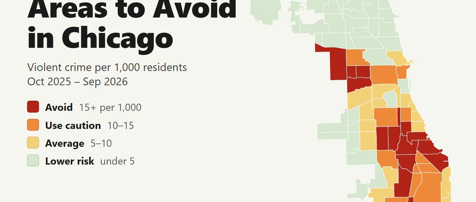
The areas to avoid in Chicago are on the West Side and the South Side, mostly away from the places visitors go. Between October 2025 and September 2026, 15 of the city’s 77 community areas recorded 15 or more violent crimes per 1,000 residents, about double the city average of 7.6. Those 15 areas are home to 16% of Chicago’s residents and account for 52% of its homicides and 52% of its shooting victims.
Areas to avoid: West Garfield Park, East Garfield Park, North Lawndale and Austin on the West Side. Englewood, West Englewood, Greater Grand Crossing, Washington Park, Woodlawn, South Shore, Chatham, South Chicago, Roseland, Riverdale and Fuller Park on the South Side.
The North Side lakefront and most of the hotel neighborhoods sit below the city average for violent crime. The Loop’s per-resident rate is higher, for a reason explained below. The risk a visitor is more likely to meet there is theft. The Near North Side, home to the Magnificent Mile and Navy Pier, recorded 4,422 thefts in the same 12 months, more than any other community area. Citywide, violent crime fell 12% and homicides fell 11% compared with the 12 months before.
Chicago safety map
Red areas are the ones to avoid and orange areas call for caution. Switch the map to Theft & robbery to see where pickpocketing and phone snatching happen, which is mostly where the crowds are. Tap or hover over a neighborhood for its numbers.
Violent crimes per 1,000 residents
Thefts & robberies per area
Tap or hover a neighborhood to see its numbers.
Table of Contents
- Areas to avoid in Chicago
- Areas to be careful in
- Is downtown Chicago safe?
- Safest neighborhoods to stay in Chicago
- Is the South Side of Chicago dangerous?
- Is the CTA safe?
- Chicago safety tips for visitors
- How this map was made
- FAQ
Areas to avoid in Chicago
These are the 15 community areas with at least double the city’s violent crime rate. Each one is a large neighborhood with thousands of residents, and its violence is concentrated on particular blocks. There is no visitor reason to walk through most of them, especially at night.
| Neighborhood | Violent crimes per 1,000 | vs. city avg | Homicides | Shooting victims | Thefts + robberies |
|---|---|---|---|---|---|
| Fuller Park | 41.4 | 5.5x | 8 | 18 | 137 |
| West Garfield Park | 29.3 | 3.9x | 27 | 93 | 500 |
| Greater Grand Crossing | 27.8 | 3.7x | 24 | 86 | 1,025 |
| Englewood | 26.5 | 3.5x | 21 | 84 | 650 |
| Washington Park | 24.4 | 3.2x | 5 | 37 | 345 |
| Riverdale | 21.8 | 2.9x | 4 | 21 | 146 |
| East Garfield Park | 20.9 | 2.8x | 12 | 53 | 596 |
| Chatham | 20.6 | 2.7x | 9 | 54 | 1,079 |
| North Lawndale | 20.6 | 2.7x | 14 | 95 | 929 |
| South Shore | 19.3 | 2.6x | 11 | 66 | 1,437 |
| West Englewood | 17.9 | 2.4x | 16 | 53 | 726 |
| South Chicago | 16.8 | 2.2x | 8 | 40 | 563 |
| Woodlawn | 16.3 | 2.2x | 10 | 37 | 769 |
| Roseland | 15.2 | 2.0x | 15 | 68 | 879 |
| Austin | 15.0 | 2.0x | 34 | 143 | 1,938 |
West Side: Garfield Park, North Lawndale and Austin
West Garfield Park has the highest violent crime rate of any sizable community area in Chicago: 29.3 per 1,000 residents, 3.9 times the city average. East Garfield Park, North Lawndale and Austin complete the West Side cluster. Austin recorded 143 shooting victims, the most of any community area.
Three places bring visitors to this part of the city:
- Garfield Park Conservatory. It is in East Garfield Park. Take the Green Line to Conservatory-Central Park Drive, which stops next to the entrance, and go during the day.
- Oak Park. The Green Line to Oak Park and the Frank Lloyd Wright Home and Studio runs through both Garfield Parks and Austin. Stay on the train.
- United Center. The arena is in the Near West Side, less than a mile east of East Garfield Park. Use the official lots or a rideshare, and leave toward the Loop after games and concerts.
South Side: Englewood, Greater Grand Crossing and Washington Park
The South Side cluster is larger. Greater Grand Crossing (27.8 per 1,000) and Englewood (26.5) have the highest rates. South Shore recorded 1,034 violent crimes, the second-highest count in the city after Austin.
Visitors meet this part of the city in three places:
- Obama Presidential Center. It opened in June 2026 in Jackson Park, on the east edge of Woodlawn. CTA buses #6, #10, #15 and #28 stop at the campus, Metra’s 59th Street and 63rd Street stations are close, and there is a paid garage off Stony Island Avenue. Stay on the campus and the park side of Stony Island.
- DuSable Black History Museum. It sits on the east side of Washington Park, the park. Drive or take a rideshare in daylight. Don’t walk west of the park.
- South Shore Cultural Center. A lakefront landmark with a beach. Visit during the day.
Fuller Park and Rate Field
Fuller Park has the highest rate on the list, 41.4 per 1,000, but it is a narrow strip of rail yards and homes along the Dan Ryan Expressway with 2,344 residents. Its 97 violent crimes produce an extreme rate. It starts a few blocks south of Rate Field, the White Sox ballpark. On game days, arrive and leave through the Sox-35th Red Line station or the stadium lots.
Areas to be careful in
Another 12 areas have between 10 and 15 violent crimes per 1,000 residents. Most are on the Far South Side: Auburn Gresham, West Pullman, Pullman, Avalon Park and South Deering. Visitors do go to three of them.
| Neighborhood | Violent crimes per 1,000 | vs. city avg | Homicides | Shooting victims | Thefts + robberies |
|---|---|---|---|---|---|
| Avalon Park | 14.4 | 1.9x | 2 | 11 | 215 |
| West Pullman | 14.2 | 1.9x | 9 | 38 | 497 |
| Auburn Gresham | 13.8 | 1.8x | 24 | 64 | 1,056 |
| Pullman | 13.5 | 1.8x | 1 | 8 | 271 |
| South Deering | 12.6 | 1.7x | 5 | 16 | 375 |
| Burnside | 11.7 | 1.6x | 0 | 3 | 43 |
| Grand Boulevard | 11.5 | 1.5x | 2 | 35 | 695 |
| New City | 11.3 | 1.5x | 12 | 65 | 701 |
| Loop | 11.2 | 1.5x | 6 | 20 | 3,277 |
| Calumet Heights | 10.9 | 1.4x | 4 | 11 | 237 |
| Humboldt Park | 10.5 | 1.4x | 9 | 70 | 1,031 |
| Near West Side | 10.5 | 1.4x | 10 | 68 | 3,007 |
The Loop
The Loop’s rate of 11.2 per 1,000 overstates the risk. Only 42,550 people live there, and many times that number work, shop and visit every day, so a per-resident rate divides downtown’s crimes by a small share of the people actually present. The Loop recorded 6 homicides in 12 months. Its real problem is theft: 3,092 thefts, the second-highest count in the city after the Near North Side.
Near West Side: West Loop and the United Center
The Near West Side (10.5 per 1,000) covers the West Loop restaurant district, Greektown, the University of Illinois Chicago, the United Center and the Illinois Medical District. Almost half of its violent crime happens west of Ashland Avenue, on the United Center side. Randolph Street and Fulton Market, where most visitors go, are east of Ashland.
Humboldt Park
Humboldt Park (10.5 per 1,000) borders Wicker Park and Logan Square, two neighborhoods popular with visitors that are both well below the city average. If you visit the park itself, go during the day.
Is downtown Chicago safe?
Downtown Chicago is safe for visitors who watch their phones and avoid walking around after midnight. The Loop and the Near North Side together recorded 1,096 violent crimes in 12 months, and 31% of them happened between midnight and 4 a.m. Theft follows the crowds instead: 46% of downtown thefts and robberies happened between noon and 6 p.m.
- Keep your phone in your pocket at the curb, at train doors and at outdoor tables. Snatch-and-run thefts happen in those spots.
- Carry bags zipped and in front of you on State Street, Michigan Avenue and the Red Line.
- After dark, stay on main streets such as Michigan Avenue, State Street and the Riverwalk while it is busy. Don’t use Lower Wacker Drive as a walking route.
- After midnight, take a taxi or rideshare instead of walking or riding the train.
Safest neighborhoods to stay in Chicago
These are the neighborhoods visitors stay in, with the same 12-month figures. Community area names come first. The neighborhood names visitors know are listed below.
| Neighborhood | Violent crimes per 1,000 | vs. city avg | Homicides | Shooting victims | Thefts + robberies |
|---|---|---|---|---|---|
| Lincoln Park | 2.4 | 0.3x | 1 | 4 | 1,614 |
| Lake View | 2.9 | 0.4x | 1 | 8 | 2,416 |
| Logan Square | 3.1 | 0.4x | 1 | 5 | 1,616 |
| West Town | 3.9 | 0.5x | 5 | 16 | 2,199 |
| Near South Side | 4.4 | 0.6x | 0 | 4 | 512 |
| Near North Side | 5.8 | 0.8x | 5 | 24 | 4,659 |
| Hyde Park | 5.3 | 0.7x | 2 | 16 | 782 |
| Near West Side | 10.5 | 1.4x | 10 | 68 | 3,007 |
| Loop | 11.2 | 1.5x | 6 | 20 | 3,277 |
- Lincoln Park (2.4 per 1,000) has the lowest rate of any neighborhood next to downtown. It has the zoo, the lakefront parks and DePaul University, and it is a short ride from downtown on the Red and Brown Lines.
- Lake View (2.9) includes Wrigleyville and Boystown. It is the best base for a Cubs game.
- Logan Square (3.1) and Wicker Park (part of West Town, 3.9) are the bar and restaurant neighborhoods on the Blue Line.
- South Loop and Museum Campus (Near South Side, 4.4) are walkable to the Field Museum, Shedd Aquarium and Soldier Field.
- River North, Streeterville, the Gold Coast and the Magnificent Mile (Near North Side, 5.8) are the most convenient base for a first visit. Violent crime is below the city average. Theft is the risk, so watch your phone.
- West Loop (Near West Side) is the restaurant district. Stay east of Ashland Avenue.
Is the South Side of Chicago dangerous?
The South Side covers more than half of Chicago’s land area and is not one place. Eleven of the 15 areas to avoid are on the South Side, but so are the Museum Campus, Chinatown, Bridgeport, Hyde Park, the University of Chicago and the Museum of Science and Industry. Bridgeport’s violent crime rate (3.0 per 1,000) is close to Lake View’s, and Hyde Park’s (5.3) is below the city average. Use the map to check a specific address. Calling a place South Side tells you very little.
Is the CTA safe?
In 12 months, police recorded 2,367 crimes on CTA trains, platforms and in stations, and 435 of them were violent. 20% happened in the Loop, where most lines meet.
- Ride in the first car, where the operator is. Every rail car also has an emergency intercom to the operator.
- The Red and Blue Lines run 24 hours. Late at night, pick a car with other riders in it, or take a rideshare.
- The Blue Line runs to O’Hare and the Orange Line runs to Midway. Both are the cheapest way to and from the airports.
- Don’t hold your phone near the doors as they open. That is when it gets grabbed.
Chicago safety tips for visitors
- Check a rental’s exact address on the map before you book. A listing described as near the United Center can be in East Garfield Park.
- Leave nothing visible in a parked car.
- Use the Lakefront Trail and the beaches while they are busy, and leave at dusk on the quieter stretches.
- Call 911 for emergencies and 311 for non-emergency city services.
How this map was made
Crime counts come from the City of Chicago’s Crimes dataset, which lists every incident reported to the Chicago Police Department, for October 2025 through September 2026. Violent crime means the FBI’s violent index offenses: homicide, criminal sexual assault, robbery, aggravated assault and aggravated battery. Shooting victims come from the city’s Violence Reduction victims dataset and include fatal and non-fatal shootings. Population is the American Community Survey five-year estimate published by the Chicago Metropolitan Agency for Planning in its 2026 Community Data Snapshots.
The tiers are Avoid (15 or more violent crimes per 1,000 residents), Use caution (10 to 15), Average (5 to 10) and Lower risk (under 5). The theft layer counts thefts and robberies, not rates, because a per-resident rate means little where most of the people present live elsewhere. 173 violent crimes recorded without a community area are left out of the area totals.
Chicago’s 77 community areas are the city’s official statistical neighborhoods. Each one is large, and conditions change from block to block. Per-resident rates overstate risk where few people live and many visit, which applies to the Loop and Fuller Park.
FAQ
Is Chicago safe to visit?
Yes. The places visitors spend their time, including downtown, the lakefront, Lincoln Park, Lake View and the Museum Campus, have violent crime rates near or below the city average. Chicago's violence is concentrated in 15 West Side and South Side community areas that hold 16% of residents and 52% of homicides. Citywide, violent crime fell 12% in the 12 months to September 2026.
What areas of Chicago should you avoid?
West Garfield Park, East Garfield Park, North Lawndale and Austin on the West Side, and Englewood, West Englewood, Greater Grand Crossing, Washington Park, Woodlawn, South Shore, Chatham, South Chicago, Roseland, Riverdale and Fuller Park on the South Side. Each recorded 15 or more violent crimes per 1,000 residents between October 2025 and September 2026, about double the city average of 7.6.
Is the South Side of Chicago dangerous?
Parts of it are. Eleven of the 15 areas to avoid are on the South Side, but so are the Museum Campus, Chinatown, Bridgeport, Hyde Park and the Museum of Science and Industry. Bridgeport has 3.0 violent crimes per 1,000 residents and Hyde Park has 5.3, both below the city average of 7.6.
Is downtown Chicago safe at night?
Downtown is busy and safe on the main streets in the evening. Violent crime in the Loop and the Near North Side peaks after midnight: 31% of it happened between midnight and 4 a.m. After midnight, take a taxi or rideshare instead of walking or riding the train.
What is the safest neighborhood to stay in Chicago?
Lincoln Park has the lowest violent crime rate of the neighborhoods next to downtown, at 2.4 per 1,000 residents. Lake View (2.9) and the South Loop (4.4) are also well below the city average. For a first visit, River North, Streeterville and the Gold Coast (5.8) are the most convenient, with theft as the main risk.
Is the CTA safe for tourists?
Yes, with ordinary care. Police recorded 435 violent crimes on CTA trains, platforms and in stations in 12 months. Ride in the first car near the operator, keep your phone away from the doors and take a rideshare late at night.
Is the Loop in Chicago safe?
The Loop's per-resident rate of 11.2 looks high because only 42,550 people live there while far more work and visit every day. It recorded 6 homicides in 12 months. Theft is the main risk: 3,092 thefts, the second-highest count in the city.