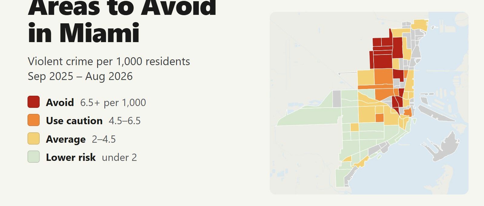
The areas to avoid in Miami are Overtown, on the west side of downtown, and Liberty City and the western half of Little Haiti, a few miles north. Between September 2025 and August 2026, 12 of the city’s neighborhoods recorded 6.5 or more violent crimes per 1,000 residents, about double the city average of 3.3. Those 12 neighborhoods are home to 10% of Miami’s residents and account for 33% of its violent crime, 7 of its 15 homicides and 45% of its ShotSpotter gunfire alerts.
Areas to avoid: Southeast Overtown, Northeast Overtown and Culmer in Overtown. Liberty Square, Northwestern Estates, Orchard Villa, King Heights, Hadley Park and Flora Park in Liberty City. Edison in Little Haiti. Lummus Park on the Miami River and Old San Juan on the north side of Wynwood.
Brickell, Brickell Key, Coconut Grove, Coral Way and Flagami have violent crime rates well below the city average. Downtown and Wynwood rate higher per resident because far more people work and visit there than live there, and the risk a visitor is more likely to meet in them is theft. East Little Havana recorded 630 thefts and robberies in 12 months, more than any other neighborhood. Citywide, Miami Police reported 12% fewer violent crimes in the 11 months to July 2026 than a year earlier, and 16 homicides in the 12 months to August, down from 26. Miami Beach is a separate city with its own police department and is covered in the county section below.
Miami safety map
Red areas are the ones to avoid and orange areas call for caution. Grey areas have fewer than 1,500 residents: parks, islands, PortMiami and the business blocks of downtown and Wynwood. Use the North, Central and South buttons to zoom in, and switch the map to Theft & robbery to see where pickpocketing, shoplifting and car break-ins happen. Tap or hover over a neighborhood for its numbers.
Violent crimes per 1,000 residents
Thefts & robberies per area
Tap or hover a neighborhood to see its numbers.
Table of Contents
- Areas to avoid in Miami
- Areas to be careful in
- Is downtown Miami safe?
- Is Wynwood safe?
- Is Little Havana safe?
- Safest neighborhoods to stay in Miami
- Miami Beach and the rest of Miami-Dade County
- Miami safety tips for visitors
- How this map was made
- FAQ
Areas to avoid in Miami
These are the 12 neighborhoods with at least double the city’s violent crime rate. They are small neighborhoods of about 2,000 to 8,000 residents each, and the violence in them is concentrated on particular blocks. There is no visitor reason to walk through most of them, especially at night.
| Neighborhood | Area | Violent crimes per 1,000 | vs. city avg | Homicides | Aggravated assaults | Thefts + robberies |
|---|---|---|---|---|---|---|
| Southeast OvertownOvertown | Overtown | 21.6 | 6.6x | 1 | 32 | 366 |
| Liberty SquareModel City | Model City | 20.7 | 6.3x | 0 | 50 | 88 |
| Northwestern EstatesModel City | Model City | 16.0 | 4.9x | 0 | 39 | 165 |
| Northeast OvertownOvertown | Overtown | 14.7 | 4.5x | 0 | 23 | 68 |
| CulmerOvertown | Overtown | 11.3 | 3.5x | 0 | 28 | 57 |
| Orchard VillaModel City | Model City | 11.3 | 3.5x | 0 | 29 | 78 |
| King HeightsModel City | Model City | 10.1 | 3.1x | 0 | 28 | 146 |
| EdisonLittle Haiti | Little Haiti | 8.1 | 2.5x | 2 | 51 | 124 |
| Hadley ParkModel City | Model City | 8.1 | 2.5x | 4 | 46 | 157 |
| Lummus ParkDowntown | Downtown | 7.8 | 2.4x | 0 | 13 | 35 |
| Old San JuanWynwood | Wynwood | 7.6 | 2.3x | 0 | 18 | 194 |
| Flora ParkModel City | Model City | 7.5 | 2.3x | 0 | 18 | 34 |
Overtown: Southeast Overtown, Northeast Overtown and Culmer
Southeast Overtown has the highest violent crime rate in Miami: 21.6 per 1,000 residents, 6.6 times the city average. It is the historic center of Overtown, the neighborhood around the Lyric Theater, and it begins directly west of MiamiCentral, the downtown station for Brightline trains from Orlando, West Palm Beach and Fort Lauderdale. It also recorded 366 thefts and robberies, among the most in the city. Northeast Overtown (14.7) and Culmer (11.3) complete the cluster, with Town Park one tier lower.
Visitors meet Overtown in three places:
- MiamiCentral. The free Metromover and the Metrorail’s Government Center station are next to the station. Head east into downtown, and don’t walk west into Overtown at night.
- Lyric Theater. The restored 1913 theater on NW 2nd Avenue hosts concerts and plays. Arrive and leave by car or rideshare.
- Metrorail from the airport. The Orange Line from Miami International Airport to downtown runs on an elevated track through Allapattah, Civic Center, Culmer and Overtown. Stay on the train until Government Center or Brickell.
Liberty City: Liberty Square, Northwestern Estates and Hadley Park
The City of Miami’s police call this part of the city Model City. Most Miamians call it Liberty City. It holds six of the 12 avoid neighborhoods and recorded 283 violent crimes in 12 months, 11.4 per 1,000 residents. Liberty Square, the public housing community at the center of Liberty City, has the second-highest rate in Miami at 20.7. Hadley Park recorded 4 homicides, the most of any neighborhood, and 46 aggravated assaults.
Nothing in Liberty City draws visitors. The neighborhood continues north and west past the city limit into Gladeview and Brownsville, which are unincorporated and policed by the Miami-Dade Sheriff’s Office. The Sheriff’s Office publishes no neighborhood figures, so the map stops at the city line.
Little Haiti: Edison
Edison (8.1 per 1,000) is the western half of Little Haiti. It registered 58 ShotSpotter gunfire alerts, more than any other neighborhood. The Little Haiti Cultural Complex and the Caribbean shops and restaurants on NE 2nd Avenue are in Lemon City/Little Haiti, east of Edison, an average-tier neighborhood at 4.0. Visit them during the day.
Lummus Park and Old San Juan
Lummus Park (7.8) is a small historic district on the north bank of the Miami River, just west of downtown, with 1,932 residents. Old San Juan (7.6) is the residential north side of Wynwood, a few blocks from the Wynwood Walls. It is covered in the Wynwood section below.
Areas to be careful in
Another 7 neighborhoods have between 4.5 and 6.5 violent crimes per 1,000 residents. Visitors go to most of them.
| Neighborhood | Area | Violent crimes per 1,000 | vs. city avg | Homicides | Aggravated assaults | Thefts + robberies |
|---|---|---|---|---|---|---|
| Allapattah Industrial DistrictAllapattah | Allapattah | 6.3 | 1.9x | 0 | 10 | 96 |
| Town ParkOvertown | Overtown | 6.2 | 1.9x | 0 | 8 | 19 |
| Central Business DistrictDowntown | Downtown | 6.1 | 1.9x | 0 | 23 | 493 |
| Civic CenterAllapattah | Allapattah | 6.1 | 1.9x | 0 | 25 | 283 |
| MidtownWynwood | Wynwood | 5.1 | 1.6x | 0 | 10 | 516 |
| Latin QuarterLittle Havana | Little Havana | 4.8 | 1.5x | 0 | 33 | 110 |
| Santa ClaraAllapattah | Allapattah | 4.8 | 1.5x | 0 | 45 | 291 |
- Central Business District (6.1). Downtown’s office core around Flagler Street. See the downtown section below.
- Midtown (5.1). The shopping and apartment district between Wynwood and the Design District recorded 516 thefts and robberies, the second-highest count in the city.
- Allapattah Industrial District (6.3) and Santa Clara (4.8). The Rubell Museum and Superblue face each other across NW 23rd Street, on the line between the two. Drive or take a rideshare, and visit during the day.
- Civic Center (6.1). Miami’s Health District, with Jackson Memorial Hospital and the University of Miami medical campus. Use the hospital garages.
- Latin Quarter (4.8). The heart of Little Havana along Calle Ocho. See the Little Havana section below.
Is downtown Miami safe?
Downtown Miami is safe for visitors who watch their belongings and take a rideshare late at night. Downtown and Brickell together recorded 205 violent crimes in 12 months and 1,898 thefts and robberies, about nine thefts for every violent crime. 35% of the thefts and robberies happened between noon and 6 p.m., peaking around 4 p.m.
The Central Business District, around Flagler Street and the courthouses, rates caution at 6.1 per 1,000 and recorded 493 thefts and robberies. Bayside Marketplace, Bayfront Park, the Kaseya Center and the Pérez Art Museum sit in waterfront blocks with almost no residents, which is why they are grey on the map.
- The Metromover is free and loops through downtown, Brickell and the Omni area until midnight. It is the easiest way between hotels, Bayside and the Kaseya Center.
- After a Heat game or a concert, walk back along Biscayne Boulevard with the crowd, or take the Metromover.
- PortMiami is a short taxi or rideshare from the downtown hotels.
- Keep your phone in your pocket at outdoor tables and bus stops on Flagler Street and Biscayne Boulevard.
Is Wynwood safe?
Wynwood is safe to visit for the murals, galleries, breweries and restaurants, during the day and in the evening. The Wynwood police neighborhood has a rate of 10.8 per 1,000, the third-highest in the city, but only 7,058 people live there and many times that number visit. The Wynwood Industrial District and the Fashion District, which holds the Wynwood Walls, have fewer than 1,000 residents between them, so they have no rate on the map. The Wynwood Industrial District recorded 28 violent crimes and 186 thefts and robberies in 12 months, and the Fashion District 6 and 36.
Old San Juan, the residential blocks on Wynwood’s north side, rates avoid at 7.6. Midtown, on Wynwood’s east side, rates caution.
- Park in a staffed garage or lot, not on a dark side street, and leave nothing visible in the car.
- Stay on NW 2nd Avenue and the blocks around the Wynwood Walls at night. They are busy until the bars close.
- Book a rideshare to leave, and wait for it inside a bar or restaurant.
Is Little Havana safe?
Little Havana is safe to visit. The Little Havana police neighborhood has a rate of 3.1 per 1,000, close to the city average. Calle Ocho, with Domino Park, the Tower Theater and the music bars around Ball & Chain, runs through East Little Havana (2.7) and along the south edge of Latin Quarter (4.8). Most of what happens to visitors there is theft: East Little Havana recorded more thefts and robberies than any other neighborhood in Miami.
- The free City of Miami trolley connects Little Havana with Brickell.
- loanDepot park, the Marlins’ stadium, is in the Orange Bowl neighborhood (4.1). Use the stadium garages and leave with the crowd.
- Keep your phone and bag close on the busy stretch of Calle Ocho between SW 12th and SW 17th Avenues.
Safest neighborhoods to stay in Miami
These are the neighborhoods visitors stay in, with the same 12-month figures.
| Neighborhood | Area | Violent crimes per 1,000 | vs. city avg | Homicides | Aggravated assaults | Thefts + robberies |
|---|---|---|---|---|---|---|
| Brickell KeyBrickell | Brickell | 0.4 | 0.1x | 0 | 1 | 5 |
| Brickell Business DistrictBrickell | Brickell | 0.9 | 0.3x | 0 | 8 | 79 |
| Brickell VillageBrickell | Brickell | 3.3 | 1.0x | 0 | 23 | 349 |
| North GroveCoconut Grove | Coconut Grove | 0.6 | 0.2x | 0 | 0 | 10 |
| Grove CenterCoconut Grove | Coconut Grove | 2.9 | 0.9x | 0 | 5 | 70 |
| EdgewaterEdgewater | Edgewater | 2.0 | 0.6x | 0 | 24 | 297 |
| Omni / Arsht CenterDowntown | Downtown | 3.8 | 1.2x | 0 | 4 | 64 |
| Central Business DistrictDowntown | Downtown | 6.1 | 1.9x | 0 | 23 | 493 |
- Brickell Key (0.4 per 1,000) is a small island of condos and hotels joined to Brickell by one bridge. It has the lowest rate of any neighborhood near downtown.
- Brickell (0.9 in the business district) is the financial district, with many of the city’s high-rise hotels, Brickell City Centre and the free Metromover. Brickell Village (3.3), around Mary Brickell Village and the restaurants on S Miami Avenue, recorded 349 thefts and robberies, so watch your phone there.
- Coconut Grove (0.6 in North Grove, 2.9 in Grove Center) has the lowest rates of the neighborhoods visitors stay in after Brickell Key, with CocoWalk, the Dinner Key marinas and Vizcaya nearby. The Metrorail’s Coconut Grove station on US-1 connects it to downtown.
- Edgewater (2.0) is a strip of bayfront condos north of downtown, a short ride from Wynwood and the Design District.
- Downtown (Omni / Arsht Center 3.8, Central Business District 6.1) is the closest base to Bayside, the Kaseya Center and PortMiami, which makes it convenient before a cruise. Most of the crime there is theft.
Miami Beach and the rest of Miami-Dade County
The City of Miami is home to about 440,000 of Miami-Dade County’s 2.7 million residents. The rest of the county is policed by the Sheriff’s Office and dozens of city police departments, and none of them publish neighborhood crime data. This table compares whole cities using the figures each agency reports to the FBI. The county rate across these agencies was 3.1 per 1,000 in 2025.
| City / area | Population | Violent crimes | Per 1,000 | Year |
|---|---|---|---|---|
| Florida City | 13,194 | 206 | 15.6 | 2025 |
| Opa-locka | 16,539 | 211 | 12.8 | 2025 |
| Miami Beach | 79,031 | 849 | 10.7 | 2022 |
| North Miami | 58,502 | 438 | 7.5 | 2022 |
| North Miami Beach | 46,232 | 235 | 5.1 | 2025 |
| Homestead | 87,171 | 385 | 4.4 | 2025 |
| Miami Gardens | 117,389 | 421 | 3.6 | 2025 |
| City of Miami | 498,792 | 1,787 | 3.6 | 2025 |
| Unincorporated Miami-Dade (Sheriff's Office) | 1,200,003 | 4,026 | 3.4 | 2025 |
| South Miami | 13,539 | 43 | 3.2 | 2025 |
| Sweetwater | 21,875 | 46 | 2.1 | 2025 |
| Hialeah | 238,769 | 412 | 1.7 | 2025 |
| Aventura | 40,657 | 48 | 1.2 | 2025 |
| Miami Shores | 11,974 | 14 | 1.2 | 2025 |
| Palmetto Bay | 25,682 | 29 | 1.1 | 2025 |
| Sunny Isles Beach | 23,068 | 21 | 0.9 | 2025 |
| Cutler Bay | 45,992 | 42 | 0.9 | 2025 |
| Doral | 85,601 | 68 | 0.8 | 2025 |
| Coral Gables | 50,539 | 31 | 0.6 | 2025 |
| Hialeah Gardens | 23,422 | 12 | 0.5 | 2025 |
| Miami Lakes | 33,991 | 14 | 0.4 | 2025 |
Murder, rape, robbery and aggravated assault reported to the FBI by each agency, per 1,000 residents of the population the agency reports. Source: FBI Crime Data Explorer. Latest complete year where it is not 2025: Miami Beach (2022), North Miami (2022). Agencies that report no complete year are left out.
- Florida City has the highest rate in the county. It is the last town on US-1 before the Florida Keys and the nearest town to the main entrance of Everglades National Park, so many visitors stop there for gas and food. Stop on US-1 and Krome Avenue during the day.
- Opa-locka, northwest of Miami, is known for its Moorish Revival city hall. It has nothing else that draws visitors.
- Miami Beach has about 80,000 residents and millions of visitors a year, which raises its per-resident rate the same way crowds raise downtown’s. Its most recent complete year in the FBI data is 2022. Most of the trouble is on South Beach around Ocean Drive and Collins Avenue late at night, and during spring break in March, when the city adds police and restricts parking.
- Miami Gardens is home to Hard Rock Stadium, where the Dolphins play. Its rate is the same as the City of Miami’s. Drive or take a rideshare to games and concerts.
- Coral Gables, Doral, Aventura and Sunny Isles Beach are among the cities with the lowest rates in the county, all near 1 per 1,000 or below.
The Sheriff’s Office row covers 1.2 million people in unincorporated Miami-Dade, from Gladeview and Brownsville next to Liberty City to the suburbs of Kendall. One number for all of them hides large differences.
Miami safety tips for visitors
- Check a rental’s exact address on the map before you book. A listing described as near Wynwood or the Design District can be in Old San Juan, Edison or Liberty City.
- Leave nothing visible in a parked car, including in hotel garages. Thefts from cars made up 24% of all thefts in the city, 2,087 in 12 months.
- After midnight, take a taxi or rideshare instead of walking, even short distances.
- Don’t leave bags unattended on the beach or at Bayfront Park.
- Call 911 for emergencies and 311 for non-emergency county services.
How this map was made
Crime counts come from the City of Miami Police Department’s public crime incident records, which list every offense reported to the department, for September 2025 through August 2026. Violent crime means murder and manslaughter, rape and other forcible sex offenses, robbery and aggravated assault. ShotSpotter alerts come from the department’s calls-for-service records. Population is the 2020 Census count by census block, the most recent full count. The year-over-year change and the county table use each agency’s reports to the FBI’s Crime Data Explorer.
The neighborhoods are the City of Miami’s official boundaries for its 102 neighborhoods. The tiers are Avoid (6.5 or more violent crimes per 1,000 residents), Use caution (4.5 to 6.5), Average (2 to 4.5) and Lower risk (under 2). Neighborhoods with fewer than 1,500 residents are grey and not ranked. The theft layer counts thefts and robberies, not rates, because a per-resident rate means little where most of the people present live elsewhere.
Conditions change from block to block. Per-resident rates overstate risk where few people live and many visit, which applies to downtown, Wynwood and Midtown. The City of Miami has grown since 2020, most of all in Brickell, Edgewater and downtown, so rates there are lower than shown. We built the same map for the areas to avoid in Chicago, the areas to avoid in New York City, the areas to avoid in San Francisco and the areas to avoid in Los Angeles.
FAQ
Is Miami safe to visit?
Yes. The City of Miami's violent crime rate was 3.3 per 1,000 residents between September 2025 and August 2026, and violent crime fell 12% compared with a year earlier. The neighborhoods with the most violence are Overtown, Liberty City and western Little Haiti, away from the places most visitors go. In downtown, Brickell, Wynwood and Little Havana, the most common crime is theft.
What areas of Miami should you avoid?
The 12 neighborhoods with at least double the city's violent crime rate are Southeast Overtown, Northeast Overtown and Culmer in Overtown; Liberty Square, Northwestern Estates, Orchard Villa, King Heights, Hadley Park and Flora Park in Liberty City; Edison in Little Haiti; Lummus Park on the Miami River; and Old San Juan on the north side of Wynwood.
Is Overtown safe?
Overtown has the highest violent crime rate in Miami. Southeast Overtown, its historic center, recorded 21.6 violent crimes per 1,000 residents, 6.6 times the city average. Visitors pass it at the MiamiCentral Brightline station and on the Metrorail from the airport. Head east into downtown from the station, and go to the Lyric Theater by car or rideshare.
Is Liberty City dangerous?
Yes. Liberty City, which the City of Miami's police call Model City, holds six of the 12 areas to avoid and recorded 11.4 violent crimes per 1,000 residents, more than three times the city average. Liberty Square, at its center, has the second-highest rate in Miami. Nothing there draws visitors.
Is Wynwood safe at night?
Wynwood's main streets around the Wynwood Walls and NW 2nd Avenue are busy until the bars close and are safe in the evening. Park in a staffed garage or lot, leave nothing visible in the car and take a rideshare to leave. Old San Juan, the residential blocks on Wynwood's north side, rates avoid at 7.6 per 1,000.
Is Little Havana safe?
Little Havana is safe to visit. Its rate of 3.1 violent crimes per 1,000 residents is close to the city average. Theft is the main risk: East Little Havana recorded 630 thefts and robberies in 12 months, the most of any neighborhood, so keep your phone and bag close on Calle Ocho.
What is the safest area to stay in Miami?
Within the City of Miami, Brickell Key (0.4 violent crimes per 1,000 residents), the Brickell business district (0.9) and Coconut Grove (0.6 in North Grove) have the lowest rates of the neighborhoods visitors stay in. Outside the city, Coral Gables, Aventura and Sunny Isles Beach have some of the lowest rates in the county.
Is Miami Beach safe?
Miami Beach is safe for visitors who watch their drinks, phones and bags. Its per-resident violent crime rate is high because about 80,000 people live there and millions visit every year. Most of the trouble is on South Beach around Ocean Drive and Collins Avenue late at night and during spring break in March.