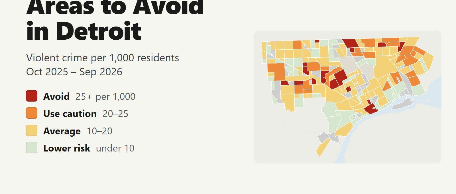
The areas to avoid in Detroit are residential neighborhoods on the west side, along Dexter Avenue, Grand River Avenue and Plymouth Road, and on the northeast side between 6 Mile and 8 Mile Roads. Between October 2025 and September 2026, 17 neighborhoods recorded 25 or more violent crimes per 1,000 residents, against a city average of 14.7. Those 17 neighborhoods are home to 7% of Detroit’s residents and account for 14% of its violent crime, 25 of its 139 homicides and 57 of its 438 non-fatal shootings.
Areas to avoid: Dexter-Linwood, LaSalle Gardens and Nardin Park on the near west side. Pride Area Community, Weatherby, Plymouth-I96, Littlefield Community, Davison-Schoolcraft, Hubbell-Lyndon, Belmont and Pembroke further west and northwest. Nolan, Nortown, Hawthorne Park and Franklin on the northeast side. Downtown and Brush Park also rate avoid per resident, but for a different reason, explained below.
Violence in Detroit is spread across many neighborhoods, so the line between the worst neighborhoods and the next tier is thin. The 17 avoid and 23 caution neighborhoods together hold 23% of residents and 42% of homicides. None of the residential avoid areas has anything that draws visitors. Downtown and Brush Park rate high because few people live there while stadium crowds, casino visitors and office workers fill them every day, and the most common crime there is theft. Citywide, violent crime fell 6% and homicides fell 24% compared with the 12 months before.
Detroit safety map
Red areas are the ones to avoid and orange areas call for caution. Grey areas have fewer than 1,000 residents: parks, rail yards, industrial land and a few downtown blocks such as Greektown. Hamtramck and Highland Park, the two separate cities surrounded by Detroit, are shaded darker. Use the Downtown, East Side and West Side buttons to zoom in (Woodward Avenue divides east from west), and switch the map to Theft & robbery to see where car break-ins, shoplifting and pickpocketing happen. Tap or hover over a neighborhood for its numbers.
Violent crimes per 1,000 residents
Thefts & robberies per area
Tap or hover a neighborhood to see its numbers.
Table of Contents
- Areas to avoid in Detroit
- Areas to be careful in
- Is downtown Detroit safe?
- Is Midtown Detroit safe?
- Is Corktown safe?
- Is 8 Mile dangerous?
- Detroit crime rate
- Car theft and break-ins in Detroit
- Safest neighborhoods to stay in Detroit
- Hamtramck, Highland Park and the suburbs
- Detroit safety tips for visitors
- How this map was made
- FAQ
Areas to avoid in Detroit
These are the 17 neighborhoods with 25 or more violent crimes per 1,000 residents, about 1.7 times the city average. Most are small, with 1,000 to 8,000 residents, and the violence in them is concentrated on particular blocks. There is no visitor reason to drive through most of them at night.
| Neighborhood | District | Violent crimes per 1,000 | vs. city avg | Homicides | Non-fatal shootings | Thefts + robberies |
|---|---|---|---|---|---|---|
| DowntownDistrict 6 | District 6 | 44.7 | 3.0x | 2 | 6 | 686 |
| Pride Area CommunityDistrict 7 | District 7 | 36.3 | 2.5x | 1 | 0 | 38 |
| Dexter-LinwoodDistrict 5 | District 5 | 30.4 | 2.1x | 2 | 12 | 253 |
| WeatherbyDistrict 7 | District 7 | 28.6 | 2.0x | 2 | 1 | 39 |
| Nardin ParkDistrict 5 | District 5 | 28.3 | 1.9x | 2 | 5 | 77 |
| NortownDistrict 3 | District 3 | 28.1 | 1.9x | 2 | 3 | 81 |
| Davison-SchoolcraftDistrict 7 | District 7 | 28.0 | 1.9x | 0 | 3 | 40 |
| FranklinDistrict 3 | District 3 | 27.4 | 1.9x | 1 | 1 | 55 |
| NolanDistrict 3 | District 3 | 27.4 | 1.9x | 6 | 5 | 122 |
| LaSalle GardensDistrict 5 | District 5 | 27.3 | 1.9x | 1 | 6 | 66 |
| Brush ParkDistrict 5 | District 5 | 26.6 | 1.8x | 1 | 0 | 116 |
| Littlefield CommunityDistrict 7 | District 7 | 26.4 | 1.8x | 1 | 1 | 44 |
| Hubbell-LyndonDistrict 1 | District 1 | 26.3 | 1.8x | 1 | 4 | 89 |
| Plymouth-I96District 7 | District 7 | 26.3 | 1.8x | 1 | 3 | 23 |
| PembrokeDistrict 2 | District 2 | 25.9 | 1.8x | 1 | 1 | 31 |
| Hawthorne ParkDistrict 3 | District 3 | 25.4 | 1.7x | 0 | 2 | 15 |
| BelmontDistrict 2 | District 2 | 25.2 | 1.7x | 1 | 4 | 51 |
Dexter-Linwood, LaSalle Gardens and Nardin Park
Dexter-Linwood recorded 245 violent crimes in 12 months, more than any other neighborhood in Detroit, and 12 non-fatal shootings, tied for the second-most. It runs along Dexter Avenue and Linwood Street west of Boston-Edison, the historic district of mansions where Berry Gordy and Henry Ford once lived. Boston-Edison itself rates lower risk at 5.7 per 1,000. LaSalle Gardens (27.3) is south of Boston-Edison along West Grand Boulevard and Linwood. Nardin Park (28.3) lies further west, around Livernois Avenue between Grand River and Joy Road.
The Motown Museum is on West Grand Boulevard, less than a mile east of LaSalle Gardens, in a neighborhood that rates average. Drive or take a rideshare to it, and park in the museum lot.
Plymouth Road and Grand River: Pride Area, Weatherby, Hubbell-Lyndon and their neighbors
Pride Area Community has the highest rate of any residential neighborhood in Detroit, 36.3 per 1,000 residents, on Plymouth Road at Schaefer Highway. Weatherby (28.6) and Plymouth-I96 (26.3) sit on the same road further west. To the east, Littlefield Community (26.4) and Davison-Schoolcraft (28.0) lie along Wyoming Avenue, and Hubbell-Lyndon (26.3) and Belmont (25.2) are on Greenfield Road where it crosses Grand River and Fenkell. Pembroke (25.9) is a small neighborhood in the northwest, just south of 8 Mile.
These are working-class residential streets with few businesses that draw outsiders. Several caution neighborhoods surround them, including Plymouth-Hubbell, Greenfield and Joy Community, so the whole stretch of the west side between Grand River and Plymouth Road calls for care after dark.
Nolan, Nortown, Hawthorne Park and Franklin
Nolan, between 7 Mile and 8 Mile Roads east of Woodward, recorded 6 homicides, more than any other neighborhood, and 164 violent crimes. Hawthorne Park (25.4) lies just south of it, between McNichols and 7 Mile. Nortown (28.1) is on 7 Mile at Van Dyke, and Franklin (27.4) is further east, on Schoenherr between McNichols and 7 Mile. The east side has 17 violent crimes per 1,000 residents overall, higher than the west side’s 13.9.
Downtown and Brush Park
Downtown has the highest per-resident rate in the city, 44.7 per 1,000, because only 5,073 people live there while tens of thousands work, visit and attend games in it every day. Brush Park (26.6), the neighborhood of restored Victorian mansions and new apartments east of Woodward between the Fisher Freeway and Mack Avenue, is across Woodward from Little Caesars Arena and has 1,315 residents. Both are covered in the downtown section below. Thefts outnumber violent crimes in both by about three to one.
Areas to be careful in
Another 23 neighborhoods have between 20 and 25 violent crimes per 1,000 residents. Most are residential neighborhoods next to the avoid areas.
| Neighborhood | District | Violent crimes per 1,000 | vs. city avg | Homicides | Non-fatal shootings | Thefts + robberies |
|---|---|---|---|---|---|---|
| Plymouth-HubbellDistrict 7 | District 7 | 24.9 | 1.7x | 3 | 4 | 120 |
| DavisonDistrict 3 | District 3 | 24.5 | 1.7x | 0 | 3 | 48 |
| We Care CommunityDistrict 7 | District 7 | 24.5 | 1.7x | 1 | 1 | 42 |
| Conner CreekDistrict 3 | District 3 | 24.1 | 1.6x | 0 | 8 | 82 |
| MapleridgeDistrict 4 | District 4 | 23.6 | 1.6x | 3 | 4 | 118 |
| GreenfieldDistrict 2 | District 2 | 23.2 | 1.6x | 3 | 9 | 126 |
| RiverbendDistrict 4 | District 4 | 23.2 | 1.6x | 1 | 5 | 61 |
| Moross-MorangDistrict 4 | District 4 | 22.9 | 1.6x | 1 | 8 | 117 |
| Joy CommunityDistrict 7 | District 7 | 22.6 | 1.5x | 2 | 1 | 116 |
| Eden GardensDistrict 4 | District 4 | 22.0 | 1.5x | 2 | 4 | 59 |
| West EndDistrict 4 | District 4 | 22.0 | 1.5x | 0 | 5 | 42 |
| Cadillac HeightsDistrict 3 | District 3 | 21.6 | 1.5x | 0 | 3 | 29 |
| ChalfonteDistrict 2 | District 2 | 21.4 | 1.5x | 1 | 0 | 40 |
| Oakman Blvd CommunityDistrict 5 | District 5 | 21.4 | 1.5x | 0 | 7 | 182 |
| BrightmoorDistrict 1 | District 1 | 21.3 | 1.5x | 4 | 10 | 169 |
| Fox CreekDistrict 4 | District 4 | 21.2 | 1.4x | 0 | 1 | 38 |
| PulaskiDistrict 3 | District 3 | 21.1 | 1.4x | 1 | 6 | 94 |
| Northeast Central DistrictDistrict 3 | District 3 | 20.9 | 1.4x | 1 | 2 | 41 |
| Bethune CommunityDistrict 7 | District 7 | 20.6 | 1.4x | 4 | 10 | 200 |
| FarwellDistrict 3 | District 3 | 20.6 | 1.4x | 3 | 5 | 124 |
| Gratiot-GrandDistrict 5 | District 5 | 20.5 | 1.4x | 1 | 2 | 85 |
| Outer Drive-HayesDistrict 4 | District 4 | 20.5 | 1.4x | 3 | 8 | 143 |
| DenbyDistrict 4 | District 4 | 20.0 | 1.4x | 0 | 1 | 35 |
- Brightmoor (21.3), in the far northwest, recorded 4 homicides, 10 non-fatal shootings and the second-highest number of ShotSpotter gunfire alerts in the city. It is known for its urban farms and vacant lots.
- Bethune Community (20.6) and Oakman Blvd Community (21.4) are larger west-side neighborhoods, with 194 and 176 violent crimes.
- Outer Drive-Hayes (20.5), Mapleridge (23.6) and Moross-Morang (22.9) are on the far east side. Outer Drive-Hayes registered 445 ShotSpotter alerts, the most in Detroit.
- Gratiot-Grand (20.5) is on Gratiot Avenue, the main road from downtown to the east side. Drive through without stopping at night.
Is downtown Detroit safe?
Downtown Detroit is safe for visitors who watch their belongings, lock their cars and stay on the busy streets at night. Greater Downtown, the 19 neighborhoods from the riverfront to New Center, has a violent crime rate of 15.5 per 1,000, about the same as the city average, and recorded 2,463 thefts and robberies against 692 violent crimes. Downtown itself recorded 686 thefts and robberies, the most of any neighborhood. Thefts and robberies peak in the evening, around 8 p.m., when games, concerts and casino crowds fill the streets.
The spots with the most reports are where the crowds are. The Rosa Parks Transit Center, the main downtown bus station on Michigan Avenue at Cass, recorded 28 violent crimes at its corner in 12 months, more than any other single downtown location. The Hollywood Casino at Greektown recorded 22 violent crimes and 93 thefts within a block. Campus Martius, the Riverwalk and the blocks around Comerica Park and Ford Field recorded few violent crimes.
- The People Mover, the free elevated loop around downtown, stops at Greektown, the Renaissance Center, Huntington Place and the stadium district. It runs until midnight Monday to Saturday.
- The QLINE streetcar is free and runs up Woodward Avenue from downtown through Midtown to New Center.
- After a Tigers, Lions or Red Wings game or a concert, walk back with the crowd on Woodward or Brush Street, or take the People Mover.
- Park in a staffed garage near your destination. Downtown had the second-most stolen vehicles of any neighborhood.
- Pass through the Rosa Parks Transit Center rather than waiting around it at night.
Is Midtown Detroit safe?
Midtown is safe to visit and a good base for the Detroit Institute of Arts, Wayne State University and the restaurants on Cass and Woodward. Its violent crime rate is 11.3 per 1,000, below the city average, and the Cultural Center around the DIA rates 12.7. Theft is the main risk: Midtown recorded 459 thefts and robberies, the second-most in the city, and 185 break-ins of parked cars. Little Caesars Arena is on Midtown’s south edge, across the freeway from the Fox Theatre and Comerica Park.
Is Corktown safe?
Corktown is safe to visit for its bars and restaurants on Michigan Avenue and for Michigan Central Station, the restored train station that Ford reopened in 2024. The rate of 18.8 per 1,000 is above the city average because only 1,543 people live there and many more visit. Corktown recorded 29 violent crimes and 181 thefts and robberies in 12 months. Car break-ins are the risk to plan for: Corktown had 65, the fourth-most in Detroit. North Corktown (10.3) and Woodbridge (12.3) nearby rate average. Mexicantown and the restaurants on Bagley Street in Southwest Detroit are a short drive west.
Is 8 Mile dangerous?
8 Mile Road is Detroit’s northern border with suburbs including Southfield, Ferndale, Warren and Eastpointe, made famous by the 2002 Eminem film. It is a busy commercial road of strip malls, car dealers and gas stations, not a neighborhood. Locations on 8 Mile recorded 151 violent crimes in 12 months, 1.6% of the city’s, and 1 homicide. Several neighborhoods along its south side rate caution or avoid, including Nolan and Pembroke, but the road itself accounts for a small share of the city’s violent crime. Drive it during the day as you would any big-box corridor, and don’t stop at quiet gas stations late at night.
Detroit crime rate
Detroit recorded 9,670 violent crimes between October 2025 and September 2026, about 15 per 1,000 residents, and 139 homicides. Violent crime was down 6% from the 12 months before, homicides were down 24% and non-fatal shootings were down 17%. Detroit had 165 homicides in calendar 2025, the fewest in about 60 years, and the 12 months covered by this map continued that decline.
The rate Detroit reports to the FBI was 16.5 violent crimes per 1,000 residents in 2025, among the highest of any large American city, while the other cities in the table below averaged about 3.5. The difference within the city is smaller than the difference between Detroit and its suburbs: the East Side has 17 per 1,000, the West Side 13.9 and Greater Downtown 15.5.
Car theft and break-ins in Detroit
Car crime is the risk visitors are most likely to meet in Detroit. Police recorded 6,034 stolen vehicles in 12 months, down 19% from the year before, and 3,402 thefts from parked cars, 27% of all thefts. Downtown and Midtown had the most break-ins, and Warrendale on the far west side had the most stolen vehicles. Carjackings are rare: 83 in 12 months across the whole city, down 41%.
- Leave nothing visible in the car, including bags, chargers and coins.
- Use staffed garages downtown and in Midtown rather than street meters at night.
- Older Kia and Hyundai models without engine immobilizers are frequent targets. Use a steering wheel lock if you drive one.
Safest neighborhoods to stay in Detroit
These are the neighborhoods visitors stay in or near, with the same 12-month figures.
| Neighborhood | District | Violent crimes per 1,000 | vs. city avg | Homicides | Non-fatal shootings | Thefts + robberies |
|---|---|---|---|---|---|---|
| RivertownDistrict 5 | District 5 | 3.9 | 0.3x | 0 | 0 | 79 |
| Lafayette ParkDistrict 5 | District 5 | 8.4 | 0.6x | 1 | 2 | 134 |
| Wayne StateDistrict 5 | District 5 | 7.6 | 0.5x | 0 | 1 | 99 |
| MidtownDistrict 6 | District 6 | 11.3 | 0.8x | 0 | 1 | 459 |
| Indian VillageDistrict 5 | District 5 | 0.8 | 0.1x | 1 | 0 | 34 |
| West VillageDistrict 5 | District 5 | 3.2 | 0.2x | 0 | 1 | 48 |
| Boston EdisonDistrict 5 | District 5 | 5.7 | 0.4x | 1 | 0 | 46 |
| University DistrictDistrict 2 | District 2 | 3.3 | 0.2x | 1 | 1 | 91 |
| Sherwood ForestDistrict 2 | District 2 | 1.7 | 0.1x | 0 | 0 | 27 |
| CorktownDistrict 6 | District 6 | 18.8 | 1.3x | 0 | 1 | 181 |
- Rivertown (3.9 per 1,000) runs along the Riverwalk east of the Renaissance Center, with riverfront apartments and the Dequindre Cut greenway. It has the lowest rate in Greater Downtown.
- Lafayette Park (8.4), the Mies van der Rohe towers and townhouses east of downtown, is a short walk from Greektown and Eastern Market.
- Midtown and Wayne State (11.3 and 7.6) have the most hotels and short-term rentals outside downtown and are on the QLINE.
- Indian Village and West Village (0.8 and 3.2) are historic east-side neighborhoods near Belle Isle, with cafes on Agnes Street in West Village.
- Boston-Edison, University District and Sherwood Forest (5.7, 3.3 and 1.7) are west-side historic districts of large houses. University District and Sherwood Forest border the Avenue of Fashion, the shops and restaurants on Livernois Avenue around 7 Mile.
Belle Isle, the island park in the Detroit River, shows almost no crime on the map because it is a state park patrolled by the Michigan State Police, whose reports are not in the city’s records.
Hamtramck, Highland Park and the suburbs
Hamtramck and Highland Park are separate cities inside Detroit, with their own police departments. The suburbs in Wayne, Oakland and Macomb Counties have their own departments too, and none of them publish neighborhood data. This table compares whole cities using the figures each department reports to the FBI.
| City | Population | Violent crimes | Per 1,000 | Year |
|---|---|---|---|---|
| Highland Park | 8,256 | 219 | 26.5 | 2025 |
| Detroit | 642,155 | 10,622 | 16.5 | 2025 |
| Pontiac | 62,702 | 514 | 8.2 | 2025 |
| Taylor | 61,146 | 458 | 7.5 | 2025 |
| Eastpointe | 33,865 | 232 | 6.9 | 2025 |
| Lincoln Park | 38,449 | 238 | 6.2 | 2025 |
| Hamtramck | 27,203 | 167 | 6.1 | 2025 |
| Southfield | 76,992 | 450 | 5.8 | 2025 |
| Roseville | 46,906 | 238 | 5.1 | 2025 |
| Warren | 137,310 | 682 | 5.0 | 2025 |
| Westland | 82,161 | 348 | 4.2 | 2025 |
| Dearborn Heights | 60,548 | 234 | 3.9 | 2025 |
| Dearborn | 105,599 | 263 | 2.5 | 2025 |
| St. Clair Shores | 57,908 | 135 | 2.3 | 2025 |
| Sterling Heights | 134,402 | 296 | 2.2 | 2025 |
| Livonia | 92,547 | 201 | 2.2 | 2025 |
| Royal Oak | 58,300 | 89 | 1.5 | 2025 |
| Farmington Hills | 84,262 | 121 | 1.4 | 2025 |
| Novi | 68,068 | 66 | 1.0 | 2025 |
| Troy | 89,741 | 83 | 0.9 | 2025 |
| Grosse Pointe Woods | 15,768 | 13 | 0.8 | 2025 |
| Grosse Pointe | 5,496 | 4 | 0.7 | 2025 |
| Grosse Pointe Farms | 9,716 | 7 | 0.7 | 2025 |
| Rochester Hills | 78,888 | 49 | 0.6 | 2025 |
| Grosse Pointe Park | 11,060 | 4 | 0.4 | 2025 |
Murder, rape, robbery and aggravated assault reported to the FBI by each city's police department, per 1,000 residents of the population the agency reports. Source: FBI Crime Data Explorer. Cities that report no complete year are left out.
- Highland Park has a higher rate than Detroit. It sits on Woodward north of New Center, and Woodward through it is the main route between downtown and the northern suburbs. Drive through without stopping at night.
- Hamtramck is known for its Polish bakeries and Bangladeshi and Yemeni restaurants on Joseph Campau Avenue. Its rate is higher than most suburbs and far below Detroit’s.
- Dearborn, home of the Henry Ford Museum and Greenfield Village and the Arab American restaurants on Warren Avenue, has one of the lowest rates near the city.
- Royal Oak, home of the Detroit Zoo, and the Grosse Pointes have some of the lowest rates in the region.
Detroit safety tips for visitors
- Check a rental’s exact address on the map before you book. A listing described as near Boston-Edison or the Motown Museum can be in Dexter-Linwood or LaSalle Gardens.
- Drive or take a rideshare between neighborhoods. Detroit is spread out, buses are infrequent and many blocks between attractions are empty.
- Keep to Woodward, Jefferson, Michigan Avenue and the other main roads at night instead of cutting through residential side streets.
- Lock the car and leave nothing in it, even for a few minutes.
- Call 911 for emergencies. The Detroit Police non-emergency number is (313) 267-4600.
How this map was made
Crime counts come from the Detroit Police Department’s public crime incident records, which list every offense reported to the department, for October 2025 through September 2026. Violent crime means murder, criminal sexual conduct, robbery (including carjacking) and aggravated assault, including non-fatal shootings. Reports taken at police precincts and hospital emergency rooms are left out of the neighborhood counts, because they are recorded at the building and not where the crime happened. ShotSpotter alerts come from the city’s 911 call records. Population is the 2020 Census count by census block, the most recent full count. The suburban table uses each department’s reports to the FBI’s Crime Data Explorer.
The neighborhoods are the City of Detroit’s official boundaries for its 205 neighborhoods. The tiers are Avoid (25 or more violent crimes per 1,000 residents), Use caution (20 to 25), Average (10 to 20) and Lower risk (under 10). Neighborhoods with fewer than 1,000 residents are grey and not ranked. The theft layer counts thefts and robberies, not rates, because a per-resident rate means little where most of the people present live elsewhere.
Conditions change from block to block, and per-resident rates overstate risk where few people live and many visit, which applies to Downtown, Brush Park and Corktown. We built the same map for the areas to avoid in Chicago, the areas to avoid in New York City, the areas to avoid in San Francisco, the areas to avoid in Los Angeles, the areas to avoid in Miami, the areas to avoid in Atlanta and the areas to avoid in Baltimore.
FAQ
Is Detroit safe to visit?
Yes, for visitors who stay in the areas they came to see. Greater Downtown, Midtown and Corktown have violent crime rates near or below the city average, and the most common crime there is theft, especially break-ins of parked cars. The neighborhoods with the most violence are residential areas on the west and northeast sides that visitors have no reason to go to. Citywide, violent crime fell 6% and homicides fell 24% in the 12 months to September 2026.
What areas of Detroit should you avoid?
The 17 neighborhoods with 25 or more violent crimes per 1,000 residents are Dexter-Linwood, LaSalle Gardens and Nardin Park on the near west side; Pride Area Community, Weatherby, Plymouth-I96, Littlefield Community, Davison-Schoolcraft, Hubbell-Lyndon, Belmont and Pembroke further west and northwest; Nolan, Nortown, Hawthorne Park and Franklin on the northeast side; and Downtown and Brush Park, which rate high per resident because few people live there and many visit.
Is downtown Detroit safe at night?
Downtown's main streets around Campus Martius, Greektown, the stadiums and the Riverwalk are busy on game and concert nights and are safe with normal care. Greater Downtown has 15.5 violent crimes per 1,000 residents, about the city average, and recorded 2,463 thefts and robberies in 12 months. Walk with the crowd after events, use the free People Mover or a rideshare, and don't wait around the Rosa Parks Transit Center late at night.
Is 8 Mile in Detroit dangerous?
8 Mile Road is a busy commercial road on Detroit's northern border, not a neighborhood. Locations on it recorded 151 violent crimes in 12 months, 1.6% of the city's total. Some neighborhoods along its south side, such as Nolan and Pembroke, rate avoid, but the road itself accounts for a small share of the city's violent crime.
What is the crime rate in Detroit?
Detroit recorded 9,670 violent crimes between October 2025 and September 2026, about 15 per 1,000 residents, and 139 homicides. The city had 165 homicides in 2025, the fewest in about 60 years.
Is the east side or west side of Detroit more dangerous?
The east side has a higher violent crime rate, 17 per 1,000 residents against 13.9 on the west side. The west side has more residents and more of the avoid neighborhoods, along Dexter Avenue, Grand River and Plymouth Road. Woodward Avenue is the dividing line.
Is car theft a problem in Detroit?
Yes. Police recorded 6,034 stolen vehicles and 3,402 thefts from parked cars in 12 months, with the most break-ins in Downtown and Midtown. Carjackings are rare, 83 in the whole city. Use staffed garages and leave nothing visible in the car.
What is the safest area to stay in Detroit?
Rivertown (3.9 violent crimes per 1,000 residents), Lafayette Park (8.4) and Midtown (11.3) have the lowest rates of the neighborhoods close to downtown. Indian Village and West Village on the east side and Boston-Edison on the west side are among the safest historic neighborhoods.
Is Hamtramck safe?
Hamtramck is a separate city surrounded by Detroit, with its own police department. Its violent crime rate is far below Detroit's and higher than most suburbs. Highland Park, the other city inside Detroit, has a higher rate than Detroit.