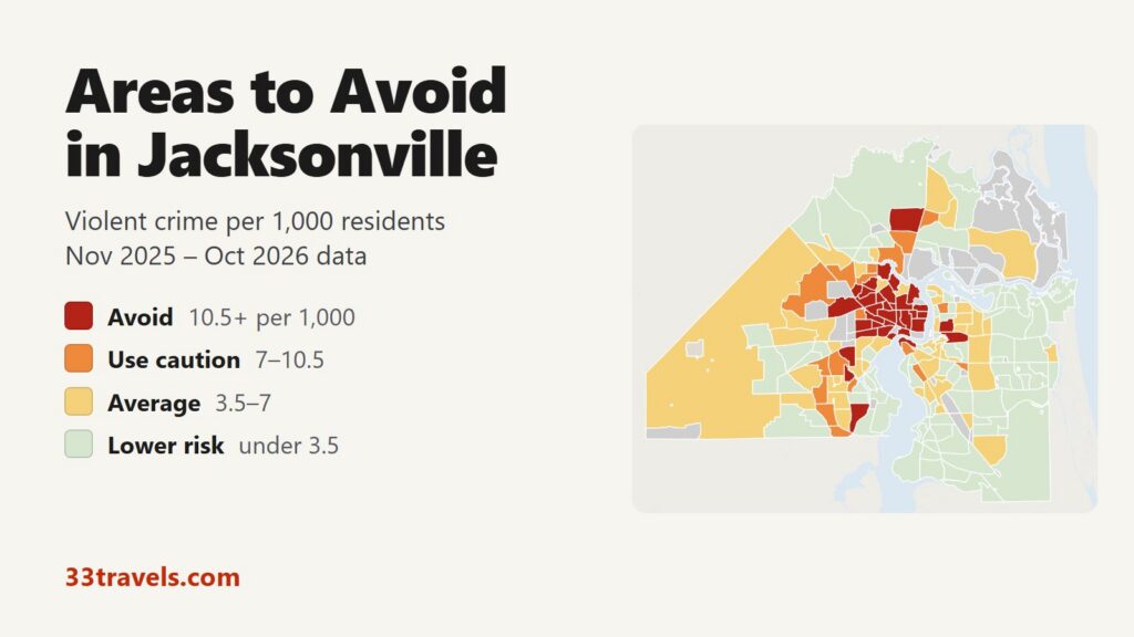
The areas to avoid in Jacksonville sit north and west of Downtown. They take in the historic neighborhoods just north of Downtown, the Northwest along Moncrief Road and Martin Luther King Jr. Parkway and the older Westside along Beaver Street, with smaller pockets in Arlington, near Normandy Boulevard and in the far north near the airport. Between November 2025 and October 2026, 36 neighborhoods recorded 10.5 or more violent crimes per 1,000 residents, twice the city average of 5.2. They house 13% of Jacksonville’s residents but recorded 41% of its violent crime and 30 of its 66 homicide victims.
Neighborhoods to avoid in Jacksonville: Downtown, the Southbank, Brooklyn, Springfield, Hogans Creek, Phoenix, East Jacksonville, Fairfield, Longbranch, Brentwood, Panama Park, 29th & Chase, Moncrief and Mid Westside in and around the urban core. 45th & Moncrief, Grand Park, Royal Terrace, Magnolia Gardens, Edgewood Manor, Carver Manor, Ribault, Lake Forrest, Riverview, Biltmore and College Gardens in the Northwest. Mixon Town, New Town, Robinsons Addition, Lackawanna and Woodstock west of Downtown. Hillcrest, Cedar Hills Estates and Duclay Forest on the Southwest side. Arlington and Woodland Acres east of the river. Jax. North Estates near the airport.
Jacksonville covers more land than any other city in the lower 48 states (see our largest US cities by area), and most of it is suburban: the Southside and Mandarin have no avoid area at all. In FBI data for 2025 the Jacksonville Sheriff’s Office reported 5.19 violent crimes per 1,000 residents, above Miami and Austin and below Boston and Houston. Downtown and the Southbank rate high partly because few people live there while many work, stay in hotels and attend events. Citywide, violent crime rose 2% compared with the 12 months before, while homicides fell 11%.
Jacksonville safety map
Red areas are the places to avoid in Jacksonville and orange areas call for caution. Grey areas are neighborhoods with fewer than 1,000 residents, such as the stadium district, plus Jacksonville Beach, Neptune Beach, Atlantic Beach and Baldwin, which are separate towns. Use the buttons to zoom to Downtown & Urban Core, the Northside, the Westside, Arlington or Southside & Mandarin, and switch the map to Theft & robbery to see where shoplifting and car break-ins cluster. Tap or hover over a neighborhood for its numbers.
Violent crimes per 1,000 residents
Thefts & robberies per area
Tap or hover a neighborhood to see its numbers.
Table of Contents
- Areas to avoid in Jacksonville
- Areas to be careful in
- Is downtown Jacksonville safe?
- Is Riverside and Five Points safe?
- Is San Marco safe?
- Is the Northside of Jacksonville safe?
- Is Jacksonville Beach safe?
- Jacksonville crime rate
- Car break-ins and car theft in Jacksonville
- Safest neighborhoods to stay in Jacksonville
- Clay County, St. Johns County and the Beaches
- Jacksonville safety tips for visitors
- How this map was made
- FAQ
Areas to avoid in Jacksonville
These 36 neighborhoods recorded 10.5 or more violent crimes per 1,000 residents. Most hold 1,000 to 5,000 residents.
| Neighborhood | Council district | Violent crimes per 1,000 | vs. city avg | Homicides | Aggravated assaults | Thefts + robberies |
|---|---|---|---|---|---|---|
| Mid WestsideDistrict 7 | District 7 | 28.4 | 5.5x | 6 | 210 | 376 |
| Hogans CreekDistrict 7 | District 7 | 27.8 | 5.4x | 1 | 53 | 74 |
| Mixon TownDistrict 7 | District 7 | 27.3 | 5.3x | 0 | 27 | 50 |
| 45th & MoncriefDistrict 10 | District 10 | 27.1 | 5.2x | 2 | 77 | 124 |
| PhoenixDistrict 7 | District 7 | 24.3 | 4.7x | 1 | 24 | 35 |
| East JacksonvilleDistrict 7 | District 7 | 22.7 | 4.4x | 1 | 55 | 62 |
| 29th & ChaseDistrict 10 | District 10 | 22.3 | 4.3x | 0 | 41 | 102 |
| RibaultDistrict 10 | District 10 | 19.9 | 3.9x | 0 | 49 | 47 |
| Robinsons AdditionDistrict 9 | District 9 | 19.8 | 3.8x | 1 | 33 | 36 |
| LackawannaDistrict 9 | District 9 | 19.4 | 3.8x | 0 | 59 | 122 |
| BrooklynDistrict 7 | District 7 | 19.3 | 3.7x | 0 | 17 | 197 |
| Grand ParkDistrict 10 | District 10 | 18.9 | 3.7x | 1 | 65 | 143 |
| MoncriefDistrict 10 | District 10 | 18.9 | 3.7x | 0 | 56 | 77 |
| SpringfieldDistrict 7 | District 7 | 17.3 | 3.4x | 3 | 84 | 344 |
| BrentwoodDistrict 10 | District 10 | 17.2 | 3.3x | 5 | 90 | 374 |
| ArlingtonDistrict 1 | District 1 | 16.1 | 3.1x | 2 | 68 | 197 |
| New TownDistrict 7 | District 7 | 15.9 | 3.1x | 0 | 35 | 52 |
| WoodstockDistrict 9 | District 9 | 15.6 | 3.0x | 1 | 68 | 264 |
| Royal TerraceDistrict 10 | District 10 | 15.5 | 3.0x | 0 | 28 | 45 |
| Jax. North EstatesDistrict 8 | District 8 | 13.9 | 2.7x | 0 | 25 | 654 |
| Edgewood ManorDistrict 10 | District 10 | 13.5 | 2.6x | 0 | 28 | 33 |
| FairfieldDistrict 7 | District 7 | 13.4 | 2.6x | 0 | 14 | 11 |
| HillcrestDistrict 9 | District 9 | 13.2 | 2.6x | 1 | 99 | 229 |
| Magnolia GardensDistrict 10 | District 10 | 12.6 | 2.4x | 0 | 45 | 122 |
| RiverviewDistrict 8 | District 8 | 12.1 | 2.3x | 0 | 48 | 99 |
| Carver ManorDistrict 10 | District 10 | 11.8 | 2.3x | 3 | 17 | 56 |
| Cedar Hills EstatesDistrict 9 | District 9 | 11.7 | 2.3x | 0 | 43 | 131 |
| Lake ForrestDistrict 10 | District 10 | 11.7 | 2.3x | 0 | 34 | 95 |
| Duclay ForestDistrict 14 | District 14 | 11.6 | 2.2x | 1 | 40 | 100 |
| Downtown JacksonvilleDistrict 7 | District 7 | 11.4 | 2.2x | 1 | 47 | 192 |
| BiltmoreDistrict 10 | District 10 | 11.3 | 2.2x | 0 | 29 | 57 |
| Panama ParkDistrict 10 | District 10 | 11.3 | 2.2x | 0 | 28 | 76 |
| SouthbankDistrict 5 | District 5 | 11.3 | 2.2x | 0 | 25 | 53 |
| LongbranchDistrict 10 | District 10 | 11.1 | 2.2x | 0 | 21 | 32 |
| Woodland AcresDistrict 1 | District 1 | 10.9 | 2.1x | 0 | 85 | 188 |
| College GardensDistrict 9 | District 9 | 10.7 | 2.1x | 0 | 19 | 34 |
North of Downtown: Springfield, Hogans Creek, Brentwood and the Eastside
Mid Westside has the highest rate in Jacksonville, 28.4 per 1,000, and recorded more violent crime (237 offenses), more aggravated assaults (210) and more homicides (6) than any other neighborhood. It lies along Martin Luther King Jr. Parkway and Kings Road, northwest of Downtown, with 8,350 residents. Hogans Creek (27.8) sits between it and Downtown, around North Davis Street and State Street.
Springfield (17.3), the historic district along North Main Street, recorded 100 violent crimes. Brentwood (17.2) lies north of it along North Pearl Street and Golfair Boulevard and recorded the second-most violent crimes in the city, 117. Panama Park (11.3) continues north from Brentwood. On the east side of the parkway, Phoenix, Fairfield, Longbranch and East Jacksonville form the Eastside, the neighborhoods around Haines Street and Talleyrand Avenue just north of the stadium. East Jacksonville (22.7) is the largest of them.
29th & Chase (22.3) and Moncrief (18.9) lie further north along Moncrief Road between Golfair Boulevard and West 33rd Street.
The Northwest: Moncrief Road, Ribault and Grand Park
Moncrief Road continues northwest into 45th & Moncrief (27.1), between Edgewood Avenue West and Golfair Boulevard. It recorded 89 violent crimes on 3,283 residents. Grand Park (18.9), Royal Terrace (15.5), Magnolia Gardens (12.6), Edgewood Manor (13.5) and Carver Manor (11.8) fill the area to the west and north. Ribault (19.9) surrounds Ribault Scenic Drive and Moncrief Road West, and Lake Forrest (11.7) and Riverview (12.1) extend the cluster north. Biltmore is the western edge.
West of Downtown: Mixon Town, Lackawanna and Woodstock
Between Downtown and Cassat Avenue, five neighborhoods rate avoid along Beaver Street and Edgewood Avenue. Mixon Town (27.3) has the highest rate on the Westside: 31 violent crimes among 1,137 residents. New Town (15.9) borders Mid Westside and holds the Edward Waters University campus. Robinsons Addition (19.8), Lackawanna (19.4) and Woodstock (15.6) run west from there. Lackawanna lies just north of Riverside.
The Southwest: Hillcrest, Cedar Hills Estates and Duclay Forest
Hillcrest (13.2) sits between Normandy Boulevard and Cassat Avenue, about 9 km southwest of Downtown. It recorded 106 violent crimes, much of it at a single apartment address on LaBelle Street. Cedar Hills Estates (11.7) lies just south of it. Duclay Forest (11.6) is further south, next to Wesconnett and Oak Hill.
Arlington and Jax. North Estates
Arlington (16.1) has the highest rate east of the river. The official neighborhood of that name is small, along the Arlington Expressway and Arlington Road, and does not include the larger area most people call Arlington. Woodland Acres (10.9) borders it to the south, between the Arlington Expressway and Atlantic Boulevard, and recorded 85 aggravated assaults.
Jax. North Estates (13.9) has the highest rate on the Northside, but most of its crime is theft: 645 thefts against 34 violent crimes, most of them at the River City Marketplace shops on City Station Drive and City Square Drive.
Areas to be careful in
These 18 neighborhoods recorded 7 to 10.5 violent crimes per 1,000 residents. Together with the avoid areas they hold 22% of residents and 55% of violent crime. Most are Westside neighborhoods next to the avoid areas, such as Hyde Park, Normandy Manor and Jacksonville Heights. Highlands, on the Northside near Dunn Avenue and Lem Turner Road, recorded 105 violent crimes, more than all but three neighborhoods, but its 11,126 residents keep its rate below the avoid line.
| Neighborhood | Council district | Violent crimes per 1,000 | vs. city avg | Homicides | Aggravated assaults | Thefts + robberies |
|---|---|---|---|---|---|---|
| Argyle ForrestDistrict 14 | District 14 | 10.1 | 2.0x | 0 | 37 | 137 |
| HighlandsDistrict 8 | District 8 | 9.4 | 1.8x | 4 | 92 | 390 |
| Normandy ManorDistrict 9 | District 9 | 9.3 | 1.8x | 0 | 43 | 159 |
| AllendaleDistrict 9 | District 9 | 9.1 | 1.8x | 0 | 17 | 88 |
| Kilarney ShoresDistrict 4 | District 4 | 9.0 | 1.7x | 0 | 11 | 100 |
| Cisco GardensDistrict 12 | District 12 | 8.9 | 1.7x | 0 | 8 | 55 |
| Hyde ParkDistrict 9 | District 9 | 8.6 | 1.7x | 0 | 68 | 191 |
| Arlington ManorDistrict 1 | District 1 | 8.3 | 1.6x | 0 | 36 | 87 |
| Lincoln HillsDistrict 10 | District 10 | 8.3 | 1.6x | 0 | 34 | 75 |
| Turtle CreekDistrict 8 | District 8 | 8.2 | 1.6x | 0 | 52 | 89 |
| DuvalDistrict 8 | District 8 | 7.8 | 1.5x | 1 | 29 | 68 |
| Confederate PointDistrict 9 | District 9 | 7.7 | 1.5x | 0 | 24 | 64 |
| HarborviewDistrict 10 | District 10 | 7.7 | 1.5x | 0 | 13 | 91 |
| Osceola ForrestDistrict 10 | District 10 | 7.5 | 1.5x | 0 | 13 | 24 |
| Pine ForrestDistrict 5 | District 5 | 7.5 | 1.5x | 0 | 13 | 89 |
| Jacksonville HeightsDistrict 9 | District 9 | 7.2 | 1.4x | 2 | 78 | 258 |
| McGirts CreekDistrict 14 | District 14 | 7.1 | 1.4x | 0 | 31 | 241 |
| San MarcoDistrict 5 | District 5 | 7.1 | 1.4x | 0 | 15 | 106 |
Is downtown Jacksonville safe?
Downtown rates avoid, but its rate of 11.4 counts only its 5,109 residents, not the office workers, jurors, hotel guests and event crowds. Theft is far more common than violence: 182 thefts against 58 violent crimes in 12 months.
Two men were shot after a fight near East Bay and Market Streets at 3:21 a.m. on July 12, 2026 (News4JAX), and two teenagers were shot near Friendship Fountain on the Southbank at 12:30 a.m. on January 1, 2026, during the New Year’s Eve celebration (News4JAX). JSO added bicycle and mounted patrols Downtown in 2025. Across the Downtown & Urban Core view, violent crime peaks at 9 p.m.
The Southbank (11.3) faces Downtown across the river. It holds the Riverwalk, Friendship Fountain, hotels, offices and condo towers, and has only 2,665 residents. Midtown, which holds EverBank Stadium and VyStar Veterans Memorial Arena, and LaVilla, west of the Downtown core, have too few residents to rate. EverBank Stadium is under renovation, and the Jaguars play their 2027 home games in Orlando (NFL.com).
Is Riverside and Five Points safe?
Yes, with care for your car. Riverside (5.4) sits near the city average, and Avondale (0.9), to its south along the river, has the lowest rate in the urban core. The Five Points bars and the Riverside Arts Market are in Riverside. The main risk is property crime: Riverside recorded 276 thefts, a quarter of them from parked cars, and a string of overnight break-ins hit Five Points restaurants in October 2025 (News4JAX).
Brooklyn (19.3), the strip along Riverside Avenue between Riverside and Downtown, rates avoid on a small count: 22 violent crimes and 192 thefts among 1,142 residents.
Is San Marco safe?
Yes. San Marco (7.1) rates caution on 18 violent crimes among 2,545 residents, a count that includes the visitors to the shops and restaurants of San Marco Square. Its most common crime is theft (103). South Riverside (3.4) and Miramar (1.7), the residential neighborhoods next to it, rate lower risk.
Is the Northside of Jacksonville safe?
It depends on how far north. The neighborhoods just north of Downtown, from Springfield to Panama Park, are the core of the avoid zone. Further north the Northside turns suburban: the Northside view rates 4.5 violent crimes per 1,000, below the city average. The Jacksonville Zoo, Oceanway and the JAX Airport Area are in this part of the city. The exceptions are Jax. North Estates, a shopping-theft hotspot, and Highlands and Turtle Creek, which rate caution.
Is Jacksonville Beach safe?
Jacksonville Beach, Neptune Beach and Atlantic Beach are separate cities with their own police departments, so they are grey on the map and their crimes are not in JSO’s data. In FBI data for 2025, Jacksonville Beach police reported a lower violent crime rate than the Sheriff’s Office (see the suburbs table). Jacksonville Beach adopted a zero-tolerance policy before spring break 2025 after three shootings on March 17, 2024, and its chief said spring break 2025 “was not an issue” (News4JAX).
Jacksonville crime rate
JSO recorded 5,047 murders, robberies and aggravated assaults between November 2025 and October 2026, 5.2 per 1,000 residents, and 66 homicide victims. Compared with the 12 months before, aggravated assaults rose 3%, robberies fell 3% and homicides fell 11%. JSO’s year-end release counted 59 murders in 2024 (JSO), a figure its later records and FBI data put at 63. News4JAX counted 79 murders in 2025, and 110 deaths including justifiable homicides and police shootings (News4JAX).
The urban core is the center of violent crime: the Downtown & Urban Core view rates 14.8 per 1,000, against 7.3 for the Westside, 3.7 for Arlington and 2.4 for Southside & Mandarin. Of the 14 City Council districts, District 10, which covers the Northwest along Moncrief Road, has the highest rate, 13.2, followed by District 7, which takes in Downtown and the Eastside, at 12.4. Districts 3 and 6, on the Southside and in Mandarin, have the lowest, 1.1 and 1.3. Southside & Mandarin has no avoid area.
Car break-ins and car theft in Jacksonville
Car break-ins are a larger risk to visitors than violent crime. JSO recorded 3,253 thefts from vehicles in 12 months, 18% of all thefts, up 5% on the year before. They concentrate around shopping centers on the Southside and in Arlington rather than in the avoid areas: Baymeadows had the most, followed by Regency, around the Regency Square mall. Vehicle thefts fell 24% to 1,968, with the most in Highlands. The busiest areas for shoplifting and other theft are Regency, Windy Hill, home of the St. Johns Town Center, and Jax. North Estates.
Safest neighborhoods to stay in Jacksonville
Close to Downtown, Avondale and Ortega along the river and South Riverside and Miramar next to San Marco rate lower risk. Riverside, with the Five Points bars, sits near the city average. For a hotel near shopping and offices, the Southside around Deerwood, Windy Hill and the St. Johns Town Center rates below the city average for violent crime, though theft from parked cars is common there. Mandarin, in the far south along the river, has one of the lowest rates in the city.
| Neighborhood | Council district | Violent crimes per 1,000 | vs. city avg | Homicides | Aggravated assaults | Thefts + robberies |
|---|---|---|---|---|---|---|
| AvondaleDistrict 7 | District 7 | 0.9 | 0.2x | 0 | 4 | 38 |
| OrtegaDistrict 7 | District 7 | 0.0 | 0.0x | 0 | 0 | 8 |
| South RiversideDistrict 5 | District 5 | 3.4 | 0.7x | 0 | 8 | 17 |
| MiramarDistrict 5 | District 5 | 1.7 | 0.3x | 0 | 7 | 13 |
| RiversideDistrict 7 | District 7 | 5.4 | 1.0x | 0 | 48 | 282 |
| DeerwoodDistrict 11 | District 11 | 1.6 | 0.3x | 0 | 18 | 141 |
| Windy HillDistrict 4 | District 4 | 3.6 | 0.7x | 0 | 47 | 657 |
| Town Center EastDistrict 3 | District 3 | 0.3 | 0.1x | 0 | 3 | 20 |
| Southside EastDistrict 11 | District 11 | 0.7 | 0.1x | 0 | 6 | 109 |
| MandarinDistrict 6 | District 6 | 0.3 | 0.1x | 0 | 3 | 46 |
Clay County, St. Johns County and the Beaches
Jacksonville has no large suburbs of its own: its consolidation with Duval County in 1968 left only the three beach towns and Baldwin outside the city. The suburbs are the neighboring counties, policed by sheriffs. Together with the beach police departments they reported 1.46 violent crimes per 1,000 residents in 2025, against 5.19 for the Sheriff’s Office in the same FBI data. St. Johns County, which includes Ponte Vedra and the area around St. Augustine, has the lowest rate of the three county sheriffs.
| City | Population | Violent crimes | Per 1,000 | Year |
|---|---|---|---|---|
| Jacksonville Sheriff's Office | 1,008,920 | 5,239 | 5.2 | 2025 |
| Jacksonville Beach PD | 23,585 | 80 | 3.4 | 2025 |
| Clay County SO | 218,420 | 529 | 2.4 | 2025 |
| Atlantic Beach PD | 13,226 | 20 | 1.5 | 2025 |
| Nassau County SO | 92,440 | 112 | 1.2 | 2025 |
| St. Johns County SO | 322,319 | 245 | 0.8 | 2025 |
| Neptune Beach PD | 6,991 | 5 | 0.7 | 2025 |
Murder, rape, robbery and aggravated assault reported to the FBI by each agency, per 1,000 residents of the population the agency reports. Source: FBI Crime Data Explorer. Agencies that report no complete year are left out.
Jacksonville safety tips for visitors
- Take a rideshare after dark between Downtown, the Southbank, Five Points and San Marco rather than walking through the blocks between them.
- Plan around transit: the Skyway monorail has been paused since November 2, 2026, and the free NAVI shuttle on Bay Street pauses on December 31, 2026 (JTA).
- Leave nothing in sight in a parked car, especially at the St. Johns Town Center, Regency, River City Marketplace and Five Points.
- Stay in Riverside, Avondale, Deerwood, near the St. Johns Town Center or at the Beaches, or pick a Downtown hotel on the river and use rideshares at night.
- Call 9-1-1 for emergencies and the Sheriff’s Office non-emergency line, 904-630-0500, for anything else.
How this map was made
Crime counts come from the Jacksonville Sheriff’s Office transparency portal for November 2025 through October 2026. JSO publishes each offense with a hundred-block address and states that the layer is not official crime data. Its public data leaves out rape and other sexual offenses, so violent crime here means murder, robbery and aggravated assault. Murders and aggravated assaults are counted once per victim, the FBI rule, and robberies once per incident. Population is the 2020 Census count by block, and the neighborhoods are the City of Jacksonville’s official neighborhood map, with large unmapped stretches of the Southside and the far west grouped into areas such as Far Westside and Southside East.
The tiers are Avoid (10.5 or more violent crimes per 1,000 residents), Use caution (7 to 10.5), Average (3.5 to 7) and Lower risk. Crimes handled by the University of North Florida and Florida State College police, the Jacksonville Aviation Authority police at the airport, Naval Station Mayport security and the Florida Highway Patrol on the interstates are not in JSO’s data. The suburban table uses each department’s reports to the FBI’s Crime Data Explorer. The theft layer counts thefts and robberies, not rates.
We built the same map for the areas to avoid in Chicago, the areas to avoid in New York City, the areas to avoid in San Francisco, the areas to avoid in Los Angeles, the areas to avoid in Miami, the areas to avoid in Atlanta, the areas to avoid in Baltimore, the areas to avoid in Detroit, the areas to avoid in Austin, the areas to avoid in Philadelphia, the areas to avoid in St. Louis, the areas to avoid in Boston, the areas to avoid in Denver, the areas to avoid in Houston, the areas to avoid in San Diego, the areas to avoid in Milwaukee and the areas to avoid in Buffalo.
FAQ
What are the worst neighborhoods in Jacksonville?
By violent crime per resident, Mid Westside (28.4 per 1,000), Hogans Creek, Mixon Town and 45th & Moncrief rank highest. All four lie within a few miles northwest and west of Downtown. Mid Westside also recorded the most violent crimes and homicides of any neighborhood.
Is Jacksonville safe for tourists?
Mostly, yes. Riverside, Avondale, the St. Johns Town Center, Mandarin and the Beaches are outside the avoid areas, which are residential neighborhoods north and west of Downtown. Downtown and the Southbank rate avoid because few people live there, and theft is their most common crime.
What part of Jacksonville has the most crime?
The urban core and the Northwest. The Downtown & Urban Core view rates 14.8 violent crimes per 1,000 residents, almost three times the city average of 5.2. City Council District 10, along Moncrief Road, has the highest rate of the 14 districts.
What is the safest part of Jacksonville?
The Southside and Mandarin. That part of the city rates 2.4 violent crimes per 1,000 residents and has no avoid area. Council Districts 3 and 6 have the lowest rates in the city.
Is it safe to walk around downtown Jacksonville at night?
Stay on the Riverwalk, in the hotel blocks and with event crowds, and take a rideshare between neighborhoods. Two shootings in 2026 happened after midnight, one near East Bay and Market Streets and one near Friendship Fountain on New Year's Eve.
Is Arlington in Jacksonville safe?
Most of it is. The small official neighborhood named Arlington (16.1) and Woodland Acres next to it rate avoid, but the Arlington view as a whole rates 3.7 per 1,000, below the city average.
Is Jacksonville's crime rate going up or down?
Mixed. Between November 2025 and October 2026 violent crime rose 2% on the year before, while homicides fell 11% and vehicle thefts fell 24%.
Why is rape missing from the Jacksonville crime numbers?
The Jacksonville Sheriff's Office does not publish rape or other sexual offenses in its public crime data. The violent crime counts on this map are murder, robbery and aggravated assault.