South Korea has 16 first-level divisions, grouped on this map into 6 regions. The count fell from 17 on 1 July 2026, when Gwangju and South Jeolla merged into Jeonnam-Gwangju Special Metropolitan City. Only 8 of the 16 are provinces. South Korea’s population was 51,817,499 on 1 November 2025, and its capital is Seoul. On this Korea map, click a region or province to see its capital, population, area and landmarks, or type a city to find where it is.
The 8 provinces are 5 ordinary provinces and 3 special self-governing provinces (Gangwon, Jeonbuk and Jeju). The other 8 divisions are Seoul, five metropolitan cities, Jeonnam-Gwangju and Sejong. They are cities, but they rank level with the provinces and sit under no province.
How to use this map of South Korea
Every region and province on this South Korea map is clickable.
- Explore a region: click or tap it to open its divisions, population, area, landmarks and food. Switch the Regions / Provinces toggle to see all 16 divisions on their own.
- Compare data: use View by to color the map by region, type, population, density, area, GDP per capita or UNESCO sites. The density layer shows Seoul at 15,391.7 people per km² against 90.2 in Gangwon.
- Find a city: type a city in the search box to see its division and region. It answers questions such as which province Suwon, Pohang or Cheonan is in.
- Print it: Printables has a labelled map of South Korea and blank maps for practice, all in A4.
- Take the data: Export downloads all 16 divisions as CSV with a citation.
We publish the same kind of map for other countries: regions of Japan, across the sea to the east, India, Australia, Brazil, Italy, Switzerland and the map of Canada. For the continent, see Asia and the regions of Asia, and for everything we have on the country, South Korea.
The 6 regions of South Korea
The six regions are traditional groupings of whole divisions: the Capital Area (Sudogwon), Gangwon, Chungcheong, Honam, Yeongnam and Jeju. They are used in everyday speech and planning, and they have no government. Click a column heading to sort.
| Region | Provinces and cities | Population | Area (km²) | Share of population |
|---|---|---|---|---|
| Capital Area | 1 special city, 1 metropolitan city and 1 province | 26,376,526 | 11,883 | 50.9% |
| Gangwon | 1 special self-governing province | 1,518,938 | 16,831 | 2.9% |
| Chungcheong | 1 metropolitan city, 1 special self-governing city and 2 provinces | 5,767,491 | 16,660 | 11.1% |
| Honam | 1 special metropolitan city and 1 special self-governing province | 4,962,477 | 20,943 | 9.6% |
| Yeongnam | 3 metropolitan cities and 2 provinces | 12,522,713 | 32,306 | 24.2% |
| Jeju | 1 special self-governing province | 669,354 | 1,850 | 1.3% |
The Capital Area has 26,376,526 people, 50.9% of the country, on 11.8% of the land. Yeongnam is the largest region by area (32,306.0 km², 32.2%) and holds 24.2% of the people. Gangwon has 16.8% of the area and 2.9% of the population. Between the 2020 and 2025 censuses Chungcheong grew 2.1% and the Capital Area 1.3%, while Honam fell 2.1% and Yeongnam 2.7%. The Honam figures add Gwangju and South Jeolla, which were separate in both censuses.
The regions of South Korea one by one
Capital Area (Seoul, Incheon, Gyeonggi) has 26,376,526 people around the Han River estuary. Gyeonggi is the most populous province at 13,967,870, with 28 cities and 3 counties. Seoul has 9,315,066 in 25 districts, and Incheon, a Yellow Sea port with 3,093,590, grew 5.0% since 2020. The Yellow Sea is shared with other countries (see Yellow Sea bordering countries), and the Han is one of the rivers in South Korea. Gyeongbokgung, Hwaseong Fortress and Namhansanseong are here.
Gangwon is the mountainous north-east, called Gwandong east of the Taebaek Mountains. Gangwon State has 1,518,938 people on 16,831.2 km², the second-largest area and the lowest density of any division. It hosted the 2018 Winter Olympics at Pyeongchang and Gangneung. The historic Gangwon province continues north of the border into North Korea, and our list of countries that border North Korea covers that frontier.
Chungcheong (Daejeon, Sejong, North Chungcheong, South Chungcheong), also called Hoseo, has 5,767,491 people in the middle of the country. North Chungcheong is the only landlocked province. South Chungcheong was the heartland of the Baekje kingdom and has 2,249,201 people. Sejong, a planned city that houses many national ministries, grew 10.9% in five years.
Honam (Jeonbuk, Jeonnam-Gwangju) is the south-west and the old Jeolla area, with 4,962,477 people. Jeonbuk State has 1,752,029 and is known for Jeonju bibimbap and its hanok village. Jeonnam-Gwangju has 3,210,448 (Gwangju plus South Jeolla, summed) and Suncheon Bay.
Yeongnam (Busan, Daegu, Ulsan, North Gyeongsang, South Gyeongsang), the old Gyeongsang area, is the south-east, with 12,522,713 people. Busan has 3,235,362 and is the main port. North Gyeongsang is the largest province at 18,428.2 km² and holds the former Silla capital, Gyeongju. It also administers Ulleungdo. Dokdo (Takeshima in Japanese) is administered by South Korea as part of Ulleung County in this province, and Japan claims it. Ulsan has the highest GDP per capita of any division.
Jeju is a region of one division: a volcanic island south of the mainland with 669,354 people on 1,850.1 km². Hallasan, the highest mountain in South Korea, rises here. Jeju has two administrative cities, Jeju (491,186) and Seogwipo (178,168).
All 16 provinces and cities of South Korea
The table lists every division with its type, region, population and area. Click a heading to sort, or a division name to open its card on the map. Population is the census figure for 1 November 2025, and area is registered land area at 31 December 2025. Jeonnam-Gwangju has no ISO 3166-2 code yet, so its code shows N/A.
All 16 provinces and cities
| Code | Province or city | Type | Capital | Region | Population | Area (km²) | GRDP per capita (KRW) |
|---|---|---|---|---|---|---|---|
| SE | Seoul | Special city | Seoul | Capital Area | 9,315,066 | 605 | 61,220,000 |
| BS | Busan | Metropolitan city | Busan | Yeongnam | 3,235,362 | 772 | 37,080,000 |
| DG | Daegu | Metropolitan city | Daegu | Yeongnam | 2,363,643 | 1,500 | 31,370,000 |
| IC | Incheon | Metropolitan city | Incheon | Capital Area | 3,093,590 | 1,070 | 41,190,000 |
| JG | Jeonnam-Gwangju | Special metropolitan city | Gwangju | Honam | 3,210,448 | 12,865 | 49,440,000 |
| DJ | Daejeon | Metropolitan city | Daejeon | Chungcheong | 1,469,299 | 540 | 38,220,000 |
| US | Ulsan | Metropolitan city | Ulsan | Yeongnam | 1,103,509 | 1,063 | 85,190,000 |
| SJ | Sejong | Special self-governing city | Sejong | Chungcheong | 392,471 | 465 | 44,610,000 |
| GG | Gyeonggi | Province | Suwon | Capital Area | 13,967,870 | 10,208 | 47,000,000 |
| GW | Gangwon | Special self-governing province | Chuncheon | Gangwon | 1,518,938 | 16,831 | 42,560,000 |
| CB | North Chungcheong | Province | Cheongju | Chungcheong | 1,656,520 | 7,407 | 56,330,000 |
| CN | South Chungcheong | Province | Hongseong | Chungcheong | 2,249,201 | 8,248 | 67,760,000 |
| JB | Jeonbuk | Special self-governing province | Jeonju | Honam | 1,752,029 | 8,078 | 37,980,000 |
| GB | North Gyeongsang | Province | Andong | Yeongnam | 2,567,565 | 18,428 | 52,300,000 |
| GN | South Gyeongsang | Province | Changwon | Yeongnam | 3,252,634 | 10,544 | 46,550,000 |
| JJ | Jeju | Special self-governing province | Jeju City | Jeju | 669,354 | 1,850 | 39,910,000 |
South Korea population, area and density
South Korea had 51,817,499 residents on 1 November 2025 on 100,472.4 km², or 515.7 per km². The census counts everyone resident, foreign residents included. That is 11,637 fewer than the 51,829,136 counted in 2020, so the national total is flat while the distribution moves.
| Measure | South Korea |
|---|---|
| Population, census of 1 November 2025 | 51,817,499 |
| Population, census of 1 November 2020 | 51,829,136 |
| Change, 2020 to 2025 | 11,637 fewer people |
| Area, 31 December 2025 | 100,472.4 km² |
| Density | 515.7 per km² |
| First-level divisions | 16 (8 provinces, 8 city-level) |
| Cities, counties and districts | 229 on 2 November 2026 |
| GDP per capita, 2024 provisional | KRW 49,480,000 |
| UNESCO World Heritage properties | 17 |
Gyeonggi (27.0%) and Seoul (18.0%) hold 44.9% of the population between them. 11 of the 16 divisions lost people since 2020. The five that grew were Sejong (+10.9%), Incheon (+5.0%), Gyeonggi (+3.4%), South Chungcheong (+3.3%) and North Chungcheong (+1.5%). Busan fell most, -3.4%. The Jeonnam-Gwangju figures for both years are Gwangju and South Jeolla added together, and the 2020 figures for Daegu and North Gyeongsang are restated to move Gunwi County to Daegu.
Capitals of South Korea and its provinces
Seoul is the capital of South Korea and its largest city, with 9,315,066 residents. Sejong (392,471) houses many national ministries but is a separate division, and it has the fewest people of the 16. The provinces have their own capitals, and in three of the eight the capital is not the largest city:
| Province | Capital | Largest city |
|---|---|---|
| Gyeonggi | Suwon | Suwon |
| Gangwon | Chuncheon | Wonju |
| North Chungcheong | Cheongju | Cheongju |
| South Chungcheong | Hongseong | Cheonan |
| Jeonbuk | Jeonju | Jeonju |
| North Gyeongsang | Andong | Pohang |
| South Gyeongsang | Changwon | Changwon |
| Jeju | Jeju City | Jeju City |
Gangwon’s capital Chuncheon (293,524) is smaller than Wonju (367,326). South Chungcheong’s government moved from Daejeon to Naepo New Town in 2012, and Naepo straddles Hongseong and Yesan counties. North Gyeongsang’s government moved from Daegu to Andong (154,183) in 2016, and Pohang (490,882) is larger. Jeonnam-Gwangju is not a province and names no single seat: its government is split among offices in Gwangju, Muan and Eastern Jeonnam (Suncheon), and Gwangju is the largest city.
Kinds of division: special city, metropolitan city and province
The 16 divisions come in six types. The Korean name of each division ends in the term shown.
| Type | Korean name ending | Divisions | Which | Population |
|---|---|---|---|---|
| Special city | 특별시 | 1 | Seoul | 9,315,066 |
| Metropolitan city | 광역시 | 5 | Busan, Daegu, Incheon, Daejeon, Ulsan | 11,265,403 |
| Special metropolitan city | 통합특별시 | 1 | Jeonnam-Gwangju | 3,210,448 |
| Special self-governing city | 특별자치시 | 1 | Sejong | 392,471 |
| Province | 도 | 5 | Gyeonggi, North Chungcheong, South Chungcheong, North Gyeongsang, South Gyeongsang | 23,693,790 |
| Special self-governing province | 특별자치도 | 3 | Gangwon, Jeonbuk, Jeju | 3,940,321 |
Special self-governing status is a rank a division is granted: Jeju received it in 2006, Gangwon in 2023 and Jeonbuk in 2024. Sejong has no cities, counties or districts below it. Metropolitan cities such as Busan, Daegu, Incheon and Ulsan contain districts (gu) and also a few counties (gun). Jeonnam-Gwangju is the only division that has cities, districts and counties together.
Does South Korea have states or provinces?
South Korea has provinces: 5 provinces and 3 special self-governing provinces, 8 in all. Until 30 June 2026 it had 9, because South Jeolla was still a province. Anything called the states of South Korea means the same 16 divisions, because the provinces share the first level with 8 cities of equal rank. The divisions are not federal states and have no sovereignty of their own.
Two English names cause confusion. Gangwon State and Jeonbuk State are provinces whose special self-governing status came with an English name change, in 2023 and 2024. Below the 16 divisions are 229 cities, counties and districts.
Jeonnam-Gwangju: the 2026 merger that made 16 divisions
On 1 July 2026 Gwangju Metropolitan City and South Jeolla Province merged into Jeonnam-Gwangju Special Metropolitan City (전남광주통합특별시). It is the first merger of first-level divisions in Korea. The special act passed the National Assembly in early March 2026 by 159 votes to 2, with 14 abstentions, and the cabinet approved it on 5 March. The country went from 17 divisions to 16, and from 9 provinces to 8.
| Residents (1 Nov 2025) | Area (km²) | Cities, counties, districts | |
|---|---|---|---|
| Gwangju Metropolitan City, to 30 June 2026 | 1,431,903 | 500.9 | 5 districts (gu) |
| South Jeolla Province, to 30 June 2026 | 1,778,545 | 12,364.3 | 5 cities (si) and 17 counties (gun) |
| Jeonnam-Gwangju, from 1 July 2026 | 3,210,448 (sum) | 12,865.2 (sum) | 5 si, 5 gu and 17 gun |
The census was taken on the old borders, so the 2025 figures for Jeonnam-Gwangju on this page add the two published results. The merged division has the fifth-highest population of the 16 (behind Gyeonggi, Seoul, South Gyeongsang and Busan) and the third-largest area (behind North Gyeongsang and Gangwon). News reports at the launch quoted about 3.23 million. That is a resident-registration count, which excludes foreign residents, and not comparable with the census figure. Gwangju no longer exists as a city: its five districts are direct subdivisions of Jeonnam-Gwangju, and the combined unit covers 27 cities, counties and districts.
Two more mergers are not law. The Daegu-Gyeongbuk and Daejeon-Chungnam bills passed the Assembly’s Public Administration and Security Committee on 12 February 2026. On 24 February the Legislation and Judiciary Committee put both on hold and passed only the Jeonnam-Gwangju act. The Daegu-Gyeongbuk bill was still pending in that committee on 8 September 2026. This map keeps Daegu, North Gyeongsang, Daejeon and South Chungcheong as four separate divisions.
Other ways to divide South Korea
Megaregions: the 5+2 split
Regional policy often uses five megaregions plus two special regions, called 5+2. The first five are the Capital Area, Chungcheong, Honam, Daegyeong (Daegu and North Gyeongsang) and Dongnam (Busan, Ulsan and South Gyeongsang). The plus two are Gangwon and Jeju. Yeongnam is split in two in this scheme. The government’s 2025 “5 poles, 3 special areas” strategy moves Jeonbuk out of the Honam pole and into a special area with Gangwon and Jeju. These are planning groups, not levels of government.
| Megaregion | Divisions | Population | Share |
|---|---|---|---|
| Capital Area | Seoul, Incheon, Gyeonggi | 26,376,526 | 50.9% |
| Chungcheong | Daejeon, Sejong, North Chungcheong, South Chungcheong | 5,767,491 | 11.1% |
| Honam | Jeonbuk, Jeonnam-Gwangju | 4,962,477 | 9.6% |
| Daegyeong | Daegu, North Gyeongsang | 4,931,208 | 9.5% |
| Dongnam | Busan, Ulsan, South Gyeongsang | 7,591,505 | 14.7% |
| Gangwon | Gangwon | 1,518,938 | 2.9% |
| Jeju | Jeju | 669,354 | 1.3% |
The Eight Provinces of Joseon
Before 1896 Korea was divided into Eight Provinces, set in 1413. Five of the eight are in South Korea today, Gangwon only in part, and their names survive in Chungcheong, Gyeongsang, Jeolla and Gangwon.
| Joseon province (1413) | Today |
|---|---|
| Gyeonggi | Seoul, Incheon, Gyeonggi |
| Chungcheong | Daejeon, Sejong, North Chungcheong, South Chungcheong |
| Gangwon | Gangwon State (the northern part is in North Korea) |
| Gyeongsang | Busan, Daegu, Ulsan, North Gyeongsang, South Gyeongsang |
| Jeolla | Jeonbuk, Jeonnam-Gwangju, and Jeju until 1946 |
| Hwanghae, P’yongan, Hamgyong | North Korea |
Dialect areas
Dialect maps follow the older provinces more than the modern divisions: Seoul-Gyeonggi, Gangwon, Chungcheong, Jeolla, Gyeongsang and Jeju. Gyeongsang speech keeps a pitch accent, and Jeju speech is often treated as a language of its own. Our list of indigenous languages in South Korea goes further. Travelers can start with the useful Korean phrases for tourists.
Tourist regions
Travel sites group the country by sights, not by borders, and the boundaries are approximate. This table maps the usual groupings to divisions. For ideas on what to do, see adventurous things to do in South Korea.
| Tourist area (approximate) | Divisions | Known for |
|---|---|---|
| Seoul and surroundings | Seoul, Gyeonggi, Incheon | Gyeongbokgung, Changdeokgung, Hwaseong Fortress, Namhansanseong, Incheon International Airport |
| Gangwon coast and mountains | Gangwon | Seoraksan, Odaesan, Gyeongpo Beach, Nami Island |
| Busan and the south-east coast | Busan, Ulsan, South Gyeongsang | Haeundae Beach, Gamcheon Culture Village, Jagalchi Market, Haeinsa |
| Gyeongju and Andong | North Gyeongsang | Bulguksa, Seokguram, Hahoe Folk Village |
| Jeonju and the south-west | Jeonbuk, Jeonnam-Gwangju | Jeonju Hanok Village, Suncheon Bay, Mudeungsan, Naejangsan |
| Jeju Island | Jeju | Hallasan, lava tubes |
Largest and smallest divisions
| Measure | Highest | Lowest |
|---|---|---|
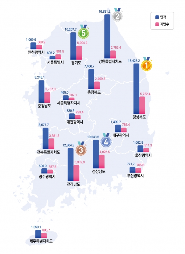
| Area | North Gyeongsang, 18,428.2 km² | Sejong, 465.0 km² |
| Population | Gyeonggi, 13,967,870 | Sejong, 392,471 |
| Density per km² | Seoul, 15,391.7 | Gangwon, 90.2 |
| GDP per capita, 2024 | Ulsan, KRW 85,190,000 | Daegu, KRW 31,370,000 |
| Population change, 2020 to 2025 | Sejong, +10.9% | Busan, -3.4% |
| Cities, counties and districts | Gyeonggi, 31 | Sejong, 0; Jeju, 2 |
Seoul is the third-smallest by area (605.2 km², after Daejeon at 539.8 and Sejong at 465.0) and has 9,315,066 people. North Gyeongsang and Gangwon together cover 35.1% of the land but hold 7.9% of the population.
GDP per capita runs from KRW 31,370,000 in Daegu to KRW 85,190,000 in Ulsan, against a national KRW 49,480,000 (2024, provisional). South Chungcheong (KRW 67,760,000) and Seoul (KRW 61,220,000) follow Ulsan. The figure measures output located in a division, not what residents earn, so industrial divisions rank high. The Jeonnam-Gwangju figure (KRW 49,440,000) is our estimate for the combined territory, because the release predates the merger. For the local view, read the poorest cities in South Korea. The GDP layer maps all 16.
How the map of South Korea took shape, 1018 to 2026
The 16-division map is the result of three waves: the 1896 split into 13 provinces, the creation of metropolitan cities between 1946 and 1997, and the status changes and mergers since 2006.
| Year | Change |
|---|---|
| 1018 | Gyeonggi is established under Goryeo. Seoul is separated from it in 1946 and Incheon in 1981. |
| 1413 | Joseon sets the Eight Provinces: Chungcheong, Gangwon, Gyeonggi, Gyeongsang, Jeolla, Hwanghae, P’yongan and Hamgyong. They stay unchanged until 1895. |
| 1896 | Thirteen provinces replace 23 districts. Chungcheong, Gyeongsang and Jeolla are each split into a north and a south province. |
| 1946 | Seoul becomes a special city, and Jeju becomes a province separate from Jeolla. |
| 1963 to 1989 | Busan (1963), Gwangju (1986) and Daejeon (1989) become directly governed cities. |
| 1995 | Busan, Daegu, Incheon, Gwangju and Daejeon become metropolitan cities. |
| 1997 | Ulsan becomes a metropolitan city on 15 July, separating from South Gyeongsang. |
| 2006 | Jeju becomes a special self-governing province on 1 July. |
| 2012 | Sejong becomes a special self-governing city on 1 July, cut from areas of South and North Chungcheong. The South Chungcheong government moves from Daejeon to Naepo. |
| 2016 | The North Gyeongsang government moves from Daegu to Andong. |
| 2023 | Gangwon becomes a special self-governing province on 11 June. Gunwi County moves from North Gyeongsang to Daegu on 1 July. |
| 2024 | Jeonbuk becomes a special self-governing province on 18 January. |
| 2026 | On 1 July, Gwangju and South Jeolla merge into Jeonnam-Gwangju, and Incheon reorganises its districts. |
The 2023 transfer of Gunwi County put 22,096 residents (2020 census) into Daegu, which puts Daegu’s area at 1,499.7 km² and leaves North Gyeongsang with 18,428.2 km².
Cities, counties and districts
South Korea had 229 second-level local units on 2 November 2026: 77 cities (si), 82 counties (gun) and 70 autonomous districts (gu). General districts of big cities such as Suwon, Seongnam and Changwon are not local governments and are not counted, so each of those cities counts once. Jeju’s two administrative cities are counted, and Sejong has none.
Gyeonggi has the most (31: 28 cities and 3 counties), then Jeonnam-Gwangju (27) and Seoul (25 districts). On 1 July 2026 Incheon reorganised: Jung and Dong became Jemulpo and Yeongjong, and Seo became Seohae and Geomdan, which leaves Incheon with 9 districts and 2 counties.
Four cities in Gyeonggi have more than a million residents: Suwon (1,221,616), Yongin (1,085,182), Goyang (1,036,961) and Hwaseong (1,027,532). Suwon has more people than Ulsan (1,103,509), a metropolitan city. See the largest cities in South Korea, and at the other end the smallest by population and the smallest by area.
UNESCO World Heritage sites by division
South Korea has 17 UNESCO World Heritage properties. The newest is the Petroglyphs along the Bangucheon Stream, inscribed in 2025. A serial property counts in every division that holds a component, so the lists below add up to 35 entries. Busan, Daejeon and Sejong have none.
| Division | Properties | Names |
|---|---|---|
| North Gyeongsang | 6 | Seokguram Grotto and Bulguksa Temple; Gyeongju Historic Areas; Historic Villages of Korea: Hahoe and Yangdong; Sansa, Buddhist Mountain Monasteries in Korea; Seowon, Korean Neo-Confucian Academies; Gaya Tumuli |
| Jeonbuk | 5 | Gochang, Hwasun and Ganghwa Dolmen Sites; Baekje Historic Areas; Seowon, Korean Neo-Confucian Academies; Getbol, Korean Tidal Flats; Gaya Tumuli |
| Jeonnam-Gwangju | 4 | Gochang, Hwasun and Ganghwa Dolmen Sites; Sansa, Buddhist Mountain Monasteries in Korea; Seowon, Korean Neo-Confucian Academies; Getbol, Korean Tidal Flats |
| South Chungcheong | 4 | Baekje Historic Areas; Sansa, Buddhist Mountain Monasteries in Korea; Seowon, Korean Neo-Confucian Academies; Getbol, Korean Tidal Flats |
| South Gyeongsang | 4 | Haeinsa Temple Janggyeong Panjeon; Sansa, Buddhist Mountain Monasteries in Korea; Seowon, Korean Neo-Confucian Academies; Gaya Tumuli |
| Gyeonggi | 3 | Hwaseong Fortress; Royal Tombs of the Joseon Dynasty; Namhansanseong |
| Seoul | 3 | Jongmyo Shrine; Changdeokgung Palace Complex; Royal Tombs of the Joseon Dynasty |
| Daegu | 1 | Seowon, Korean Neo-Confucian Academies |
| Gangwon | 1 | Royal Tombs of the Joseon Dynasty |
| Incheon | 1 | Gochang, Hwasun and Ganghwa Dolmen Sites |
| Jeju | 1 | Jeju Volcanic Island and Lava Tubes |
| North Chungcheong | 1 | Sansa, Buddhist Mountain Monasteries in Korea |
| Ulsan | 1 | Petroglyphs along the Bangucheon Stream |
North Gyeongsang has six and Jeonbuk five. The Royal Tombs of the Joseon Dynasty span Seoul, Gyeonggi and Gangwon. Sansa, the Buddhist mountain monasteries, are in five divisions, and Seowon, the Neo-Confucian academies, in six. The UNESCO layer counts them per division.
Frequently asked questions
How many provinces does South Korea have?
South Korea has 8 provinces: 5 ordinary provinces (Gyeonggi, North Chungcheong, South Chungcheong, North Gyeongsang and South Gyeongsang) and 3 special self-governing provinces (Gangwon, Jeonbuk and Jeju). With the 8 city-level divisions there are 16 first-level units. Before 1 July 2026 there were 9 provinces and 17 units, because South Jeolla and Gwangju were separate.
What is the capital of South Korea?
Seoul is the capital of South Korea and its largest city, with 9,315,066 residents at the 2025 census. Sejong, with 392,471, houses many national ministries but is a separate special self-governing city.
What is the population of South Korea?
South Korea had 51,817,499 residents on 1 November 2025, according to the register-based census. That is 11,637 fewer than in 2020. Gyeonggi (13,967,870) and Seoul (9,315,066) are the most populous divisions, and the density is 515.7 per km².
What happened to Gwangju and South Jeolla?
They merged on 1 July 2026 into Jeonnam-Gwangju Special Metropolitan City, the first merger of first-level divisions in Korea. The National Assembly passed the special act in early March 2026. The merged division has 3,210,448 residents (the 2025 census totals of the two added together) and 12,865.2 km².
Is Gwangju still a city?
Gwangju is no longer a separate city or a separate division. Its five districts, with 1,431,903 residents, are now direct subdivisions of Jeonnam-Gwangju, and Gwangju is the largest city in the new unit. The unit has no single seat: its government is split among offices in Gwangju, Muan and Eastern Jeonnam (Suncheon).
What are the regions of South Korea?
South Korea has six regions: the Capital Area (Seoul, Incheon and Gyeonggi), Gangwon, Chungcheong, Honam (Jeonbuk and Jeonnam-Gwangju), Yeongnam (Busan, Daegu, Ulsan and the two Gyeongsang provinces) and Jeju. They are traditional groupings of whole divisions and have no government of their own.
Does South Korea have states or provinces?
It has provinces. Eight of the 16 first-level divisions are provinces, and the other eight are cities of equal rank. Gangwon State and Jeonbuk State are provinces with special self-governing status, and their English names changed in 2023 and 2024.
What are the biggest cities in South Korea?
Seoul (9,315,066) is first, followed by Busan (3,235,362), Incheon (3,093,590), Daegu (2,363,643) and Daejeon (1,469,299). Gwangju’s five districts together have 1,431,903, and Suwon, the largest city inside a province, has 1,221,616. Ulsan has 1,103,509.
Is Sejong a province or a city?
Sejong is a special self-governing city. It was created on 1 July 2012 from areas of South Chungcheong and North Chungcheong, has no cities, counties or districts below it, and is counted as one of the 16 first-level divisions. It has 392,471 residents, the fewest of the 16.
Are Daegu-Gyeongbuk and Daejeon-Chungnam also merging?
Not yet. Both bills passed a committee on 12 February 2026, but the Legislation and Judiciary Committee put them on hold on 24 February. The Daegu-Gyeongbuk bill was still pending on 8 September 2026. Neither merger is law, and Daegu, North Gyeongsang, Daejeon and South Chungcheong remain four divisions.
What is the difference between Seoul, the Capital Area and Gyeonggi?
Seoul is a special city with 25 districts. Gyeonggi is the province around it, with 28 cities and 3 counties. The Capital Area (Sudogwon) is the region that adds Incheon to both, with 26,376,526 people, or 50.9% of the country.
Why are Gangwon and Jeonbuk called states?
Gangwon became a special self-governing province on 11 June 2023 and Jeonbuk on 18 January 2024, and both took the English name State. Gangwon State and Jeonbuk State replace Gangwon Province and North Jeolla Province. Gunwi County also moved from North Gyeongsang to Daegu on 1 July 2023.
Sources and methodology
- Population: National Data Office (formerly KOSTAT), 2025 Population and Housing Census, register-based results for 1 November 2025, published 28 July 2026, and the 2020 census for 1 November 2020. Both were published on the old borders. Gwangju and South Jeolla are added together for both years, and the 2020 figures for Daegu and North Gyeongsang move Gunwi County (22,096 residents in 2020) to Daegu. The 16 divisions sum to the national total of 51,817,499.
- Area: MOLIT, 2026 Cadastral Statistics, registered land area at 31 December 2025, including inland water and excluding the unregistered sea and tidal flats. Jeonnam-Gwangju is South Jeolla (12,364.3 km²) plus Gwangju (500.9 km²). Density divides census population by registered area.
- GDP per capita: KOSTAT regional income 2024 (provisional), released 23 December 2025, in won at current prices. Jeonnam-Gwangju is derived from the nominal GRDP and implied populations of Gwangju and South Jeolla.
- Codes and structure: MOIS administrative code files effective 1 July 2026. The merger and the stalled bills follow Korean news reports (Seoul Shinmun, 1 July 2026; Segye Ilbo, 9 September 2026), not the Assembly bill system. ISO 3166-2:KR has no code yet for Jeonnam-Gwangju.
- Boundaries and sub-units: SGIS administrative-dong boundaries, edition of 1 October 2026 (KOGL Type 1; processing by vuski/admdongkor, CC BY 4.0). Dokdo is drawn inside North Gyeongsang, following Korean administration. Japan claims it.
- World Heritage: UNESCO World Heritage Centre, 17 properties, checked on 2 November 2026. Serial properties are listed in every division with a component.
- Cities: populations of the five largest cities, counties or districts per division are 2025 census rows, with coordinates from GeoNames (CC BY 4.0). Incheon’s Seohae District uses the figure reported at its launch.
- Megaregions, historical provinces and tourist areas: the megaregion field is editorial and follows the 5+2 framing. Tourist areas are approximate.
Use the “Cite this page” button in the map to copy a ready-made citation.