
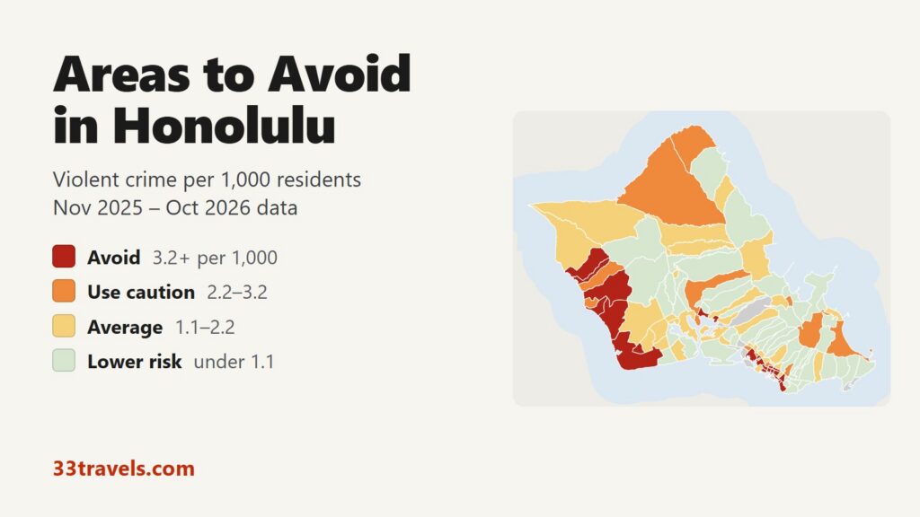
The areas to avoid in Honolulu are in two parts of Oahu: the dense strip of central Honolulu from Kalihi through Downtown, Ala Moana and Waikiki to Moiliili, and the Waianae Coast on the island’s west side, from Nanakuli to Makaha. Kapolei, Ko Olina, Pearl City and Pearlridge complete the list. Between November 2025 and October 2026, 23 areas recorded 3.2 or more violent crimes per 1,000 residents, about twice the average of 1.6 across Oahu’s residential areas. They are home to 13% of Oahu’s residents and account for 40% of its violent crime and 45% of its robberies.
Neighborhoods to avoid in Honolulu: Downtown, Liliha and Kalihi-Dillingham west of the city center. Kakaako (Ward), Rycroft-Ward, Kaheka-Ala Moana, Pawaa and Makiki-Punahou between Downtown and Waikiki. Waikiki (Kuhio Ave), Waikiki Jungle, Waikiki (east)-Diamond Head, Kapahulu, Moiliili and Moiliili-McCully in and around Waikiki. Nanakuli, Maili (south), Maili (north), Waianae and Makaha-Waianae on the Waianae Coast. Kapolei (west) and Ko Olina-Kalaeloa on the Ewa plain. Pearl City (upper) and Pearlridge (west) above Pearl Harbor.
Honolulu has the lowest violent crime rate of Hawaii’s four counties, so “avoid” marks the high end of a low range. Waikiki and Downtown rates are inflated by visitors and workers who are not counted as residents. For visitors the common crime is theft.
Honolulu safety map
The map covers all of Oahu, which is one city and county policed by the Honolulu Police Department. Red areas are the places to avoid and orange areas call for caution. Grey areas hold too few residents for a fair rate: beach parks, Ala Moana Center, the airport, the beachfront hotel blocks of Waikiki and the beats with a jail or prison. Use the buttons to zoom to Downtown & Waikiki, East & Windward, Kalihi & Airport, Leeward & Ewa or Central & North Shore, and switch to Theft & robbery to see where thefts and robberies were recorded. Tap or hover over an area for its numbers.
Violent crimes per 1,000 residents
Thefts & robberies per area
Tap or hover a neighborhood to see its numbers.
Table of Contents
- Areas to avoid in Honolulu
- Areas to be careful in
- Is Waikiki safe?
- Is Chinatown safe?
- Is Ko Olina safe?
- Is the North Shore safe?
- Honolulu crime rate
- Car break-ins and car theft on Oahu
- Safest neighborhoods to stay in Honolulu
- Maui, the Big Island and Kauai
- Honolulu safety tips for visitors
- How this map was made
- FAQ
Areas to avoid in Honolulu
These are the 23 areas with 3.2 or more violent crimes per 1,000 residents.
| Patrol beat (neighborhood) | Neighborhood Board | Violent crimes per 1,000 | vs. city avg | Homicides | Aggravated assaults | Thefts + robberies |
|---|---|---|---|---|---|---|
| Kaheka-Ala MoanaAla Moana-Kakaako | Ala Moana-Kakaako | 8.3 | 5.2x | 2 | 35 | 283 |
| Ko Olina-KalaeloaMakakilo-Kapolei-Honokai Hale | Makakilo-Kapolei-Honokai Hale | 8.3 | 5.2x | 0 | 29 | 214 |
| MoiliiliMcCully-Moiliili | McCully-Moiliili | 7.7 | 4.8x | 0 | 11 | 81 |
| DowntownDowntown-Chinatown | Downtown-Chinatown | 7.3 | 4.6x | 0 | 38 | 289 |
| Waikiki (Kuhio Ave)Waikiki | Waikiki | 6.8 | 4.3x | 1 | 27 | 288 |
| Kalihi-DillinghamKalihi-Palama | Kalihi-Palama | 6.7 | 4.2x | 0 | 23 | 238 |
| Kapolei (west)Makakilo-Kapolei-Honokai Hale | Makakilo-Kapolei-Honokai Hale | 6.2 | 3.9x | 0 | 17 | 172 |
| Makiki-PunahouMakiki-Lower Punchbowl-Tantalus | Makiki-Lower Punchbowl-Tantalus | 5.9 | 3.7x | 0 | 14 | 136 |
| Rycroft-WardAla Moana-Kakaako | Ala Moana-Kakaako | 5.9 | 3.7x | 0 | 7 | 115 |
| KapahuluDiamond Head-Kapahulu-St. Louis Heights | Diamond Head-Kapahulu-St. Louis Heights | 5.7 | 3.6x | 0 | 10 | 84 |
| WaianaeWaianae | Waianae | 5.2 | 3.3x | 0 | 21 | 119 |
| Kakaako (Ward)Ala Moana-Kakaako | Ala Moana-Kakaako | 4.9 | 3.1x | 0 | 22 | 117 |
| Maili (north)Nanakuli-Maili | Nanakuli-Maili | 4.7 | 3.0x | 0 | 13 | 34 |
| LilihaKalihi-Palama | Kalihi-Palama | 4.6 | 2.9x | 0 | 10 | 59 |
| Waikiki (east)-Diamond HeadDiamond Head-Kapahulu-St. Louis Heights | Diamond Head-Kapahulu-St. Louis Heights | 4.6 | 2.9x | 1 | 13 | 178 |
| Waikiki JungleWaikiki | Waikiki | 4.2 | 2.6x | 0 | 9 | 267 |
| Pearl City (upper)Pearl City | Pearl City | 3.9 | 2.5x | 0 | 10 | 85 |
| PawaaMcCully-Moiliili | McCully-Moiliili | 3.7 | 2.3x | 0 | 12 | 96 |
| Makaha-WaianaeWaianae | Waianae | 3.6 | 2.3x | 0 | 17 | 56 |
| Moiliili-McCullyMcCully-Moiliili | McCully-Moiliili | 3.6 | 2.3x | 1 | 25 | 126 |
| Maili (south)Nanakuli-Maili | Nanakuli-Maili | 3.5 | 2.2x | 0 | 12 | 54 |
| Pearlridge (west)Aiea | Aiea | 3.4 | 2.1x | 0 | 6 | 150 |
| NanakuliNanakuli-Maili | Nanakuli-Maili | 3.2 | 2.0x | 0 | 22 | 76 |
Downtown, Liliha and Kalihi
Downtown recorded 61 violent crimes and the most aggravated assaults on Oahu, 38, for a rate of 7.3 per 1,000 residents. The area holds the State Capitol, Iolani Palace, the office towers of the business district and the makai end of Chinatown, the blocks between Bishop and River Streets that HPD patrols as beat 154. Only 8,350 people live there.
Liliha (4.6) sits just inland of Chinatown. Kalihi-Dillingham (6.7) covers lower Kalihi and Kapalama around Dillingham Boulevard, between Chinatown and the Kalihi Transit Center, and recorded 45 violent crimes and 57 stolen vehicles. Upper Kalihi and Kalihi Valley rate below the island average.
Ala Moana, Kakaako and Makiki
Kaheka-Ala Moana has the highest rate on Oahu, 8.3 per 1,000, shared with Ko Olina-Kalaeloa, and the most violent crimes of any area, 63. It covers the apartment blocks around Kaheka Street and the Ala Moana neighborhood next to Ala Moana Center. The mall itself is a separate beat with almost no residents, and it recorded the most thefts on the island, 608. Ala Moana Beach Park is a beat of its own too, with 24 violent crimes in 12 months. In September 2026 HPD sought a man who threatened a group with a pistol near its restrooms.
Kakaako (Ward) (4.9) and Rycroft-Ward (5.9) sit on the Ewa side of Ala Moana Center, and Pawaa (3.7) and Makiki-Punahou (5.9) inland of it. The rest of Kakaako rates average at 2.1.
Waikiki, Kapahulu and Moiliili
Waikiki, the area between the Ala Wai Canal, Kapahulu Avenue and the ocean, has 6.8 violent crimes per 1,000 residents, against 1.6 for Oahu’s residential areas. Three Waikiki areas rate avoid: Waikiki (Kuhio Ave) (6.8), the blocks along Kuhio Avenue in the middle of the district; Waikiki Jungle (4.2), at the Diamond Head end near Kapahulu Avenue; and Waikiki (east)-Diamond Head (4.6), which runs from the east end of Waikiki through Kapiolani Park to the western slope of Diamond Head. The beachfront hotel beats have too few residents for a rate. Is Waikiki safe? has the detail.
Kapahulu (5.7) lies across Kapahulu Avenue from Waikiki. Moiliili (7.7) and Moiliili-McCully (3.6) are the neighborhoods between the Ala Wai Canal and the H-1 freeway, below the University of Hawaii. Moiliili has the third-highest rate on Oahu, and Moiliili-McCully recorded the most stolen vehicles of any area, 78.
Waianae Coast: Nanakuli to Makaha
Five areas on the Waianae Coast rate avoid: Nanakuli (3.2), Maili (south) (3.5), Maili (north) (4.7), Waianae (5.2) and Makaha-Waianae (3.6). Waianae has the highest rate on the coast. These are residential towns with beach parks and few hotels, and the violence is mostly aggravated assault: 74% of the 115 violent crimes in the five areas. Robbery is rare.
The coast also has homeless encampments on beach and harbor land. The camp at Waianae Boat Harbor shrank from a peak of 250 people to about 30 in 2026 as its residents moved to a new site inland of Farrington Highway, and the city cleared stored property at Lualualei Beach Park in Maili in September 2026, where about 65 people live.
Kapolei and Ko Olina
Kapolei (west) (6.2) is the center of Kapolei around Kapolei Hale, the city government building. Ko Olina-Kalaeloa (8.3) joins the Ko Olina resort beat with the Kalaeloa beat on the former Barbers Point Naval Air Station. Is Ko Olina safe? shows where its crime was recorded. Kapolei (east), with more than three times the residents, rates average.
Pearl City and Pearlridge
Pearl City (upper) (3.9) is a residential area above Pearl Harbor. Pearlridge (west) (3.4) holds Pearlridge Center, and 14 of its 20 violent crimes were robberies, a far higher share than the island’s. Aiea and the rest of Pearl City rate below average.
Areas to be careful in
These 15 areas have 2.2 to 3.2 violent crimes per 1,000 residents. Together with the avoid areas they hold 23% of residents and 54% of violent crime. Several are places visitors go: Chinatown, the west end of Waikiki by Fort DeRussy, Kailua Town, the North Shore and Waimanalo on the road around the east end of the island. Several of the rest border avoid areas, such as Makiki, Kapalama and Lualualei.
| Patrol beat (neighborhood) | Neighborhood Board | Violent crimes per 1,000 | vs. city avg | Homicides | Aggravated assaults | Thefts + robberies |
|---|---|---|---|---|---|---|
| Waikiki (Ft DeRussy)Waikiki | Waikiki | 3.1 | 2.0x | 1 | 4 | 86 |
| Waimanalo (south and village)Waimanalo | Waimanalo | 3.1 | 2.0x | 0 | 15 | 60 |
| KahukuKoolauloa | Koolauloa | 3.0 | 1.9x | 0 | 8 | 31 |
| ChinatownDowntown-Chinatown | Downtown-Chinatown | 2.6 | 1.6x | 0 | 7 | 58 |
| Liliha-KapalamaKalihi-Palama | Kalihi-Palama | 2.6 | 1.6x | 0 | 6 | 29 |
| St. Louis HeightsDiamond Head-Kapahulu-St. Louis Heights | Diamond Head-Kapahulu-St. Louis Heights | 2.6 | 1.6x | 0 | 10 | 54 |
| MaunawiliKailua | Kailua | 2.5 | 1.6x | 0 | 7 | 24 |
| LualualeiNanakuli-Maili | Nanakuli-Maili | 2.4 | 1.5x | 0 | 14 | 53 |
| KapalamaKalihi-Palama | Kalihi-Palama | 2.3 | 1.5x | 0 | 9 | 75 |
| MakikiMakiki-Lower Punchbowl-Tantalus | Makiki-Lower Punchbowl-Tantalus | 2.3 | 1.5x | 1 | 19 | 167 |
| Kailua TownKailua | Kailua | 2.2 | 1.4x | 1 | 6 | 91 |
| Kaneohe (Windward Mall)Kaneohe | Kaneohe | 2.2 | 1.4x | 0 | 7 | 47 |
| Maili (west)Nanakuli-Maili | Nanakuli-Maili | 2.2 | 1.4x | 0 | 17 | 57 |
| North Shore (Haleiwa-Pupukea)North Shore | North Shore | 2.2 | 1.4x | 0 | 12 | 109 |
| Pearl City (Navy housing)Pearl City | Pearl City | 2.2 | 1.4x | 1 | 4 | 167 |
Is Waikiki safe?
Yes. The crime visitors meet in Waikiki is theft. Its 13 patrol beats recorded 1,349 thefts in 12 months against 144 violent crimes, of which 36 were robberies. In November 2025 a 50-year-old visitor was beaten to death outside a Waikiki hostel, and a man was charged with murder.
Homelessness in the Waikiki core has fallen by about 91% since the city’s Safe & Sound Waikiki program began in 2022. The April 2026 count found 201 people across Waikiki and the areas around it, with the largest group at the Fort DeRussy end. Keep bags zipped on the beach and in the crowds on Kalakaua and Kuhio Avenues.
Is Chinatown safe?
By day, yes. Chinatown falls across two HPD beats. Beat 154, the makai blocks between Bishop and River Streets, recorded 20 violent crimes and 103 thefts in 12 months and is part of the Downtown avoid area. Beat 151, the inland side next to Liliha, rates caution at 2.6. In November 2025 the acting District 1 commander credited foot and ATV patrols for a drop in violent crime in beat 154, which recorded no robberies in October 2025.
At night, steer clear of the Chinatown Cultural Plaza, which the mayor called a hotspot for drug use and violent crime in December 2025. Visit the restaurants and bars on Hotel and Maunakea Streets, and take a rideshare home after late dinners.
Is Ko Olina safe?
Yes. Ko Olina-Kalaeloa ties for the highest rate on Oahu, but most of its violent crime was not recorded at the resort. The Kalaeloa beat, on the former naval air station east of Ko Olina, recorded 33 violent crimes, more than twice the 15 in the beat that holds the Ko Olina resort, Honokai Hale and Nanakai Gardens. The rate does not count Ko Olina’s hotel guests and employees or the workers of Campbell Industrial Park. Thefts were close between the two beats: 108 in the Ko Olina beat and 95 in Kalaeloa.
Is the North Shore safe?
Yes. North Shore (Haleiwa-Pupukea), which runs from Haleiwa town past Waimea Bay to Pupukea and Sunset Beach, rates caution at 2.2 per 1,000. Its common crime is theft: 105 thefts, including break-ins of parked cars, against 18 violent crimes.
Honolulu crime rate
HPD recorded 1,739 violent crime offenses on Oahu between November 2025 and October 2026, 1.71 per 1,000 residents. Violent crime fell 8% from the 12 months before. Robberies fell 26%, aggravated assaults held level and thefts fell 18%. HPD’s 2025 annual report counts 13 murders in 2025, down from 22 in 2024. HPD’s offense records list 19 homicides in the 12 months of this map.
Violence is concentrated in central Honolulu. Downtown, Waikiki and Ala Moana together have 3.8 violent crimes per 1,000 residents, more than twice the island rate. Central Oahu and the North Shore, from Mililani and Wahiawa to Haleiwa, have the lowest rate, 0.9, followed by East Honolulu and the Windward side at 1.1.
Car break-ins and car theft on Oahu
HPD recorded 1,612 thefts from vehicles in 12 months, 17% of all thefts, and 2,403 stolen vehicles. Downtown had the most break-ins, followed by Kaheka-Ala Moana and Diamond Head-Puupanini, the area that holds Diamond Head crater. Thefts from vehicles fell 35% in a year.
Scenic lookouts are a known target. HPD said some East Oahu lookouts had 50 to 80 break-ins a month before it placed camera trailers at the Halona Blowhole, Makapuu Lighthouse and Lanai lookouts in August 2025, and it reported no break-ins at those three lookouts in the month after. Leave nothing in the car, not even a bag in the trunk if you load it in the lot, and park in staffed garages in Waikiki and Downtown.
Safest neighborhoods to stay in Honolulu
These areas near the places visitors go rate average or below: the Ilikai end of Waikiki, the neighborhoods just east of Waikiki around Kapahulu and Kaimuki, Kahala past Diamond Head, Hawaii Kai near Hanauma Bay, and Kailua and Lanikai on the Windward side. Lower Manoa, around the University of Hawaii, rates average.
| Patrol beat (neighborhood) | Neighborhood Board | Violent crimes per 1,000 | vs. city avg | Homicides | Aggravated assaults | Thefts + robberies |
|---|---|---|---|---|---|---|
| Waikiki (Ilikai)Waikiki | Waikiki | 1.1 | 0.7x | 0 | 2 | 40 |
| Kapahulu (south)Diamond Head-Kapahulu-St. Louis Heights | Diamond Head-Kapahulu-St. Louis Heights | 0.9 | 0.6x | 0 | 4 | 47 |
| Kaimuki (west)Diamond Head-Kapahulu-St. Louis Heights | Diamond Head-Kapahulu-St. Louis Heights | 0.4 | 0.3x | 0 | 2 | 48 |
| KahalaWaialae-Kahala | Waialae-Kahala | 0.6 | 0.4x | 0 | 0 | 25 |
| Manoa (lower)Manoa | Manoa | 1.7 | 1.1x | 0 | 4 | 48 |
| Hawaii Kai (Kamiloiki-Koko Head)Hawaii Kai | Hawaii Kai | 0.3 | 0.2x | 0 | 2 | 34 |
| LanikaiKailua | Kailua | 1.7 | 1.1x | 0 | 3 | 59 |
| Coconut Grove-AikahiKailua | Kailua | 0.4 | 0.3x | 0 | 2 | 36 |
| Enchanted LakeKailua | Kailua | 1.0 | 0.6x | 0 | 8 | 27 |
Maui, the Big Island and Kauai
Each other Hawaii county is a separate island with a higher violent crime rate than Oahu. Together Maui, Hawaii and Kauai counties reported 2.85 violent crimes per 1,000 residents in 2025, against 1.81 for Honolulu in the same FBI data. Maui County rates highest of the four.
| County police department | Population | Violent crimes | Per 1,000 | Year |
|---|---|---|---|---|
| Maui County | 162,116 | 499 | 3.1 | 2025 |
| Hawaii County | 210,328 | 603 | 2.9 | 2025 |
| Kauai County | 73,376 | 170 | 2.3 | 2025 |
| Honolulu (Oahu) | 987,000 | 1,789 | 1.8 | 2025 |
Murder, rape, robbery and aggravated assault reported to the FBI by each county police department, per 1,000 residents of the population the department reports. Calendar year 2025; Maui's reporting stops in April 2026. Source: FBI Crime Data Explorer. These are other islands, not suburbs: Oahu has no separate suburban departments.
Honolulu safety tips for visitors
- Leave nothing in a parked car at beaches, lookouts and trailheads, and lock it even for a short stop.
- Keep phones and wallets in a front pocket in the crowds on Kalakaua Avenue, at Ala Moana Center and in Chinatown.
- Take a rideshare after dark in Chinatown and Downtown rather than walking back to a car.
- Skyline trains run from East Kapolei to Kalihi from 4:00 a.m. to 10:30 p.m. and do not reach Waikiki; the W Line bus links the airport, Downtown, Ala Moana and Waikiki, and Route 42 replaces it after 10:30 p.m.
- Call 9-1-1 for emergencies and HPD’s main line, (808) 529-3111, for everything else.
How this map was made
Crime counts come from the Honolulu Police Department’s public crime dashboard, which lists every reported offense with its NIBRS code, the date it happened and the patrol beat. The window is November 2025 through October 2026, by the date of the offense. Violent crime means murder, rape and other forcible sex offenses, robbery and aggravated assault, counted once per offense. HPD does not publish addresses, so each map area is one patrol beat, or a few neighboring beats joined to reach 3,000 residents, and is named for the Neighborhood Board or assessment neighborhood that holds most of its residents. Population is the 2020 Census count by block. HPD’s total for 2025 matches the FBI’s within 5%.
The tiers are Avoid (3.2 or more violent crimes per 1,000 residents), Use caution (2.2 to 3.2), Average (1.1 to 2.2) and Lower risk (under 1.1). Military police handle crime on Schofield Barracks, Wheeler, Joint Base Pearl Harbor-Hickam and Marine Corps Base Hawaii, so those areas show only what HPD recorded. Offenses taken by the state Department of Law Enforcement at the airport, the harbors and the State Capitol, and by state conservation officers at Diamond Head State Monument, may not appear. The theft layer counts thefts and robberies, not rates. The county table uses each police department’s reports to the FBI’s Crime Data Explorer.
We built the same map for the areas to avoid in Chicago, the areas to avoid in New York City, the areas to avoid in San Francisco, the areas to avoid in Los Angeles, the areas to avoid in Miami, the areas to avoid in Atlanta, the areas to avoid in Baltimore, the areas to avoid in Detroit, the areas to avoid in Austin, the areas to avoid in Philadelphia, the areas to avoid in St. Louis, the areas to avoid in Boston, the areas to avoid in Denver, the areas to avoid in Houston, the areas to avoid in San Diego, the areas to avoid in Milwaukee, the areas to avoid in Buffalo, the areas to avoid in Jacksonville and the areas to avoid in Phoenix.
FAQ
Is Honolulu safe to visit?
Yes. Oahu had 1.71 violent crimes per 1,000 residents in the 12 months to October 2026, the lowest rate of Hawaii's four counties. The risk visitors meet most is theft, especially car break-ins at beaches, lookouts and trailheads.
What areas of Honolulu should you avoid?
The 23 areas with 3.2 or more violent crimes per 1,000 residents are in central Honolulu from Kalihi through Downtown, Ala Moana and Waikiki to Moiliili, on the Waianae Coast from Nanakuli to Makaha, and in Kapolei, Ko Olina, Pearl City and Pearlridge. Kaheka-Ala Moana ranks highest.
What is the most dangerous neighborhood in Honolulu?
Kaheka-Ala Moana, next to Ala Moana Center, has the highest violent crime rate on Oahu, 8.3 per 1,000 residents, and the most violent crimes, 63. Ko Olina-Kalaeloa ties it on rate, but most of that area's violence was recorded in Kalaeloa, not at the Ko Olina resort.
Is Waikiki safe?
Yes. Most crime in Waikiki is theft: 1,349 thefts against 144 violent crimes in 12 months across its 13 patrol beats. Three of its residential areas rate avoid, led by the Kuhio Avenue blocks at 6.8 per 1,000.
Where should I avoid staying on Oahu?
Among the areas visitors stay in, Downtown and three Waikiki areas (Kuhio Ave, Waikiki Jungle and the east end by Kapiolani Park) rate avoid, while the Ilikai end of Waikiki rates average at 1.1 per 1,000. Kahala, Kaimuki, Hawaii Kai and the Kailua neighborhoods of Coconut Grove and Enchanted Lake rate lower risk.
Is the Waianae side of Oahu dangerous?
Five Waianae Coast areas rate avoid, and Waianae town has the highest rate on the coast, 5.2 per 1,000. 74% of the violent crime in those areas is aggravated assault, and robbery is rare.
Is crime going up in Honolulu?
No. Violent crime on Oahu fell 8% in the 12 months to October 2026, robberies fell 26% and thefts from vehicles fell 35%. Aggravated assaults held level and stolen vehicles were flat.