In November 1943 the Battle of Tarawa exposed how a handful of low-lying atolls can concentrate human risk in a single, brutal week. The image of that fight still helps explain why small strips of reef and sand remain strategically and socially fragile today.
Kiribati comprises 33 atolls and reef islands, with a national population of roughly 120,000, and many communities sit only a few metres above high tide. Rising seas, recurring king tides and more intense storm surges now combine with overcrowding and weak infrastructure to create persistent hazards — flooding that contaminates drinking water, sanitation systems that fail under stress, and long, costly logistics for medical help. These are humanitarian and climate‑justice concerns: understanding which settlements face the greatest danger helps target adaptation funds, support community resilience, and reduce avoidable loss of life and livelihoods.
Climate and coastal flooding hotspots
Low elevation and narrow atoll geometry make coastal settlements especially vulnerable: seawater can travel across roads and yards in minutes during king tides or storm surges. Sea-level rise and seasonal inundation drive saltwater intrusion into shallow freshwater lenses, damage latrines and septic systems, and accelerate coastal erosion, with direct effects on health and housing. When large shares of a country’s people live on those narrow strips, routine flooding becomes a public‑health issue — higher diarrhoeal disease risk, disrupted waste collection, and longer periods of water rationing during dry spells.
1. South Tarawa — Overcrowded capital at sea level
South Tarawa is the national population center and therefore uniquely exposed: roughly half of Kiribati’s people live there, about 63,000 residents packed along a narrow ribbon of land and causeways. That concentration magnifies the impacts of routine king‑tide inundation, which floods roads, yards and household wells and sends saline water into freshwater lenses that many families rely on.
Overcrowding worsens sanitation and waste-management problems, so when floods occur the risk of waterborne disease rises quickly. Local clinics and the main hospital have limited surge capacity; during major events ambulances and medevac flights can be delayed and beds fill fast. Households frequently report crop losses from saline intrusion into taro and pulaka pits and periodic water rationing that leaves families relying on stored rainwater or purchased supplies.
Communities and the government have pursued adaptation: small seawalls, rock revetments, rainwater harvesting tanks, and selective relocation conversations have been underway for years (and are highlighted in UN and national planning documents). Those measures help, but physical space and municipal services are constrained, so vulnerability stays high.
2. Betio (Tarawa) — Port area facing storm surge and pollution risks
Betio is the western, built‑up port district on Tarawa with a dense urban footprint and industrial activity clustered around the harbor. The area has narrow streets, fuel storage tanks, and concentrated housing right beside port operations — a layout that raises environmental and safety risks when storm surge or high tides occur.
Historical concentration of people and assets around Betio is notable from the Battle of Tarawa in November 1943 to the present day. During extreme tides or cyclone-driven waves, port infrastructure is vulnerable, shipping and fuel supplies can be disrupted, and runoff or spills can contaminate shorelines and drinking-water points. Tight, crowded lanes make debris removal and evacuation slower, and local clinics are small with limited equipment, so emergencies that damage the port area can cascade into public‑health and supply crises.
Remote atolls: isolation and resource scarcity
Remoteness creates a distinct danger: when storms, droughts or outbreaks hit, help may be many hours or days away. Limited clinic capacity, infrequent boat or air service, and fragile supply chains turn otherwise manageable incidents into high‑risk events. Freshwater scarcity and interrupted fuel or cold‑chain supplies magnify the health impacts of illness or injury.
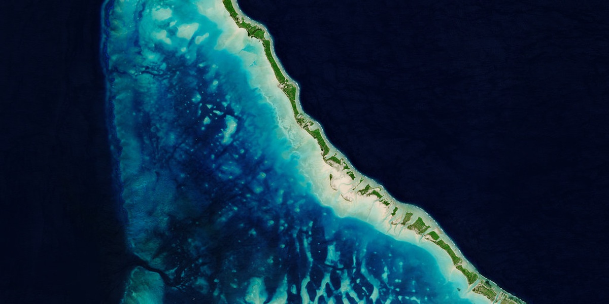
3. Kiritimati (Christmas Island) — Large, isolated atoll with limited emergency response
Kiritimati is one of the largest atolls by land area but has dispersed settlements and only modest medical infrastructure, with a population in the low thousands (approximately 6,000–8,000 residents). Distances between villages and to the main clinic are long, and there are only intermittent air and sea links to Tarawa.
Those logistics matter: medical evacuations require plane or boat travel and can be delayed by bad weather, which in practice means urgent cases sometimes wait many hours or longer for advanced care. Supply shipments — food, fuel, vaccines — arrive on schedules subject to delay, and maintaining cold chains for medicines is a persistent challenge. Periodic droughts have triggered water rationing that affects households and agriculture, showing how isolation turns resource shortfalls into acute risks.
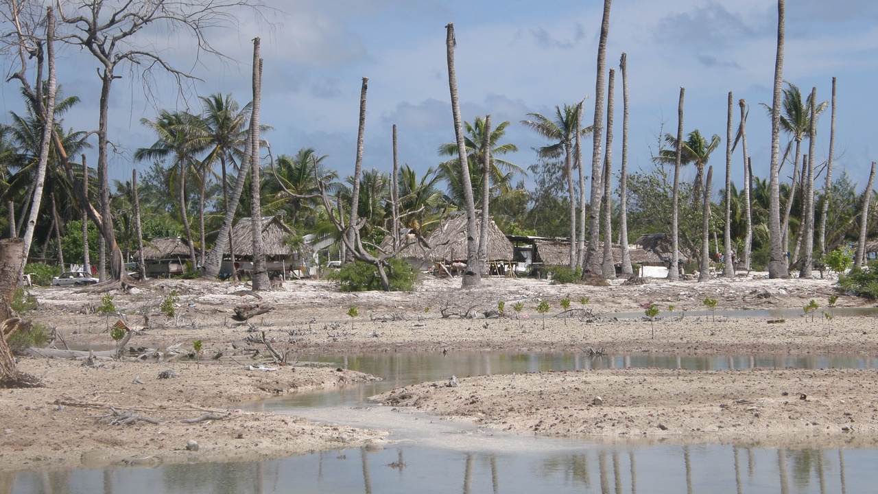
4. Abaiang — Recurrent saltwater intrusion and food insecurity
Abaiang has experienced repeated coastal erosion and saltwater contamination that undermine household agriculture and housing, leaving many people with fewer local food options. Root crops such as taro and pulaka are sensitive to saline water; when freshwater lenses become brackish, yields fall and families shift toward store‑bought food.
Residents report household crop losses in repeated seasons, and small‑scale relocations or community adaptation measures have been discussed and implemented in places. That loss of subsistence production increases reliance on imports and cash income, fuels out‑migration to South Tarawa, and imposes social and mental‑health stresses as traditional livelihoods become less viable.
Infrastructure failures and socioeconomic stress points
Beyond coastal flooding, gaps in clinics, potable water, sanitation, power and transport create hazards that appear even without extreme weather. When pumps stop, toilets back up, or the only local clinic lacks beds or oxygen, small incidents can escalate into life‑threatening events. Socioeconomic pressures such as overcrowding, limited employment and dependence on imported food and fuel make recovery slower.
5. North Tarawa — Infrastructure stress and secondary hazards from overflow
North Tarawa has seen spillover growth from South Tarawa that strains limited services: intermittent water supply, crowded ferry links, and a small clinic with only a handful of beds and minimal emergency equipment. Many households experience scheduled water rationing that affects dozens to hundreds of families at a time.
When water or power interrupts, secondary hazards emerge: waste buildup, increased risk of waterborne disease after rains or king tides, and fuel shortages that impede pumps or clinic generators. Transportation bottlenecks — a delayed ferry or grounded small craft — complicate evacuations and resupply, meaning that otherwise short disruptions can become protracted crises.
Summary
Five locations in Kiribati illustrate how physical exposure, isolation and infrastructure weakness interact to produce elevated risk: South Tarawa and Betio on Tarawa, the remote large atoll Kiritimati, Abaiang with chronic saltwater intrusion, and North Tarawa where spillover strain creates secondary hazards. Together they show patterns that matter for donors, policymakers and communities designing adaptation measures.
- Population concentration: roughly 63,000 people (about half the nation) live on South Tarawa, amplifying flood and sanitation dangers.
- Isolation multiplies risk: Kiritimati’s ~6,000–8,000 residents face long medevac times and periodic supply delays.
- Chronic environmental damage: Abaiang’s saltwater intrusion has reduced taro and pulaka yields, increasing food insecurity and migration.
- Infrastructure limits matter: crowded housing, limited clinic beds and scheduled water rationing on Tarawa turn routine events into emergencies.
- Action needed: targeted adaptation funding, community seawalls and rainwater harvesting (and reporting by UN and UNESCO on small‑island adaptation) are practical priorities.