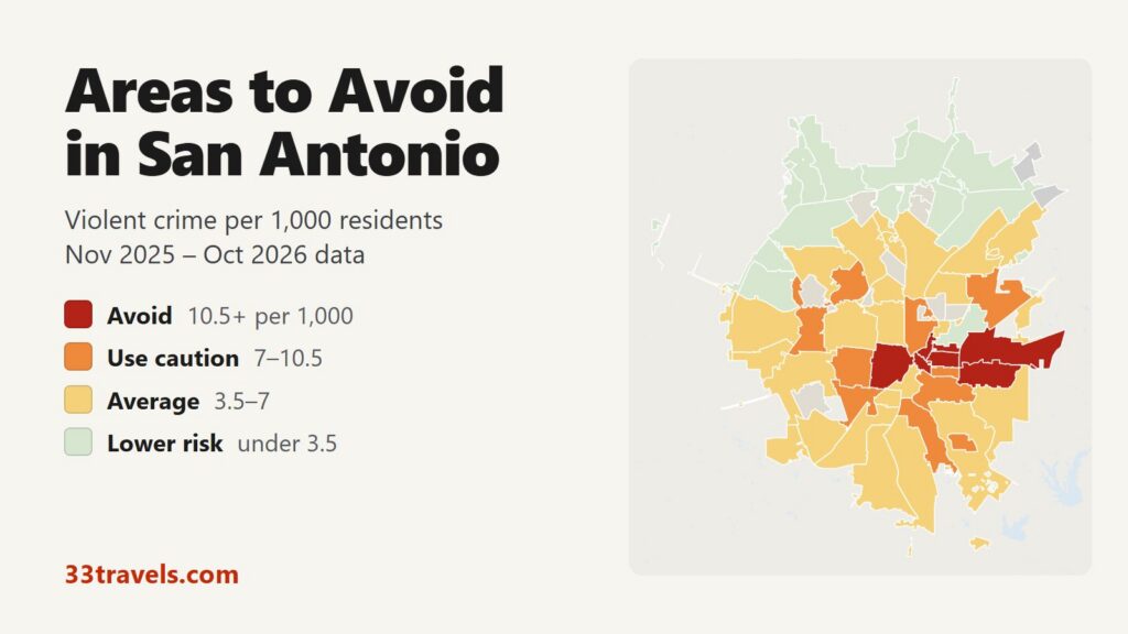
The areas to avoid in San Antonio are the West Side ZIP code that holds Prospect Hill and Market Square, four ZIP codes east of downtown from Dignowity Hill and Government Hill out to the Frost Bank Center and Eastwood, and the two downtown ZIP codes around the River Walk and the Pearl. Between November 2025 and October 2026, 7 ZIP codes recorded 10.5 or more violent crimes per 1,000 residents, roughly double the city rate of 5.3. They house 7% of San Antonio’s residents and account for 17% of its violent crime, 20% of its robberies and 15 of its 80 homicide reports.
Neighborhoods to avoid in San Antonio: Downtown and the River Walk (78205) and the Pearl and Brackenridge Park (78215) in the center. The West Side and Prospect Hill (78207) west of I-35. Dignowity Hill and the Arena District (78202) and Government Hill (78208) on the near East Side. The East Side around Eastgate (78219) and Eastwood and Dellcrest (78220) further east toward I-410.
San Antonio’s rate of 5.3 violent crimes per 1,000 residents is above Austin’s and below Houston’s. Each area on the map is a ZIP code, named after neighborhoods inside it. Downtown and the Pearl rank high because few people live there while many more visit, and most of what happens there is theft. Violent crime was nearly flat over the year, down 1%, while homicide reports fell 18% and vehicle thefts 16%.
San Antonio safety map
Each shape on the San Antonio safety map is a ZIP code inside the city limit. Red ZIP codes are the areas to avoid, orange ones call for caution, yellow ones are near the city average and green ones have the least violent crime. Grey shapes are the separate cities inside San Antonio, such as Alamo Heights, Olmos Park, Terrell Hills, Balcones Heights, Castle Hills and Leon Valley, which have their own police and are not in SAPD’s data. The buttons zoom to Downtown & Inner City, the North Side, the West & Southwest and the East & South. The Theft & robbery layer shows where cars are broken into and stolen. Tap or hover over a ZIP code to see its counts.
Violent crimes per 1,000 residents
Thefts & robberies per area
Tap or hover a ZIP code to see its numbers.
Table of Contents
- Areas to avoid in San Antonio
- Areas to be careful in
- Is downtown San Antonio safe?
- Is the River Walk safe at night?
- Is the East Side of San Antonio safe?
- Is the West Side of San Antonio safe?
- Is Southtown safe?
- San Antonio crime rate
- Car break-ins and car theft in San Antonio
- Where to stay in San Antonio
- New Braunfels, Schertz and the suburbs
- San Antonio safety tips for visitors
- How this map was made
- FAQ
Areas to avoid in San Antonio
The table lists the 7 ZIP codes at or above 10.5 violent crimes per 1,000 residents. Five are in the inner city around downtown. The other two are on the East Side, between downtown and I-410.
| ZIP code | SAPD service area | Violent crimes per 1,000 | vs. city avg | Homicides | Aggravated assaults | Thefts + robberies |
|---|---|---|---|---|---|---|
| Downtown / River Walk (78205)Downtown | Downtown | 67.6 | 12.7x | 3 | 82 | 969 |
| Pearl / Brackenridge (78215)Downtown | Downtown | 17.3 | 3.3x | 0 | 38 | 515 |
| East Side / Eastgate (78219)East | East | 12.0 | 2.3x | 0 | 58 | 355 |
| West Side / Prospect Hill (78207)Central | Central | 11.3 | 2.1x | 4 | 354 | 1,395 |
| Eastwood / Dellcrest (78220)East | East | 11.2 | 2.1x | 4 | 116 | 780 |
| Dignowity Hill / Arena District (78202)East | East | 11.0 | 2.1x | 3 | 87 | 412 |
| Government Hill (78208)East | East | 10.8 | 2.0x | 1 | 27 | 191 |
West Side and Prospect Hill (78207)
With 51,705 residents, 78207 is more than twice the size of any other avoid ZIP, and it recorded 586 violent crimes, more than any other ZIP code in the city. It also leads San Antonio in aggravated assaults (354) and robberies (130). The ZIP covers the historic West Side: Prospect Hill, the Avenida Guadalupe corridor and Our Lady of the Lake University, crossed by I-10 and US 90. Its rate is 11.3 per 1,000.
Two things in 78207 draw outsiders. Historic Market Square, with Mi Tierra and the mercado stalls, sits on its eastern edge, about 250 meters from the downtown ZIP. SAPD headquarters on South Santa Rosa Street also carries a 78207 address. Market Square is patrolled by the San Antonio Park Police.
Near East Side: Dignowity Hill, the Arena District and Government Hill
Dignowity Hill and the Arena District (78202) lie just east of downtown across I-37, around the Dignowity Hill and Harvard Place-Eastlawn neighborhoods. The ZIP recorded 126 violent crimes for 11,422 residents, a rate of 11.0.
Government Hill (78208), to the north, runs from the Pan Am Expressway east to the edge of Fort Sam Houston. It is small, with 3,874 residents, so its rate of 10.8 rests on 42 violent crimes. Near East Side (78203), with the Historic Gardens and Nevada Street neighborhoods south of 78202, falls just under the avoid line at 10.4.
East Side: Eastgate, Eastwood and Dellcrest
East Side and Eastgate (78219) has the highest rate of any ZIP code outside the inner city, 12.0 per 1,000. It holds the Frost Bank Center and the Freeman Coliseum on East Houston Street, home of the Spurs and the San Antonio Stock Show & Rodeo, and the SAPD East substation. With 8,108 residents, it recorded 97 violent crimes and 339 thefts.
Eastwood and Dellcrest (78220) lie in the Eastern Triangle, between I-10 and I-410 along WW White Road and Rigsby Avenue. With 17,569 residents it recorded 197 violent crimes and 4 homicide reports.
Downtown and the Pearl
Downtown and the River Walk (78205) has by far the highest rate in the city, 67.6 per 1,000, and the Pearl and Brackenridge Park (78215) comes second. Only 2,339 people live in 78205, which holds the Alamo, the River Walk, La Villita, Hemisfair, the Tower of the Americas, the Alamodome and most of the big hotels. Every report from a visitor, worker or hotel guest counts against that small resident base.
Areas to be careful in
10 ZIP codes fall between 7 and 10.5 violent crimes per 1,000 residents. With the avoid areas they hold 22% of San Antonio’s residents and 39% of its violent crime. Most are on the East, South and West Sides. Three matter to visitors. Monte Vista and Tobin Hill (78212) holds the San Antonio Zoo and the bars of the St. Mary’s Strip. Highlands and Denver Heights (78210) holds Mission Concepcion. The Medical Center (78229) holds University Hospital, Methodist Hospital and the other hospitals of the South Texas Medical Center, and reports made at those hospitals are counted in the ZIP.
| ZIP code | SAPD service area | Violent crimes per 1,000 | vs. city avg | Homicides | Aggravated assaults | Thefts + robberies |
|---|---|---|---|---|---|---|
| Near East Side (78203)East | East | 10.4 | 2.0x | 0 | 43 | 143 |
| Medical Center / Oak Hills (78229)Prue | Prue | 8.3 | 1.6x | 2 | 160 | 1,195 |
| Monte Vista / Tobin Hill (78212)Downtown | Downtown | 8.2 | 1.5x | 1 | 110 | 982 |
| Highlands / Denver Heights (78210)East | East | 7.8 | 1.5x | 3 | 170 | 766 |
| Stinson / City Base (78235)South | South | 7.8 | 1.5x | 0 | 9 | 268 |
| Mission San Jose / Villa Coronado (78214)South | South | 7.6 | 1.4x | 0 | 111 | 764 |
| Thunderbird Hills / Ingram Park (78238)West | West | 7.6 | 1.4x | 1 | 84 | 1,097 |
| Las Palmas / Westwood Square (78237)West | West | 7.5 | 1.4x | 2 | 189 | 1,164 |
| East Terrell Hills / Camelot I (78218)East | East | 7.2 | 1.4x | 2 | 158 | 941 |
| Port San Antonio / Kelly (78226)South | South | 7.1 | 1.3x | 0 | 30 | 263 |
Is downtown San Antonio safe?
Yes, for a visitor who watches their belongings. The downtown ZIP recorded 934 thefts and 147 stolen vehicles in 12 months, against 158 violent crimes. Those counts are measured against only 2,339 residents, while hotel guests, office workers and day visitors outnumber them many times over. Alamo Plaza, the River Walk loop, La Villita and Hemisfair are patrolled and busy into the evening.
Downtown has its own safety staff. Centro San Antonio runs about 130 downtown ambassadors, and the city added AI cameras on West Commerce Street before the 2025 Final Four and Fiesta. City officials reported that downtown offenses fell 17% in January and February 2025.
Is the River Walk safe at night?
The main River Walk loop, past Casa Rio and the hotel restaurants, stays crowded with diners until closing time. The River Walk is patrolled by the San Antonio Park Police on foot and by boat, and SAPD bike officers cover the stretches cars cannot reach. Theft and fights are the most common problems during big events such as Fiesta, according to SAPD.
The River Walk also runs north to the Pearl on the Museum Reach and south to the missions on the Mission Reach. After dark, stay on the main loop and take a rideshare to the Pearl or Southtown.
Is the East Side of San Antonio safe?
Parts of it are. Four of the seven avoid ZIPs are east of downtown, and the East & South part of town has a rate of 6.5 per 1,000, second only to the inner city. Visitors mostly cross it on the way to a Spurs game or the rodeo at the Frost Bank Center. Drive or take a rideshare to the arena, park in the official lots and leave with the crowd. Pecan Valley and Jupe Manor (78222), which I-410 crosses, and Sunrise (78244) rate average.
Is the West Side of San Antonio safe?
The inner West Side, ZIP 78207, is an avoid area, as described above. Further out the rates drop. Las Palmas and Westwood Square (78237) and Thunderbird Hills around Ingram Park Mall (78238) rate caution. Lackland Terrace (78227), Woodlawn Lake (78201) and the St. Mary’s University area (78228) rate average, although all three record many violent crimes because they are large. Further northwest, Great Northwest (78250) and Stillwater Ranch (78254) rate lower risk.
Is Southtown safe?
Southtown and King William (78204), south of downtown, with the King William historic district, Collins Garden Park and the Lone Star Brewery, rates average at 6.5 per 1,000. Theft is the main problem: 419 thefts against 74 violent crimes.
San Antonio crime rate
SAPD recorded 7,628 violent crimes between November 2025 and October 2026, or 5.3 per 1,000 residents. That is 1% fewer than in the 12 months before. Robberies fell 7%, aggravated assaults rose 2% and homicide reports fell 18%. KSAT’s count of police records puts homicides at 105 in 2025, down from 127 in 2024.
Violent crime is concentrated in the inner city. The Downtown & Inner City ZIPs average 9.3 violent crimes per 1,000 residents, the East & South 6.5, the West & Southwest 5.1 and the North Side 3.5. On the North Side, only the two ZIP codes around the airport, 78216 and 78217, are above the city average.
Car break-ins and car theft in San Antonio
Thefts from vehicles outnumber violent crimes in San Antonio. SAPD recorded 12,999 thefts from vehicles in 12 months, 31% of all thefts, plus 3,475 thefts of car parts and 8,564 stolen vehicles. The pattern is the opposite of violent crime: the most break-ins were in Airport / North Star Mall (78216), around North Star Mall and the airport, followed by UTSA / Tanglewood (78249) near UTSA. Highland Hills / McCreless (78223) on the South Side had the most stolen vehicles. Vehicle thefts fell 16% and break-ins 7% in a year.
Where to stay in San Antonio
Most visitors stay downtown on the River Walk, where most reports are theft. For a quieter base, the North Side has the lowest rates in the city. La Cantera (78256) holds Six Flags Fiesta Texas and The Shops at La Cantera, off I-10 and Loop 1604. The Dominion (78257) and Stone Oak (78258) are residential areas further north. Mahncke Park (78209) puts you near Brackenridge Park, the Witte Museum and Broadway, between downtown and Alamo Heights. Westover Hills (78251) is the base for SeaWorld.
| ZIP code | SAPD service area | Violent crimes per 1,000 | vs. city avg | Homicides | Aggravated assaults | Thefts + robberies |
|---|---|---|---|---|---|---|
| La Cantera / Fiesta Texas (78256)Prue | Prue | 2.8 | 0.5x | 0 | 19 | 600 |
| The Dominion / Camp Bullis (78257)Prue | Prue | 3.1 | 0.6x | 0 | 22 | 968 |
| Stone Oak / Sonterra (78258)North | North | 2.2 | 0.4x | 3 | 63 | 770 |
| UTSA / Tanglewood (78249)Prue | Prue | 3.1 | 0.6x | 2 | 95 | 1,686 |
| Oak Hollow / Lorence Creek (78232)North | North | 2.5 | 0.5x | 0 | 48 | 1,199 |
| Whispering Oaks / Colonial Hills (78230)Prue | Prue | 3.5 | 0.7x | 2 | 101 | 1,333 |
| Westover Hills / SeaWorld (78251)West | West | 3.5 | 0.7x | 2 | 119 | 1,478 |
| Mahncke Park / Oak Park-Northwood (78209)North | North | 3.6 | 0.7x | 1 | 57 | 1,255 |
| Southtown / King William (78204)Downtown | Downtown | 6.5 | 1.2x | 1 | 42 | 433 |
New Braunfels, Schertz and the suburbs
The suburbs along I-35 toward Austin and I-10 toward Seguin report lower violent crime rates than San Antonio. The 5 suburban departments in the table together reported 2.71 violent crimes per 1,000 residents in 2025, against 5.33 for San Antonio in the same FBI data. Cibolo, New Braunfels and Schertz report the lowest rates. Converse, just northeast of the city limit, comes closest to San Antonio’s rate.
| City | Population | Violent crimes | Per 1,000 | Year |
|---|---|---|---|---|
| San Antonio | 1,549,306 | 8,257 | 5.3 | 2025 |
| Converse | 32,352 | 151 | 4.7 | 2025 |
| Seguin | 41,546 | 170 | 4.1 | 2025 |
| Schertz | 45,017 | 109 | 2.4 | 2025 |
| New Braunfels | 123,668 | 275 | 2.2 | 2025 |
| Cibolo | 39,183 | 59 | 1.5 | 2025 |
Murder, rape, robbery and aggravated assault reported to the FBI by each agency, per 1,000 residents of the population the agency reports. Source: FBI Crime Data Explorer. Agencies that report no complete year are left out.
San Antonio safety tips for visitors
- Leave nothing in sight in a parked car, especially at North Star Mall, La Cantera, hotel lots and downtown surface lots. Use a staffed garage downtown.
- Stay on the main River Walk loop after dark and walk the Museum Reach and Mission Reach in daylight.
- Visit Market Square and the Mission Trail in the daytime, and drive or bike between the missions.
- Go to the Frost Bank Center by car or rideshare, and leave with the crowd after the game.
- VIA Metropolitan Transit runs the city buses. It runs a late-night pilot, VIA Link After Midnight, listed on viainfo.net.
- Call 911 in an emergency and SAPD’s non-emergency line, 210-207-7273, to report a crime that is not an emergency.
How this map was made
Crime counts come from the San Antonio Police Department’s public offense records for November 2025 through October 2026, the data behind the city’s Public Safety Dashboard. Violent crime means murder and nonnegligent manslaughter, rape, robbery and aggravated assault. Each offense in a report is counted once, so an assault with three victims counts as one crime; the FBI counts victims, which is why SAPD’s aggravated assault total in this file runs below the FBI’s. The dates are report dates. The suburban table uses each department’s reports to the FBI’s Crime Data Explorer.
SAPD publishes the ZIP code of each offense but no address, so the areas are ZIP codes, using the 2020 Census ZIP code tabulation areas cut to the city limit. Population is the 2020 Census count of the blocks inside each piece. ZIP codes with fewer than 1,000 city residents are merged into a neighbor or left grey, and ZIP 78023 (Helotes), 78109 (Converse) and 78073 (Von Ormy) have city residents but no offenses in the file. 1.25% of offenses carry no usable ZIP. The tiers are Avoid (10.5 or more violent crimes per 1,000 residents), Use caution (7 to 10.5), Average and Lower risk.
Crimes handled by other agencies are missing. Under SAPD policy the Park Police take reports in city parks and on the River Walk and Airport Police at San Antonio International, along with campus police at UTSA, Trinity, Our Lady of the Lake and Texas A&M-San Antonio, and military police at Fort Sam Houston, Lackland and Randolph, which is why the base ZIPs read so low. We built the same map for the areas to avoid in Chicago, the areas to avoid in New York City, the areas to avoid in San Francisco, the areas to avoid in Los Angeles, the areas to avoid in Miami, the areas to avoid in Atlanta, the areas to avoid in Baltimore, the areas to avoid in Detroit, the areas to avoid in Austin, the areas to avoid in Philadelphia, the areas to avoid in St. Louis, the areas to avoid in Boston, the areas to avoid in Denver, the areas to avoid in Houston, the areas to avoid in San Diego, the areas to avoid in Milwaukee, the areas to avoid in Buffalo, the areas to avoid in Jacksonville, the areas to avoid in Phoenix and the areas to avoid in Honolulu.
FAQ
What is the most dangerous part of San Antonio?
By violent crime per resident, the inner West Side (ZIP 78207, around Prospect Hill and Market Square) and the East Side (78219 and 78220, around the Frost Bank Center and the Eastern Triangle) are the most dangerous residential areas. 78207 recorded 586 violent crimes in 12 months, more than any other ZIP code. Downtown has a higher rate, but that rate reflects visitors counted against a small resident population.
Is San Antonio safe for tourists?
Yes. The places tourists go, the Alamo, the River Walk, the Pearl, the missions, SeaWorld and Six Flags, see mostly theft rather than violence. San Antonio's violent crime rate is 5.3 per 1,000 residents, lower than Houston's. Car break-ins are the crime a visitor is most likely to face.
Is it safe to walk the River Walk at night?
The main loop downtown stays busy with diners until the restaurants close and is patrolled by the Park Police and SAPD bike officers. After dark, take a rideshare rather than walking the Museum Reach or Mission Reach to the Pearl or the missions.
What ZIP codes in San Antonio have the most crime?
78207 (West Side) has the most violent crimes. By rate, the avoid ZIP codes are 78205, 78215, 78219, 78207, 78220, 78202 and 78208. 78216, around the airport and North Star Mall, has the most thefts.
What is the safest area of San Antonio?
The far North Side. Stone Oak (78258), Encino Park (78259), Inwood (78248) and the Heights at Stone Oak (78260) have some of the lowest violent crime rates in the city. La Cantera (78256), with Six Flags Fiesta Texas, and the Dominion (78257) also rate lower risk.
Is Market Square in San Antonio safe?
Market Square is a daytime attraction patrolled by the San Antonio Park Police. It sits inside ZIP 78207, which rates avoid, but SAPD's data cannot separate the market from the residential West Side around it. Visit in daylight or during events.
Why do Fort Sam Houston and Randolph show so little crime?
Military police handle incidents on the bases, and their reports are not in SAPD's data. Fort Sam Houston's ZIP shows 2 violent crimes for that reason.