The Marshall Islands’ atolls and islets are scattered records of human stories — from Micronesian voyaging and local governance to 20th‑century military events. Many sites are community landmarks, museums, ruins and wrecks that sit within living island landscapes and require local knowledge to visit.
There are 18 Historical Places in Marshall Islands, ranging from Alele Museum (Marshall Islands Cultural and Historical Museum) to Wotje Atoll Japanese fortifications & wrecks. For each entry you’ll find below the fields Location (Atoll/Island),Period (era/years),Significance (max 15 words; include access note), so you can quickly see where it is, when it matters, and whether public access or permission is required.
How do I plan visits and respect local rules at these sites?
Check the access note in each entry first — some places are on inhabited atolls with community protocols, others are remote or hazardous wreck sites. Arrange local guides or permissions when suggested, pack basic supplies, and follow signage and local advice to minimize impact.
Which places highlight indigenous heritage versus wartime history?
Look at the Period column: museums and cultural sites emphasize indigenous history and traditions, while atolls like Wotje list wartime fortifications and wrecks. Use the Significance field to decide what matches your interest before you travel.
Historical Places in Marshall Islands
| Name | Location (Atoll/Island) | Period (era/years) | Significance (max 15 words; include access note) |
|---|---|---|---|
| Bikini Atoll Nuclear Test Site | Bikini Atoll | 1946–1958 | 1946–58 nuclear test site; UNESCO World Heritage; infrequently accessible |
| Bikini Atoll shipwrecks (lagoon) | Bikini Atoll | 1946 (Operation Crossroads)–1950s | Sunken target ships from tests; remote diving site; infrequently accessible |
| Enewetak Nuclear Test Area | Enewetak Atoll | 1948–1958 | Major nuclear test series site; contaminated zones; access restricted/infrequently accessible |
| Runit Dome | Runit Island,Enewetak Atoll | 1979–1980 | Concrete radioactive debris containment; hazardous legacy; restricted, unsafe proximity |
| Enjebi Island wartime remains | Enjebi Island,Enewetak Atoll | 1944–1950s | WWII invasion site and test-era ruins; infrequently accessible |
| Rongelap Atoll (affected villages) | Rongelap Atoll | 1954 (Castle Bravo)–present | Affected by 1954 fallout; contamination history; infrequently accessible |
| Utrik Atoll fallout-impacted sites | Utrik Atoll | 1954 (Castle Bravo) | Impacted by 1954 fallout; community historical sites; infrequently accessible |
| Rongerik Atoll temporary relocation sites | Rongerik Atoll | 1946–1957 | Temporary relocation site for Bikini residents; contamination concerns; infrequently accessible |
| Kili Island (Bikini resettlement) | Kili Island,Kwajalein Atoll | 1948–present | Resettlement island for Bikini islanders; inhabited, public access |
| Kwajalein WWII battlefields & fortifications | Kwajalein Atoll | 1944 (Battle of Kwajalein) | Major WWII battlefields and fortifications; US-controlled, restricted access |
| Roi-Namur WWII and Cold War sites | Roi-Namur,Kwajalein Atoll | 1944 (WWII)–Cold War | Japanese WWII sites and later missile/radar installations; restricted access |
| Alele Museum (Marshall Islands Cultural and Historical Museum) | Majuro,Majuro Atoll | Collections span centuries | National museum with Marshallese artifacts and exhibits; public, visitable |
| Majuro WWII airfield & base remains | Majuro Atoll | 1944–1945 | US-built WWII airfield and base remains; publicly visible, visitable |
| Laura WWII bunkers & gun emplacements | Laura area,Majuro Atoll | 1941–1945 | Japanese/US bunkers and gun emplacements from WWII; publicly accessible |
| Jaluit administrative ruins (German and Japanese eras) | Jaluit Atoll (Jabor) | 1885–1945 | Former German colonial and Japanese administrative center ruins; infrequently accessible |
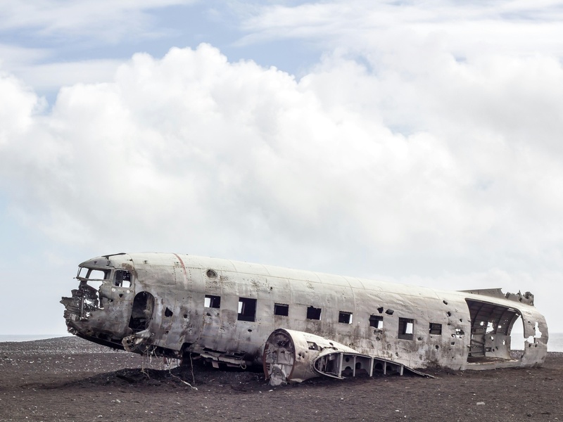
| Wotje Atoll Japanese fortifications & wrecks | Wotje Atoll | 1941–1945 | Extensive Japanese fortifications and wartime wrecks; infrequently accessible |
| Mili Atoll airfields and wrecks | Mili Atoll | 1941–1945 | Japanese airfield, bunkers and shipwrecks; infrequently accessible |
| Maloelap Atoll wartime base remains | Maloelap Atoll | 1941–1945 | Japanese wartime base ruins and wrecks; infrequently accessible |
Images and Descriptions

Bikini Atoll Nuclear Test Site
Located in Bikini Atoll. Used by the United States for major nuclear tests from 1946 to 1958. Marks global nuclear history and large-scale island displacement. Contains test craters and abandoned infrastructure. Remains contaminated in places and is UNESCO-listed for its cultural and natural values. Access is limited; visits require local permission and guided arrangements. Include as a key nuclear-test site in the Marshall Islands.
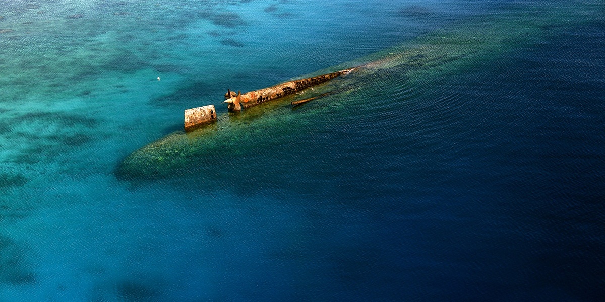
Bikini Atoll shipwrecks (lagoon)
Scattered across Bikini Lagoon. Warships and naval vessels sank during nuclear tests and World War II. Provide dramatic underwater wrecks and clear evidence of testing impact. Popular for technical diving and research. Lagoon access requires permits and dive operators familiar with radiation history. Fit the post as prominent historic and dive attractions tied to nuclear testing.

Enewetak Nuclear Test Area
Located in Enewetak Atoll. Host to U.S. nuclear tests from 1948 to 1958. Holds blast sites, instrument islands, and altered ecosystems. Involves long-term cleanup and resettlement history. Some areas remain monitored for contamination. Visits often require permission from local authorities and coordination with environmental agencies. Include as another principal nuclear-test location in the islands.

Runit Dome
Sits on Runit Island in Enewetak Atoll. Built in the 1970s to store radioactive soil and debris from nuclear tests. Appears as a concrete cap over contaminated waste. Raises concerns about leakage and sea-rise vulnerability. Access is restricted and poorly regulated. Serve as a stark, modern relic of nuclear remediation efforts in the Marshall Islands.
Enjebi Island wartime remains
Part of Enewetak Atoll. Contains military structures and test-era installations from the 1940s–1950s. Shows island use for war and nuclear operations. Features ruins and foundations scattered across the island. Access is limited and may need permission from local leaders. Include as an example of nuclear-era infrastructure and wartime legacy.
Rongelap Atoll (affected villages)
Located northeast of Bikini Atoll. Heavily affected by fallout from the 1954 Castle Bravo test. Houses contaminated villages, evacuation stories, and long-term health impacts. Features relocation history and partial resettlement efforts. Some islands allow visits but residents control access and require permission. Include for its human and environmental consequences of testing.
Utrik Atoll fallout-impacted sites
Located near Rongelap. Experienced fallout contamination after nuclear testing in the 1950s. Contains affected village sites and health legacy records. Shows broader regional impact beyond test locations. Access depends on local permissions and community readiness to host visitors. Include to show multiple atolls affected by nuclear fallout.
Rongerik Atoll temporary relocation sites
Used as a temporary home for displaced Bikini Islanders in the late 1940s. Shows ruins of short-lived settlements and resource strain. Represents relocation policies tied to testing. Remains largely uninhabited and remote. Visits require permission and boat transport. Include for its role in the human displacement story.
Kili Island (Bikini resettlement)
Small, populated island used to resettle Bikini people after testing. Became a long-term home despite limited resources and no airstrip. Holds community sites, cultural continuity, and resettlement history. Access requires coordination and likely boat transport. Include as the human and cultural outcome of nuclear relocation.
Kwajalein WWII battlefields & fortifications
Located in Kwajalein Atoll. Scene of intense WWII fighting in 1944. Contains bunkers, battlefields, and sunken vessels. Later became a U.S. military range and support base. Access is highly restricted in many areas due to U.S. Army operations; limited civilian visits need clearance. Include as a major WWII site with ongoing military presence.
Roi-Namur WWII and Cold War sites
Part of Kwajalein Atoll. Hosts wartime ruins from 1944 and Cold War radar and tracking installations. Shows layered military history from Japanese defenses to U.S. missile tests. Some areas remain in active use and have restricted access. Include for combined WWII and Cold War significance.
Alele Museum (Marshall Islands Cultural and Historical Museum)
Located in Majuro. Serves as the national repository for Marshallese artifacts and history. Exhibits include cultural items, colonial records, and historical documents. Open to the public during set hours and easy to visit in Majuro town. Include as the primary place to learn Marshall Islands history and access authoritative local sources.
Majuro WWII airfield & base remains
Found on Majuro Atoll. Includes remnants of wartime airstrips and support facilities built during World War II. Shows Allied expansion across the Pacific. Parts remain visible near modern infrastructure. Access is generally open in Majuro, with some private or restricted areas. Include as a local WWII heritage site easily seen by visitors.
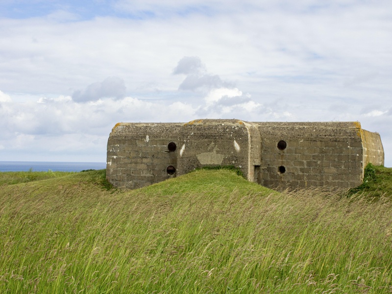
Laura WWII bunkers & gun emplacements
Located on the Laura peninsula of Majuro. Hosts Japanese-era bunkers and coastal guns from World War II. Presents well-preserved concrete fortifications and landscape scars. Accessible by road and often visited on local history tours. Include for clear, walkable examples of wartime defenses.
Jaluit administrative ruins (German and Japanese eras)
Located on Jaluit Atoll. Served as the German colonial capital and later Japanese administrative center. Contains ruins of government buildings, docks, and warehouses. Shows layers of colonial rule in the Marshalls. Access requires boat travel and local permission. Include for colonial-era administrative history and archaeological interest.
Wotje Atoll Japanese fortifications & wrecks
Located in Wotje Atoll. Contains Japanese fortifications, bunkers, and shipwrecks from World War II. Offers visible shore defenses and underwater wreck sites. Access is by boat and can be remote; local clearance may be needed. Include as a strong example of island wartime infrastructure and wreck diving.
Mili Atoll airfields and wrecks
Found on Mili Atoll. Hosts former Japanese airfields, crashed planes, and sunken ships from WWII battles. Displays extensive battlefield remains across islands and lagoon. Access is remote and requires charter transport plus local permission. Include for its concentration of wartime aviation and naval wreckage.
Maloelap Atoll wartime base remains
Located on Maloelap Atoll. Contains a former Japanese military base with bunkers, airstrip traces, and wrecks. Shows island-scale military construction and wartime logistics. Access is by boat and often remote; obtain local permission before visiting. Include as part of the chain of Marshall Islands WWII bases.