Afghanistan’s landscape holds layers of human history — Hellenistic cities, Buddhist monasteries, and medieval forts — spread across plains, river valleys and high plateaus. These sites reflect long-distance trade, shifting empires and local craftsmanship that shaped the region over millennia.
There are 19 Ruins in Afghanistan, ranging from Ai Khanoum to Tepe Sardar (Bamiyan Buddhist complex). For each, you’ll find below Location,Era,Condition & access.
Are these sites safe and accessible to visit?
Access and safety vary widely: some well-known sites are reachable with local guides and proper permits, while others lie in remote or restricted areas and may be closed due to security or conservation work. Check current travel advisories, contact local authorities or tour operators, and plan for rugged travel conditions and seasonal limits.
How accurate are the Era and Condition entries in the list?
Era and condition summaries are based on published archaeological research, surveys and conservation reports, but dates can be approximate and site conditions change. Use the list as a starting point and verify specifics with recent field reports, museum publications or local heritage organizations before planning a visit.
Ruins in Afghanistan
| Name | Location | Era | Condition & access |
|---|---|---|---|
| Bamiyan Buddhas (cliff niches) | Bamiyan Province; Bamiyan; 34.802,67.825 | 6th–7th c. CE | Niches and cliff remains; limited access |
| Shahr-e Gholghola (City of Screams) | Bamiyan Province; near Bamiyan; 34.807,67.833 | 10th–13th c. CE | Ruined citadel and walls; open to visitors |
| Shahr-e Zuhak (Red City) | Bamiyan Province; near Bamiyan; 34.829,67.856 | 5th–14th c. CE | Ruined hill fortress; public access |
| Tepe Sardar (Bamiyan Buddhist complex) | Bamiyan Province; Bamiyan area; 34.805,67.827 | 3rd–8th c. CE | Excavated ruins and mosaics; limited access |
| Takht-e Rustam (Samangan) | Samangan Province; Aibak; 36.266,68.016 | 5th–7th c. CE | Rock-cut monastery and stupas; accessible |
| Ai Khanoum | Takhar Province; near Ay-Khanum; 36.687,70.225 | 3rd–2nd c. BCE (Hellenistic) | Ruined Hellenistic city; controlled access |
| Surkh Kotal | Baghlan Province; near Pol-e Khomri; 35.990,68.701 | 1st–3rd c. CE (Kushan) | Ruined temple complex and inscriptions; limited access |
| Hadda (archaeological site) | Nangarhar Province; Jalalabad area; 34.389,70.455 | 1st–6th c. CE | Ruined monasteries and stupas; many artifacts removed |
| Mes Aynak | Logar Province; near Kabul; 33.525,68.945 | 2nd c. BCE–7th c. CE | Extensive ruins under threat; restricted access |
| Balkh (ancient Bactra) | Balkh Province; near Mazar‑e‑Sharif; 36.756,66.897 | Iron Age–medieval | Archaeological mounds and ruins; accessible |
| Herat Citadel (Qala Ikhtyaruddin) | Herat Province; Herat; 34.346,62.201 | 7th c. CE foundations; rebuilt later | Partly restored citadel; open to public |
| Minaret of Jam | Ghor Province; Shahrak area; 34.645,63.145 | 12th c. CE (Ghurid) | Standing, endangered minaret; restricted access |
| Ghazni Citadel & Minarets | Ghazni Province; Ghazni city; 33.553,68.417 | 11th–13th c. CE (Ghaznavid) | Partly ruined; restricted/controlled access |
| Qala-e-Bost (Bost Fort) | Helmand Province; near Lashkargah; 31.546,64.367 | 8th–13th c. CE phases | Ruined fortress and arch; accessible with caution |
| Bala Hissar (Kabul) | Kabul Province; Kabul; 34.520,69.148 | Antiquity–19th c. | Ruined fortress; military/restricted access |
| Firozkoh (Shahr‑i Ghor) | Ghor Province; near Chaghcharan; 33.345,65.242 | 12th–13th c. CE (Ghorid) | Ruined capital remains; remote access |
| Takht-e Rustam (Bamiyan area) | Bamiyan Province; near Ahin; 34.810,67.786 | 5th–7th c. CE | Rock-cut stupa complex; accessible |
| Mundigak (Bronze Age city) | Kandahar Province; near Kandahar; 31.000,66.958 | 3rd–2nd millennia BCE | Ruined Bronze Age settlement; restricted access |
| Shortugai (Indus outpost) | Takhar Province; near Amu Darya; 37.070,69.030 | 3rd millennium BCE (Harappan) | Earthwork ruins and fields; remote access |
Images and Descriptions

Bamiyan Buddhas (cliff niches)
Famous colossal Buddha niches once held giant statues carved into the Bamiyan cliffs. The statues were destroyed in 2001 but niches, monasteries and cave remains date to early medieval Buddhism. A poignant, iconic ruin; visitors can reach the valley, but facilities are basic.
Shahr-e Gholghola (City of Screams)
Medieval fortified town destroyed by Mongols; earthworks, collapsed walls and remnants of houses survive on a hill near Bamiyan. It illustrates post-Buddhist urban life and violent destruction. Accessible on foot from Bamiyan with interpretive signs but limited services.
Shahr-e Zuhak (Red City)
A dramatic ruin of a fortified settlement and watch towers clinging to a cliff ridge above the valley. Origins reach early medieval times; successive occupation left visible towers and walls. Popular with tourists; paths are uneven and exposure is high.
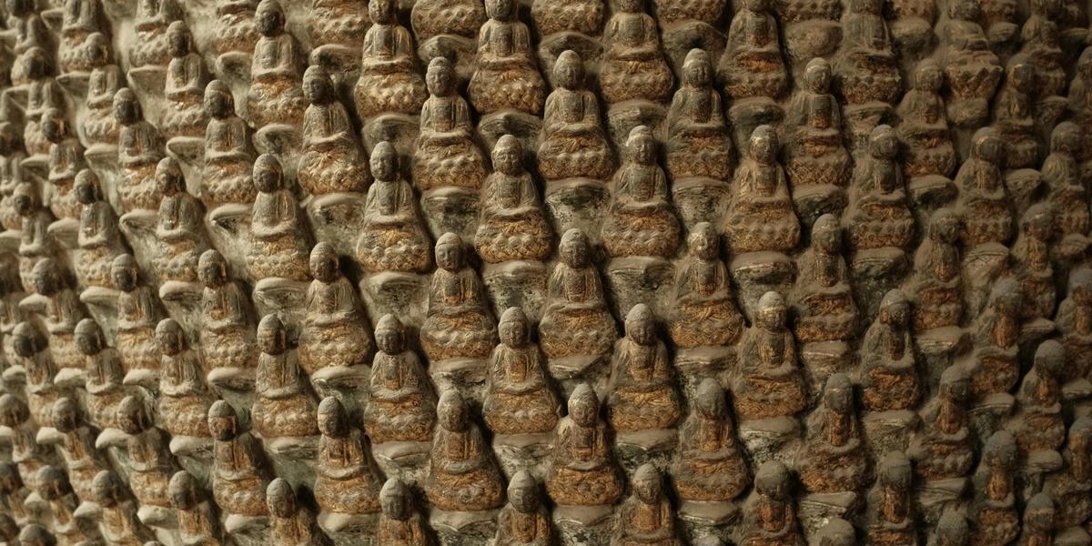
Tepe Sardar (Bamiyan Buddhist complex)
Large monastery complex with stupas and wall paintings showing Greco-Buddhist art. Excavations revealed painted stucco and structural phases from Kushan to early Islamic periods. Fragile remains; visits are possible but many finds are in museums.
Takht-e Rustam (Samangan)
Rock-cut Buddhist monastery with carved stupas, chapels and monk cells on a hill near Aibak. Well-preserved reliefs and caves show a regional monastic center. Easy to visit from Samangan though signage and facilities are modest.
Ai Khanoum
Major Hellenistic city at the Oxus’ edge, with Greek-style architecture, a forum, temples and inscriptions. Founded after Alexander’s campaigns, it blends Greek and Central Asian urbanism. Excavated but remote; visits require planning and permits.
Surkh Kotal
Kushan-era hilltop sanctuary with monumental traces, a large stairway and royal inscriptions. Important for understanding early Kushan kings and religion. Visible remains are fragile and the site is reachable by regional road with limited visitor services.
Hadda (archaeological site)
Extensive Greco-Buddhist monasteries and sculptures near Jalalabad. Excavations produced important stucco figures and reliefs, many now in museums. Traces of stupas and foundations remain; parts of the site have been looted and access varies.
Mes Aynak
Large Buddhist town and monastery complex with stupas, murals and a major ancient copper-smelting industry. Mes Aynak reveals long-term urban and religious life but is severely threatened by modern mining. Archaeologists work under tight security; public visits are limited.
Balkh (ancient Bactra)
One of Afghanistan’s oldest cities, Bactra contains layered mounds, temple platforms and remnant walls spanning millennia. It was a major Achaemenid, Hellenistic and Buddhist center later Islamicized. Ruins are visible around modern Balkh with local guides available.
Herat Citadel (Qala Ikhtyaruddin)
A long-occupied fortress in Herat’s center, with foundations from early medieval times and later Timurid rebuilding. Restoration has preserved walls and towers, but original ruined fabric remains. Popular, accessible museum spaces exist within the complex.
Minaret of Jam
A towering, intricately-brick Ghurid minaret set in a remote valley, decorated with Kufic inscriptions and geometric tilework. UNESCO-listed and highly vulnerable to erosion and looting. Trek access is challenging and visits often need local arrangements and permits.
Ghazni Citadel & Minarets
Ghazni’s medieval citadel and several tall minarets testify to its role as a Ghaznavid capital. Repeated damage has left collapsed towers and defensive walls; some restoration and excavation work exist. Access can be limited for security and conservation reasons.
Qala-e-Bost (Bost Fort)
A vast mud-brick and stone fortress overlooking the Helmand River, famed for a dramatic arched gateway. Layers reflect Islamic medieval occupation. The fort is partly collapsed but visible from Lashkargah; travel advisories and local conditions affect visits.
Bala Hissar (Kabul)
Historic hilltop citadel controlling Kabul for centuries, with foundations from ancient to colonial eras. Bombardment and neglect left ruins of palaces and walls. It remains strategically used at times; public access is often restricted and variable.
Firozkoh (Shahr‑i Ghor)
Ruins of the Ghorid dynasty’s summer capital include foundations, walls and mosque fragments. Once a regional power center, the scattered ruins now sit in a remote upland landscape. Visiting requires planning and awareness of local conditions.
Takht-e Rustam (Bamiyan area)
A separate Bamiyan-area rock-cut complex with carved stupas, chapels and monastic cells. The site illustrates local Buddhist architecture and ritual spaces; weathering and past destruction make many features fragile. Often visited with Bamiyan valley tours.
Mundigak (Bronze Age city)
An important early urban center with large mud-brick mounds, fortifications and craft levels dating to the 3rd–2nd millennium BCE. Mundigak offers a window on prehistoric urbanism in South Asia’s fringes. Excavations have revealed monumental platforms; site access is limited and remote.
Shortugai (Indus outpost)
A Harappan-era trading outpost on the Oxus, Shortugai shows long-distance trade with the Indus civilization. Ruined walls, channels and settlement mounds survive in a floodplain setting. Remote location and seasonal conditions make visits challenging; archaeology is specialized.