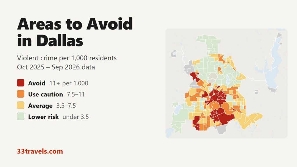
The areas to avoid in Dallas are South Dallas around Fair Park and the Cedars, south Oak Cliff, the Red Bird area in the far southwest, downtown and Deep Ellum, north Oak Cliff around Bishop Arts, the La Bajada side of West Dallas and the blocks south and east of Bachman Lake. Between October 2025 and September 2026, 25 police beat areas recorded 11 or more violent crimes per 1,000 residents, twice the city rate of 5.6. They are home to 11% of Dallas residents but account for 31% of its violent crime, 31% of its aggravated assaults and 50 of the 132 homicides police recorded in those 12 months.
Neighborhoods to avoid in Dallas: the Cedars and South Boulevard, Fair Park and Edgewood, Bonton, Wheatley Place, Mill City, Rose Garden and the east end of Pemberton Hill in South Dallas. Highland Hills, Kessler Heights, Arden Terrace, Adelaide, Oak Cliff Gardens, Overton Road, Heart of Oak Cliff and the Tenth Street area north of the zoo in south Oak Cliff. Red Bird and the Wheatland Road corridor in the far southwest. Bishop Arts and the surrounding blocks of north Oak Cliff, and La Bajada in West Dallas. Downtown, Deep Ellum and Bryan Place, and the Swiss Avenue area in East Dallas. Bachman Lake (south and east) near Love Field.
Dallas has a violent crime rate of 5.6 per 1,000 residents, close to San Antonio’s and well below Houston’s. Downtown and Deep Ellum rank high partly because few people live there and many more come to work, eat and go out, and most crime recorded there is theft. Violent crime fell 7% from the year before, homicides 9% and robberies 14%.
Dallas safety map
Dallas has no official neighborhood boundaries, so each shape on the Dallas safety map is a police beat, or a few small beats merged, named after the neighborhood where most of its residents live. Red areas are the areas to avoid, orange ones call for caution, yellow ones sit near the city average and green ones have the least violent crime. Grey shapes are University Park, Highland Park and Cockrell Hill, separate cities with their own police inside the Dallas city limit. The buttons zoom to Downtown & Central, North Dallas, East & Southeast and West & Oak Cliff. Switch to the Theft & robbery layer to see where cars are broken into and stolen. Tap or hover over an area for its counts.
Violent crimes per 1,000 residents
Thefts & robberies per area
Tap or hover a neighborhood to see its numbers.
Table of Contents
- Areas to avoid in Dallas
- Areas to be careful in
- Is downtown Dallas safe?
- Is Deep Ellum safe?
- Is Uptown Dallas safe?
- Is Oak Cliff safe? Bishop Arts and the south
- Is Fair Park safe during the State Fair?
- Dallas crime rate
- Car break-ins and car theft in Dallas
- Safest neighborhoods to stay in Dallas
- Plano, Frisco and the suburbs
- Dallas safety tips for visitors
- How this map was made
- FAQ
Areas to avoid in Dallas
The table lists the 25 areas at or above 11 violent crimes per 1,000 residents. Nineteen lie south of downtown and the Trinity River, in South Dallas, Oak Cliff and the Red Bird area. The other six are downtown, Deep Ellum, Swiss Avenue, La Bajada in West Dallas and two parts of the Bachman Lake neighborhood in Northwest Dallas.
| Area (police beat) | Council district | Violent crimes per 1,000 | vs. city avg | Homicides | Aggravated assaults | Thefts + robberies |
|---|---|---|---|---|---|---|
| Cedars-South BoulevardDistrict 7 | District 7 | 29.1 | 5.2x | 1 | 96 | 378 |
| Pemberton Hill (east)District 8 | District 8 | 23.3 | 4.2x | 4 | 54 | 44 |
| Fair Park-EdgewoodDistrict 7 | District 7 | 22.7 | 4.1x | 1 | 65 | 171 |
| BontonDistrict 7 | District 7 | 22.2 | 4.0x | 4 | 89 | 116 |
| Bishop Arts-North Oak CliffDistrict 1 | District 1 | 22.1 | 4.0x | 1 | 43 | 337 |
| DowntownDistrict 14 | District 14 | 21.0 | 3.8x | 1 | 91 | 964 |
| Highland HillsDistrict 8 | District 8 | 20.3 | 3.6x | 3 | 121 | 127 |
| Red BirdDistrict 3 | District 3 | 19.0 | 3.4x | 3 | 77 | 221 |
| Wheatley PlaceDistrict 7 | District 7 | 18.9 | 3.4x | 3 | 80 | 94 |
| Mill CityDistrict 7 | District 7 | 18.4 | 3.3x | 2 | 90 | 110 |
| Bachman Lake (south)District 6 | District 6 | 17.8 | 3.2x | 3 | 64 | 436 |
| Kessler HeightsDistrict 4 | District 4 | 17.1 | 3.1x | 2 | 53 | 67 |
| Arden TerraceDistrict 8 | District 8 | 14.7 | 2.6x | 1 | 45 | 95 |
| Deep Ellum-Bryan PlaceDistrict 2 | District 2 | 14.5 | 2.6x | 4 | 98 | 964 |
| Rose GardenDistrict 7 | District 7 | 14.1 | 2.5x | 1 | 36 | 52 |
| AdelaideDistrict 4 | District 4 | 13.8 | 2.5x | 0 | 46 | 40 |
| Oak Cliff GardensDistrict 4 | District 4 | 13.3 | 2.4x | 1 | 74 | 124 |
| Overton RoadDistrict 4 | District 4 | 12.5 | 2.2x | 0 | 34 | 38 |
| West Dallas (La Bajada)District 6 | District 6 | 12.5 | 2.2x | 4 | 64 | 265 |
| Heart of Oak CliffDistrict 4 | District 4 | 11.8 | 2.1x | 4 | 67 | 95 |
| Swiss AvenueDistrict 14 | District 14 | 11.2 | 2.0x | 0 | 21 | 157 |
| Tenth Street-Zoo NorthDistrict 4 | District 4 | 11.2 | 2.0x | 2 | 38 | 98 |
| Bachman Lake (east)District 6 | District 6 | 11.0 | 2.0x | 0 | 35 | 42 |
| Hampton-WheatlandDistrict 8 | District 8 | 11.0 | 2.0x | 3 | 40 | 137 |
| Wheatland-DanieldaleDistrict 8 | District 8 | 11.0 | 2.0x | 2 | 25 | 105 |
South Dallas, the Cedars and Fair Park
Cedars-South Boulevard has the highest rate in Dallas, 29.1 per 1,000, with 141 violent crimes for 4,850 residents. It joins the Cedars, south of I-30 around DART’s Cedars Station, with the South Boulevard-Park Row historic district further east. Dallas police headquarters on South Lamar Street is inside it.
East of the Cedars, Fair Park-Edgewood holds Fair Park and the Cotton Bowl and rates 22.7. South of it lie Wheatley Place (18.9), around the Wheatley Place Historic District, and Bonton (22.2), along the Bexar Street corridor. Bonton recorded 4 homicides, one of the highest counts in the city. Mill City (18.4) and Rose Garden (14.1) lie east of Fair Park. Further southeast, beside the Great Trinity Forest, the blocks east of Jim Miller Road at the end of Pemberton Hill rate 23.3 on only 3,181 residents.
South Oak Cliff and Highland Hills
South Oak Cliff holds eight of the avoid areas, more than any other part of the city. Highland Hills, centered on Bonnie View Road and Simpson Stuart Road, recorded 121 aggravated assaults, the most of any area in Dallas, and 142 violent crimes in all. Kessler Heights, a different place from Kessler Park in north Oak Cliff, sits between Ledbetter Drive and I-45 and rates 17.1. Arden Terrace (14.7) borders it to the south.
Closer to the center, Adelaide (13.8), Oak Cliff Gardens (13.3) and the Overton Road area around Kiest Boulevard and Bonnie View Road (12.5) are all above the avoid line. Heart of Oak Cliff, around Linfield Road in the southeast corner of Oak Cliff, recorded 4 homicides. The Tenth Street Historic District, just north of the Dallas Zoo, rates 11.2.
Red Bird and the Wheatland Road corridor
In the far southwest, Red Bird holds the RedBird mall site and Dallas Executive Airport, once Red Bird Airport. It recorded 134 violent crimes, a rate of 19.0. Two areas south of it along Wheatland Road and US 67, Hampton-Wheatland (11.0) and Wheatland-Danieldale (11.0), sit right at the avoid line.
North Oak Cliff and West Dallas
Bishop Arts-North Oak Cliff contains the Bishop Arts District, the restaurant and shopping area at Bishop Avenue and Davis Street, and the blocks around it toward Kidd Springs. It recorded 67 violent crimes for 3,033 residents, a rate of 22.1, and 173 stolen vehicles. The section on Oak Cliff below covers what that means for a visit. Across the Trinity, West Dallas (La Bajada) takes in La Bajada and the Fort Worth Avenue corridor and rates 12.5, with 4 homicides.
Downtown, Deep Ellum and East Dallas
Downtown recorded 149 violent crimes, more than any other area in Dallas, but only 7,109 people live there, and its rate of 21.0 counts only them, not the office workers, hotel guests and visitors who fill it every day. Deep Ellum-Bryan Place, east of the elevated I-345, joins the Deep Ellum entertainment district with the Bryan Place homes to its north and Baylor University Medical Center. It recorded 148 violent crimes, a rate of 14.5.
The Swiss Avenue area in East Dallas, with the Swiss Avenue Historic District and the blocks around it, crosses the line at 11.2 on 40 violent crimes.
Bachman Lake
The neighborhood south and east of Bachman Lake, between Love Field and Northwest Highway, has the highest rates in North Dallas. Bachman Lake (south) recorded 111 violent crimes, a rate of 17.8, and 402 thefts. Bachman Lake (east) rates 11.0. Love Field itself sits in Elm Thicket-Northpark, which rates lower risk at 2.0.
Areas to be careful in
39 areas fall between 7.5 and 11 violent crimes per 1,000 residents. Together with the avoid areas they hold 27% of Dallas residents and 57% of its violent crime. Most surround the avoid areas in southern Dallas and Pleasant Grove. A few matter to visitors: Old East Dallas next to Deep Ellum, Henderson Avenue near Knox Street, Love Field West-Parkland, which holds Parkland Hospital and counts reports made there, and Vickery Meadows near NorthPark Center. Greenville-LBJ and Lake Highlands along I-635 are the highest-rated areas in Northeast Dallas.
| Area (police beat) | Council district | Violent crimes per 1,000 | vs. city avg | Homicides | Aggravated assaults | Thefts + robberies |
|---|---|---|---|---|---|---|
| OwenwoodDistrict 7 | District 7 | 10.9 | 2.0x | 0 | 57 | 93 |
| Pleasant Grove (Glenview)District 5 | District 5 | 10.8 | 1.9x | 1 | 45 | 68 |
| Westmoreland-WheatlandDistrict 3 | District 3 | 10.7 | 1.9x | 0 | 26 | 93 |
| GlenviewDistrict 3 | District 3 | 10.5 | 1.9x | 0 | 34 | 56 |
| Bickers ParkDistrict 6 | District 6 | 10.2 | 1.8x | 1 | 35 | 68 |
| KenningstonDistrict 5 | District 5 | 10.2 | 1.8x | 0 | 32 | 51 |
| Old East DallasDistrict 2 | District 2 | 10.2 | 1.8x | 0 | 18 | 136 |
| Fort Worth AvenueDistrict 6 | District 6 | 9.9 | 1.8x | 1 | 31 | 151 |
| Pleasant Grove (far south)District 5 | District 5 | 9.9 | 1.8x | 0 | 46 | 62 |
| Polk TerraceDistrict 8 | District 8 | 9.8 | 1.8x | 0 | 44 | 63 |
| Wynnewood NorthDistrict 1 | District 1 | 9.8 | 1.8x | 1 | 26 | 144 |
| Bachman Lake (west)District 6 | District 6 | 9.7 | 1.7x | 0 | 40 | 78 |
| Greenville-LBJDistrict 10 | District 10 | 9.7 | 1.7x | 1 | 73 | 266 |
| Pemberton HillDistrict 8 | District 8 | 9.6 | 1.7x | 1 | 29 | 57 |
| Wheatland Meadows (south)District 8 | District 8 | 9.6 | 1.7x | 0 | 42 | 39 |
| Wheatland HillsDistrict 8 | District 8 | 9.4 | 1.7x | 1 | 23 | 82 |
| Zoo Creek ParkDistrict 4 | District 4 | 9.3 | 1.7x | 2 | 41 | 111 |
| Lake Highlands (LBJ)District 10 | District 10 | 9.1 | 1.6x | 0 | 37 | 78 |
| Cedar CrestDistrict 4 | District 4 | 8.9 | 1.6x | 0 | 28 | 100 |
| Pleasant Grove (northwest)District 5 | District 5 | 8.7 | 1.6x | 0 | 28 | 39 |
| East Kessler ParkDistrict 1 | District 1 | 8.6 | 1.5x | 1 | 30 | 123 |
| Joppa-Trinity ForestDistrict 7 | District 7 | 8.6 | 1.5x | 2 | 23 | 32 |
| Lakeland HillsDistrict 7 | District 7 | 8.5 | 1.5x | 0 | 65 | 351 |
| Mount AuburnDistrict 2 | District 2 | 8.5 | 1.5x | 2 | 35 | 56 |
| Beverly HillsDistrict 1 | District 1 | 8.4 | 1.5x | 2 | 35 | 327 |
| Buckner Terrace (east)District 7 | District 7 | 8.2 | 1.5x | 2 | 34 | 209 |
| Love Field West-ParklandDistrict 2 | District 2 | 8.1 | 1.5x | 1 | 41 | 387 |
| Oak Park EstatesDistrict 4 | District 4 | 8.1 | 1.5x | 0 | 35 | 62 |
| Southern HillsDistrict 4 | District 4 | 8.1 | 1.5x | 2 | 21 | 48 |
| UrbandaleDistrict 5 | District 5 | 8.1 | 1.5x | 0 | 20 | 53 |
| Henderson AvenueDistrict 2 | District 2 | 8.0 | 1.4x | 1 | 25 | 186 |
| Highland Hills (south)District 8 | District 8 | 8.0 | 1.4x | 0 | 21 | 170 |
| Vickery Meadows (central)District 13 | District 13 | 8.0 | 1.4x | 0 | 49 | 87 |
| Wheatland Meadows (north)District 8 | District 8 | 8.0 | 1.4x | 0 | 29 | 35 |
| Park CentralDistrict 11 | District 11 | 7.9 | 1.4x | 0 | 30 | 83 |
| Lake Highlands (Wickersham)District 10 | District 10 | 7.8 | 1.4x | 0 | 24 | 47 |
| North Oak LawnDistrict 14 | District 14 | 7.7 | 1.4x | 1 | 55 | 432 |
| Vickery Meadows (north)District 13 | District 13 | 7.6 | 1.4x | 0 | 35 | 320 |
| LedbetterDistrict 6 | District 6 | 7.5 | 1.3x | 0 | 20 | 46 |
Is downtown Dallas safe?
Yes, during the day and in the busy blocks at night. Dealey Plaza, Reunion Tower, the Arts District and the AT&T Discovery District draw crowds, and most crime recorded downtown is theft. Downtown recorded 917 thefts and 220 stolen vehicles in 12 months, against 149 violent crimes. DPD reported in July 2025 that violent crime in the Central Business District was down 23% from a year earlier.
The east side of downtown, Downtown (east), rates average at 6.6. It holds The Stewpot, a homeless services center on Corsicana Street. After dark, stay around Main Street, Elm Street, the Arts District and the hotels near Reunion, and use a rideshare between them and Deep Ellum or Uptown.
Is Deep Ellum safe?
Deep Ellum is crowded and patrolled on weekend nights, but it has also seen deadly nightlife violence. Three shootings in about 75 minutes after midnight on November 1, 2026, Halloween weekend, killed 4 people and injured at least 15 as the bars emptied. Federal prosecutors and DPD answered with Operation Deep Cover, which adds officers and prosecutions in the district. In March 2026 the city had already approved a safety plan with a late-night entertainment permit, more police and more cameras.
In the 12 months on the map, Deep Ellum-Bryan Place recorded 148 violent crimes, second only to downtown, along with 926 thefts and 233 stolen vehicles, the most of any area in the city. It also leads Dallas in car break-ins. Leave before closing time, park in a staffed lot and keep nothing in the car.
Is Uptown Dallas safe?
Yes. Uptown is one of the safest parts of central Dallas, with a rate of 1.2 per 1,000 and 9 violent crimes in 12 months. State-Thomas (1.9) and Knox-Henderson (0.9) rate lower risk too. Uptown Dallas Inc. and DPD opened a safety headquarters on McKinney Avenue in June 2025. The risk in Uptown is theft, most of it from parked cars: Uptown recorded 263 thefts, many times its violent count. The free M-Line trolley runs along McKinney Avenue between Uptown and the Arts District until midnight on Fridays and Saturdays.
Is Oak Cliff safe? Bishop Arts and the south
Oak Cliff, the large part of Dallas across the Trinity River from downtown, is very different at its north and south ends. North Oak Cliff is mixed. Kidd Springs, next to Bishop Arts, rates lower risk at 1.6, Winnetka Heights rates average and East Kessler Park rates caution. The Bishop Arts-North Oak Cliff area rates avoid, but its count is 67 violent crimes on a small residential base, and its 173 stolen vehicles rank among the most in the city. Its restaurants on Bishop Avenue and Davis Street stay busy in the evening. Park on a lit street, or take the Dallas Streetcar, which ends at Bishop Arts.
South Oak Cliff, with eight avoid areas, is where violent crime in Dallas is most concentrated. The Dallas Zoo is its main visitor attraction.
Is Fair Park safe during the State Fair?
During the State Fair of Texas and the Cotton Bowl games, Fair Park is crowded and heavily policed. The 2025 State Fair added a clear-bag rule, banned guns for everyone except law enforcement and required visitors 17 and under to have an adult chaperone after 5 p.m. DART adds police, security staff and ambassadors on fair days and for the Texas-OU game. Outside events, Fair Park sits inside Fair Park-Edgewood, an avoid area at 22.7 per 1,000. Take DART to Fair Park and leave with the crowd.
Dallas crime rate
Dallas police recorded 7,396 violent crimes between October 2025 and September 2026, or 5.6 per 1,000 residents, 7% fewer than in the 12 months before. Robberies fell 14% and aggravated assaults 5%. For calendar 2025, DPD reported 141 homicides, down from 183 in 2024 and the fewest since 2015. Police Chief Daniel Comeaux credits the city’s violent crime plan, which concentrates patrols on small hot-spot grids and targets repeat offenders.
Violent crime is concentrated in southern Dallas. The South Central Division averages 9.8 violent crimes per 1,000 residents and the Southeast Division 7.8, against 2.2 in the North Central Division, which covers Far North Dallas and Preston Hollow. Among the 14 council districts, District 7, which takes in South Dallas and Fair Park, has the highest rate at 11.8. District 12 in Far North Dallas and District 9 around White Rock Lake have the lowest.
Car break-ins and car theft in Dallas
Car break-ins are the crime a visitor to Dallas is most likely to face. Police recorded 11,713 thefts from vehicles in 12 months, 46% of all thefts, plus 3,302 thefts of car parts such as catalytic converters and 8,813 stolen vehicles. Break-ins rose 9%, while vehicle thefts fell 24%.
The pattern differs from violent crime. Deep Ellum-Bryan Place had the most break-ins, followed by Downtown, the Design District and Vickery Place near lower Greenville Avenue. Even the safest areas for violent crime see theft: Lakewood recorded 261 thefts and Knox-Henderson 331. In September 2026 Lower Greenville residents reported a spike in break-ins, and DPD added patrols.
Safest neighborhoods to stay in Dallas
Uptown is a low-risk base for a short visit: it is close to downtown, the Arts District and the M-Line, with one of the lowest violent crime rates in central Dallas. State-Thomas and Knox-Henderson are next door. Lakewood, next to White Rock Lake, and Lower Greenville and Greenland Hills, near the Greenville Avenue bars, rate lower risk in East Dallas. Kidd Springs puts you in walking distance of Bishop Arts. Preston Royal and Prestonwood are the low-risk choices in North Dallas.
| Area (police beat) | Council district | Violent crimes per 1,000 | vs. city avg | Homicides | Aggravated assaults | Thefts + robberies |
|---|---|---|---|---|---|---|
| UptownDistrict 14 | District 14 | 1.2 | 0.2x | 0 | 4 | 268 |
| State-ThomasDistrict 14 | District 14 | 1.9 | 0.3x | 0 | 8 | 194 |
| Knox-HendersonDistrict 14 | District 14 | 0.9 | 0.2x | 0 | 6 | 333 |
| LakewoodDistrict 9 | District 9 | 0.7 | 0.1x | 0 | 8 | 262 |
| Lower GreenvilleDistrict 14 | District 14 | 0.6 | 0.1x | 0 | 2 | 211 |
| Greenland HillsDistrict 14 | District 14 | 2.1 | 0.4x | 1 | 4 | 232 |
| Kidd SpringsDistrict 1 | District 1 | 1.6 | 0.3x | 0 | 8 | 75 |
| Preston RoyalDistrict 13 | District 13 | 1.9 | 0.3x | 0 | 16 | 420 |
| PrestonwoodDistrict 12 | District 12 | 1.0 | 0.2x | 0 | 15 | 108 |
Plano, Frisco and the suburbs
The suburbs report far less violent crime than Dallas. The suburban departments in the table together reported 2.29 violent crimes per 1,000 residents in 2025, against 5.77 for Dallas in the same FBI data. Flower Mound, Prosper and Southlake report the lowest rates. Plano, Frisco, Richardson and Carrollton all report under 1.5. Mesquite and Arlington come closest to Dallas.
| City police department | Population | Violent crimes | Per 1,000 | Year |
|---|---|---|---|---|
| Dallas | 1,331,217 | 7,683 | 5.8 | 2025 |
| Mesquite | 150,193 | 681 | 4.5 | 2025 |
| Arlington | 406,035 | 1,653 | 4.1 | 2025 |
| Fort Worth | 1,030,410 | 3,864 | 3.8 | 2025 |
| Haltom City | 45,733 | 164 | 3.6 | 2025 |
| Lancaster | 40,640 | 140 | 3.4 | 2025 |
| DeSoto | 56,851 | 162 | 2.9 | 2025 |
| Irving | 258,220 | 692 | 2.7 | 2025 |
| Duncanville | 38,858 | 101 | 2.6 | 2025 |
| Lewisville | 138,488 | 302 | 2.2 | 2025 |
| Denton | 172,882 | 354 | 2.1 | 2025 |
| Anna | 37,165 | 75 | 2.0 | 2025 |
| Grand Prairie | 210,147 | 420 | 2.0 | 2025 |
| Garland | 251,332 | 480 | 1.9 | 2025 |
| Bedford | 48,460 | 87 | 1.8 | 2025 |
| Hurst | 39,299 | 68 | 1.7 | 2025 |
| Grapevine | 51,460 | 85 | 1.7 | 2025 |
| Euless | 59,746 | 95 | 1.6 | 2025 |
| Rowlett | 69,502 | 109 | 1.6 | 2025 |
| Cedar Hill | 49,723 | 77 | 1.6 | 2025 |
| Burleson | 58,540 | 90 | 1.5 | 2025 |
| North Richland Hills | 71,725 | 108 | 1.5 | 2025 |
| Plano | 295,030 | 434 | 1.5 | 2025 |
| Little Elm | 65,337 | 91 | 1.4 | 2025 |
| The Colony | 46,183 | 64 | 1.4 | 2025 |
| Richardson | 117,915 | 163 | 1.4 | 2025 |
| Farmers Branch | 37,609 | 50 | 1.3 | 2025 |
| McKinney | 235,731 | 271 | 1.2 | 2025 |
| Mansfield | 82,937 | 88 | 1.1 | 2025 |
| Royse City | 31,093 | 31 | 1.0 | 2025 |
| Frisco | 244,103 | 240 | 1.0 | 2025 |
| Carrollton | 135,908 | 133 | 1.0 | 2025 |
| Coppell | 41,505 | 40 | 1.0 | 2025 |
| Wylie | 64,291 | 52 | 0.8 | 2025 |
| Allen | 115,905 | 91 | 0.8 | 2025 |
| Keller | 46,881 | 35 | 0.8 | 2025 |
| Sachse | 34,679 | 24 | 0.7 | 2025 |
| Celina | 53,580 | 27 | 0.5 | 2025 |
| Melissa | 30,479 | 15 | 0.5 | 2025 |
| Southlake | 31,561 | 14 | 0.4 | 2025 |
| Prosper | 48,795 | 21 | 0.4 | 2025 |
| Flower Mound | 80,891 | 34 | 0.4 | 2025 |
Murder, rape, robbery and aggravated assault reported to the FBI by each police department in Dallas, Collin, Denton and Tarrant counties, per 1,000 residents of the population the department reports. Calendar year 2025. Source: FBI Crime Data Explorer. Cities with fewer than 30,000 residents and departments that report no complete year are left out.
Dallas safety tips for visitors
- Leave nothing in sight in a parked car, in Deep Ellum, downtown, the Design District and Uptown above all. Use staffed garages where you can.
- In Deep Ellum, leave before the bars close and walk with the crowd on Elm Street.
- Take a rideshare between downtown, Deep Ellum, Uptown and Bishop Arts at night instead of walking under the freeways.
- Go to Fair Park and the Cotton Bowl on DART on event days and leave with the crowd.
- DART runs light rail to both airports: the Orange Line to DFW Terminal A, the Silver Line to Terminal B and bus Route 5 to Love Field. Red Line trains run until after midnight; check the schedule for your line.
- Report problems on DART to DART Police at 214-749-5900 or through the DART Say Something app, and call 214-928-6300 in an emergency.
- Call 911 in an emergency and DPD’s non-emergency line, 214-744-4444, to report a crime that is not an emergency.
How this map was made
Violent crime comes from the City of Dallas Crime Analytics dashboard, built by the city with the Dallas Police Department, for October 2025 through September 2026. It counts murder, rape (including sodomy and sexual assault with an object), robbery and aggravated assault under the FBI’s NIBRS rules, family violence included, and it matches the FBI’s 2025 count for Dallas within 3%. The city’s open-data police file leaves out family violence and sexual offenses, so it is used here only for theft, vehicle theft and burglary, where it matches the FBI’s totals. The dates are the dates the crimes occurred, and the last months may still rise as reports are filed.
The dashboard gives counts per police beat, not addresses. Each area is one DPD beat, or a few neighboring beats merged to reach 3,000 residents, and population is the 2020 Census count of the blocks inside it. A few downtown beats returned no figure for part of the year, which leaves the downtown count slightly low. Areas with fewer than 3,000 residents, such as the West End, Cypress Waters and the freeway corridors, are shown without a rate. The tiers are Avoid (11 or more violent crimes per 1,000 residents), Use caution (7.5 to 11), Average and Lower risk. The suburban table uses each department’s reports to the FBI’s Crime Data Explorer.
Crimes handled by other agencies are missing: DART Police on trains, buses and stations, UT Southwestern Police, the Dallas County Hospital District Police at Parkland, Dallas College Police and the separate departments of University Park, Highland Park and Cockrell Hill. We built the same map for the areas to avoid in Chicago, the areas to avoid in New York City, the areas to avoid in San Francisco, the areas to avoid in Los Angeles, the areas to avoid in Miami, the areas to avoid in Atlanta, the areas to avoid in Baltimore, the areas to avoid in Detroit, the areas to avoid in Austin, the areas to avoid in Philadelphia, the areas to avoid in St. Louis, the areas to avoid in Boston, the areas to avoid in Denver, the areas to avoid in Houston, the areas to avoid in San Diego, the areas to avoid in Milwaukee, the areas to avoid in Buffalo, the areas to avoid in Jacksonville, the areas to avoid in Phoenix, the areas to avoid in Honolulu, the areas to avoid in San Antonio and the areas to avoid in Oklahoma City.
FAQ
What is the most dangerous part of Dallas?
By violent crime per resident, South Dallas around Fair Park and the Cedars and south Oak Cliff around Highland Hills are the most dangerous parts of Dallas. Cedars-South Boulevard has the highest rate, 29.1 violent crimes per 1,000 residents, and Highland Hills recorded the most aggravated assaults, 121 in 12 months.
Is Dallas safe for tourists?
Yes. The places most visitors go, downtown, Uptown, the Arts District, Dealey Plaza, Klyde Warren Park and Bishop Arts, see mostly theft. Dallas has a violent crime rate of 5.6 per 1,000 residents, and police recorded 11,713 break-ins of parked cars in 12 months. A car break-in is the crime a visitor is most likely to face.
What neighborhoods should you avoid in Dallas?
The 25 areas to avoid are the Cedars, Fair Park, Bonton, Wheatley Place, Mill City, Rose Garden and the east end of Pemberton Hill in South Dallas; Highland Hills, Kessler Heights, Arden Terrace, Adelaide, Oak Cliff Gardens, Overton Road, Heart of Oak Cliff and Tenth Street in south Oak Cliff; Red Bird and the Wheatland Road corridor; Bishop Arts and La Bajada; downtown, Deep Ellum and Swiss Avenue; and the south and east sides of Bachman Lake.
Is Deep Ellum safe at night?
Deep Ellum is crowded and patrolled on weekend nights, but three shootings after midnight on November 1, 2026 killed 4 people there, and Deep Ellum-Bryan Place recorded 148 violent crimes in 12 months, second only to downtown. Go early, leave before the bars close and use a rideshare.
What is the safest area to stay in Dallas?
Uptown is a low-risk base, with 9 violent crimes in 12 months and the free M-Line trolley to the Arts District. State-Thomas, Knox-Henderson, Lakewood and Lower Greenville also rate lower risk, as do Preston Royal and Prestonwood in North Dallas.
Is crime in Dallas going down?
Yes. Violent crime fell 7% between the last two 12-month periods, robberies 14% and homicides 9%. For calendar 2025 DPD counted 141 homicides, down from 183 in 2024 and the fewest since 2015. Vehicle thefts fell 24%, but car break-ins rose 9%.
Is Dallas more dangerous than Fort Worth?
By FBI figures for 2025, yes. Dallas reported 5.77 violent crimes per 1,000 residents, against 3.75 for Fort Worth and 4.07 for Arlington. Plano, Frisco and Richardson reported under 1.5.
Is DART safe to ride?
DART has its own police force, and crimes on its trains, buses and stations are not in the city data on this map. In November 2026 DART started Operation Access, 90 days of extra police, fare checks and security staff, with mandatory fare validation at Pearl/Arts District and West End stations. Report problems to DART Police at 214-749-5900, or 214-928-6300 in an emergency.