Timor-Leste’s towns, forts and colonial quarters are compact archives of layered history — from local kingdoms and Portuguese rule to 20th-century conflict and cultural renewal. Walking those streets or visiting hilltop outposts gives a direct sense of how place, memory and community intersect across the island.
There are 25 Historical Places in Timor-Leste, ranging from Balibo Fort to Venilale colonial area. For each site you’ll find below entries organized by Location, Era, Significance so you can compare where something is, roughly when it dates from, and why it matters — you’ll find below detailed listings to help plan visits or research.
Which sites can I realistically see in a weekend in Timor-Leste?
Aim for a single district to minimize travel time: choose a base town (for example Dili or Baucau), pick 3–4 nearby entries from the list, check local transport and opening times, and allow extra time for unpaved roads; shorter visits work best when you combine walking tours with one longer trip to a key site.
How reliable are the Era and Significance notes, and should I double-check them?
The entries summarize commonly reported dates and reasons for importance but can reflect differing local accounts; treat them as starting points — consult local guides, museum staff or official heritage sources if you need definitive dating or detailed historical records.
Historical Places in Timor-Leste
| Name | Location | Era | Significance |
|---|---|---|---|
| Santa Cruz Cemetery | Dili District; Santa Cruz, Dili; coords -8.56,125.60 | Late 20th century (1991) | Site of 1991 massacre; national independence memorial |
| Government Palace | Dili City; Praça de República area, Dili; coords -8.56,125.59 | Portuguese colonial / 19th–20th century | Colonial administrative seat; landmark of governance history |
| National Museum of Timor-Leste | Dili City; near waterfront, Dili; coords -8.55,125.57 | Contemporary museum; collections span prehistory–present | Houses artifacts documenting Timorese history and culture |
| Museum of Resistance | Dili City; near Tasi Tolu, Dili; coords -8.56,125.60 | Post-independence (documents 1975–1999) | Exhibits on Indonesian occupation and resistance movement |
| Becora Prison | Dili City; Becora area, Dili | Indonesian occupation era (1975–1999) | Former detention site used during occupation and repression |
| Balibo House | Bobonaro District; Balibo town | 1975 (Balibo Five) | Site associated with the “Balibo Five” journalists killings |
| Balibo Fort | Bobonaro District; Balibo town | Portuguese colonial era | Colonial-era fortification overlooking Balibo town |
| Maubara Fort | Liquiçá District; Maubara town | 17th century (Portuguese) | Well-preserved Portuguese fort and colonial cemetery |
| Maubara Dutch Cemetery | Liquiçá District; Maubara town | 19th–20th century | European colonial-era cemetery with historic graves |
| Lifau (first Portuguese settlement) | Oecusse-Ambeno SAR; Lifau | 17th century | First Portuguese foothold in Timor; colonial founding site |
| Pante Macassar historic area | Oecusse-Ambeno SAR; Pante Macassar town | Portuguese colonial era | Colonial town core with forts, churches, and cemeteries |
| Suai Church | Cova Lima District; Suai town | 1999 | Site of 1999 massacre; memorial to conflict victims |
| Liquiçá Church | Liquiçá District; Liquiçá town | 1999 | Massacre site during 1999 turmoil; local memorial |
| Baucau colonial district | Baucau Municipality; Baucau town; coords -8.47,126.50 | Portuguese colonial era | Colonial administration buildings and prominent Catholic church |
| Baucau Airport (Cakung) | Baucau Municipality; near Baucau town; coords -8.48,126.50 | 1940s; WWII and colonial era | Historic airfield used in WWII and later occupation periods |
| Maubisse town (colonial core) | Ainaro District; Maubisse town | Portuguese colonial era | Mountain town with colonial houses and resistance history |
| Mount Ramelau (Tatamailau) | Ainaro District; near Hatolia | Pre-colonial to present | Sacred mountain and pilgrimage site; cultural symbol |
| Mount Matebian | Baucau District; near Laga | Resistance era prominence (late 20th c.) | Symbolic mountain; guerrilla refuge during independence struggle |
| Cristo Rei (Fatucama) | Dili District; Cape Fatucama, near Dili; coords -8.57,125.62 | 1996 (Indonesian era) | Large statue and pilgrimage site; modern national landmark |
| Venilale colonial area | Baucau Municipality; Venilale town | Portuguese colonial era | Colonial architecture, WWII tunnels, and local traditions |
| Lospalos traditional area | Lautem Municipality; Lospalos town | Pre-colonial and colonial periods | Fataluku sacred houses and enduring cultural ceremonies |
| Tutuala rock art and caves | Lautem Municipality; Tutuala Peninsula | Prehistoric (thousands of years) | Cave shelters with prehistoric rock art and archaeological remains |
| Baucau Catholic Church (St. Anthony) | Baucau Municipality; Baucau town | Portuguese colonial era | Major colonial-era church and community landmark |
| Lahane (Governor’s residence) | Dili District; Lahane village | Portuguese colonial era | Governor’s summer residence; colonial administrative and historical site |
| Venilale WWII tunnels | Baucau Municipality; Venilale town | World War II / colonial era | Tunnels and shelters used during WWII and occupation periods |
Images and Descriptions

Santa Cruz Cemetery
Marks the 1991 massacre site in Dili and serves as a national memorial for victims of the independence struggle. Holds rows of graves, memorial plaques, and public gathering space for ceremonies. Stands as a key place for modern Timorese history and collective memory.
Government Palace
Functions as the official seat of Timor-Leste’s government in Dili. Shows colonial and modern architecture and hosts state events. Serves as a symbol of national authority and post-independence governance.

National Museum of Timor-Leste
Houses artifacts on Timorese art, culture, and history from prehistory to independence. Presents exhibits on traditional life, colonial rule, and resistance. Acts as a central resource for researchers and visitors seeking reliable historical context.
Museum of Resistance
Focuses on the struggle against Portuguese and Indonesian rule. Displays documents, photos, and objects from resistance movements. Provides clear context for Timor-Leste’s fight for independence and its costs.

Becora Prison
Serves as a former detention site used during the Indonesian occupation. Contains cell blocks and memorial markers that link to human rights abuses. Remains an important place for understanding political repression in recent history.
Balibo House
Commemorates the 1975 killings of journalists in Balibo. Preserves the house site and memorial plaque linked to early conflict events. Stands as a reminder of dangers faced by reporters and the escalation of violence in 1975.
Balibo Fort
Offers colonial-era military ruins near the border with Indonesia. Shows Portuguese defensive architecture and strategic coastal location. Helps explain colonial control and local resistance in western Timor.
Maubara Fort
Contains well-preserved Portuguese fortifications and a hilltop chapel. Dates to the 17th century and overlooks the coast and mangroves. Illustrates long-term colonial presence and local maritime history.

Maubara Dutch Cemetery
Holds colonial-era graves linked to Dutch influence and regional trade. Features stone markers and European-style memorials. Provides insight into foreign presence and historical contacts in western Timor.

Lifau (first Portuguese settlement)
Marks the 16th–17th century site where Portugal first established presence on Timor. Contains church ruins and historic shoreline views. Explains the start of formal colonial rule and missionary activity in the island.

Pante Macassar historic area
Includes old churches, colonial buildings, and coastal forts in Oecusse enclave. Reflects Portuguese and regional history with unique local culture. Shows how border and enclave status shaped local development.
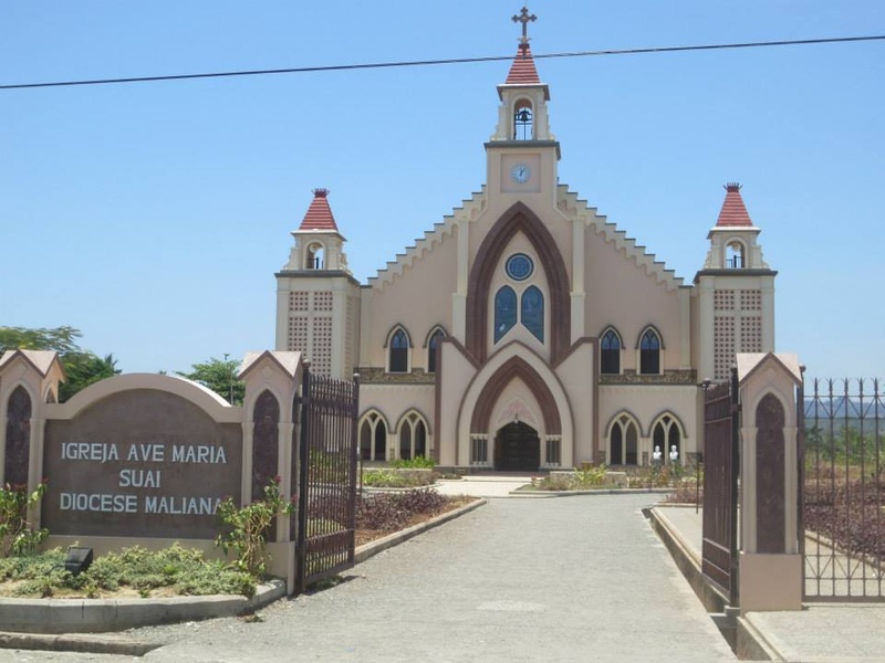
Suai Church
Serves as a major parish church with links to conflict events during independence struggles. Holds religious services and stands as a community focal point. Represents both faith and the local experience of national trauma.

Liquiçá Church
Functions as a historic church tied to violent events during 1999. Contains memorials and rebuilt structures. Provides context for nationalist conflict and efforts at community recovery.
Baucau colonial district
Hosts a cluster of colonial buildings, government houses, and tree-lined streets. Retains Portuguese-era urban layout and architecture. Offers a clear example of colonial town planning outside Dili.
Baucau Airport (Cakung)
Operates as a historic airfield that served colonial, wartime, and post-independence transport. Retains a long runway and old terminal buildings. Helps explain regional connectivity and strategic importance.
Maubisse town (colonial core)
Contains a compact colonial center with old houses, a market, and hilltop views. Shows Portuguese-era town design adapted to highland life. Serves as an example of rural colonial administration and architecture.
Mount Ramelau (Tatamailau)
Offers the highest peak in Timor-Leste and a sacred Christian pilgrimage site. Hosts a large Cristo Rei statue and mountain shrines. Blends natural significance with modern religious and national symbolism.
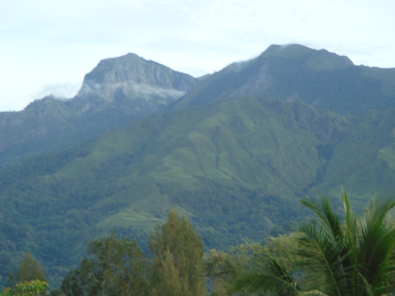
Mount Matebian
Serves as a sacred mountain and historic resistance hideout during independence struggles. Contains shrines and rugged hiking paths. Represents spiritual importance and guerrilla-era history.

Cristo Rei (Fatucama)
Presents a large statue of Christ overlooking Dili from Fatucama hill. Functions as a major religious landmark and panoramic viewpoint. Symbolizes the role of Catholicism in national identity.
Venilale colonial area
Includes colonial-era buildings, a historic church, and nearby WWII tunnels. Shows Portuguese architecture in an inland town setting. Acts as a mix of colonial, wartime, and local heritage sites.
Lospalos traditional area
Houses traditional villages, woven crafts, and ancestral sites in the east. Preserves Timorese cultural practices, timber houses, and local ceremonies. Offers rich insight into indigenous life and continuity.
Tutuala rock art and caves
Contains ancient petroglyphs and cave art in the easternmost region. Shows human presence and ritual practice dating back thousands of years. Provides deep-time context for Timor-Leste’s cultural history.
Baucau Catholic Church (St. Anthony)
Serves as a longstanding parish church in Baucau with colonial roots. Features classic architecture and religious artifacts. Reflects the central role of the Catholic Church in community life.
Lahane (Governor’s residence)
Holds the historic hilltop governor’s house used during colonial times. Offers views over Dili and surrounding valleys and retains colonial design cues. Connects political history to physical landscape.
Venilale WWII tunnels
Comprises wartime tunnels and bunkers carved into the hills around Venilale. Dates to World War II and later local use. Illustrates the island’s strategic role in regional conflicts and local wartime memories.